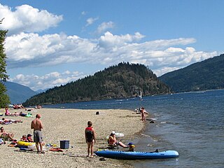
Adams Lake Provincial Park is a provincial park in British Columbia, Canada. It encompasses three distinct parks: Adams Lake Provincial Park, Adams Lake Marine Provincial Park, and Adams Lake Marine Provincial Park.
Big Creek Provincial Park is a provincial park in British Columbia, Canada.
Charlie Lake Provincial Park is a provincial park in British Columbia, Canada, established on the western shore of Charlie Lake. It is roughly 92 hectares in size.
Eakin Creek Floodplain Provincial Park is a provincial park in British Columbia, Canada located on the North Thompson River near the community of Little Fort.
Eakin Creek Canyon Provincial Park is a provincial park in British Columbia, Canada, located on the west side of the North Thompson River near the community of Little Fort. The park is approximately 10 ha. in size.
Junction Sheep Range Provincial Park is a provincial park in British Columbia, Canada, located near the confluence of the Chilcotin and Fraser Rivers on the west bank of the latter river.
Johnstone Creek Provincial Park is a provincial park in British Columbia, Canada, located west of the confluence of Rock Creek and the Kettle River and the town of Rock Creek. The park has a roughly 38 hectare area, and is near to the Crowsnest Highway.
Momich Lakes Provincial Park is a provincial park in British Columbia, Canada, located at the north end of Adams Lake 100 kilometres (62 mi) northeast of Kamloops.
Upper Adams River Provincial Park is a provincial park in British Columbia, Canada.
Pritchard Provincial Park is a provincial park in British Columbia, Canada, located on the north side of the South Thompson River between the communities of Monte Creek, to the west, and Chase, to the east. The park lies approximately 40 kilometres (25 mi) northeast of the city of Kamloops. The park itself is split into two geographically separated sections.
Pukeashun Provincial Park is a provincial park in British Columbia, Canada, located north of the community of Scotch Creek, near the city of Salmon Arm. The park is named for Pukeashun Mountain which is within its boundaries and a major local landmark. It protects part of the Adams Plateau, the southeastern portion of the Shuswap Highland.
Pyramid Creek Falls Provincial Park is a provincial park in British Columbia, Canada, located on the east side of the North Thompson River between the towns of Blue River (S) and Valemount (N).
Schoolhouse Lake Provincial Park, formerly known as Lang Lake Provincial Park, is a provincial park in British Columbia, Canada.

Shuswap Lake Provincial Park is a provincial park in British Columbia, Canada.
Shuswap Lake Marine Provincial Park is a provincial park in British Columbia, Canada, comprising 894 ha. The Park has a variety of amenities including boat launch ramps, picnic areas, and 27 campsites around the perimeter of Shuswap Lake. The lake's name and that of the surrounding Shuswap Country is from the Shuswap people (Secwepemc), the most northern of the Salishan speaking people.

The Bonaparte Indian Band a.k.a. Bonaparte First Nation, is a member band of the Shuswap Nation Tribal Council of the Secwepemc (Shuswap) people.
The Tlʼesqox First Nation is a Tsilhqotʼin community located west of the Fraser Canyon in the Chilcotin region of the Canadian province of British Columbia. It is a member of the Carrier-Chilcotin Tribal Council, which includes both Tsilhqotʼin and Carrier (Dakelh) communities.

The Canim River is a river in the South Cariboo region of the Interior of British Columbia, Canada. It begins at the outlet of Canim Lake and runs 1.8 km (1.1 mi) to Canim Falls, then continues 8 km (5.0 mi) via a canyon cut into a lava plateau to Mahood Lake. A second outlet from Canim Lake, also part of the Canim River, flows over Mahood Falls and joins the Canim Falls branch.
The Kakwa River is a tributary of the Smoky River in western Alberta, Canada.
Oregana Creek Provincial Park is a provincial park in British Columbia, Canada, located 150 kilometres northwest of Salmon Arm, British Columbia, near Adams River. The park, which is 286 ha. in size, was established in 2010.


