Capilano River Regional Park is most commonly associated with the Cleveland Dam. Admission to the dam is free, and one can walk across the dam and observe the river and the spillway. Formed above the dam, Capilano Lake stores the river's waters, stretching north for more than five kilometres. The lake is one of three major watersheds in the GVRD, and it currently supplies forty percent of the region's drinking water. Water treatment facilities are located adjacent to the dam, and a tunneling project scheduled for completion in 2008 will connect the reservoir to a new treatment plant at the Seymour Dam to the east.
There is also the Capilano Fish Hatchery in the park, about 500 metres downhill from the Cleveland Dam. Admission is free. The hatchery receives 238,000 visitors annually and is widely recognized for its contribution of coho and steelhead to the sport fishery in Burrard Inlet. The hatchery offers educational displays explaining the type of work that is done there, as well as basic education about the life cycles of the fish in the area. There is also a cross-section display of an active fish ladder. During spawning seasons, the fish ladder is heavily used by fish in the area that use it to bypass the dam.
The rugged waters of the Capilano River within the park also attracts kayakers and canoers. There are also a number of nature and biking trails in the park, and it is frequently used as a location for film and television production most notably MacGyver, Smallville, Tin Man and Twilight: New Moon.
Transportation
Street access is by way of Capilano Road in the District of North Vancouver. There are parking lots at the Cleveland Dam, near the top of Capilano Road, and at the fish hatchery along Capilano Park Road. TransLink bus routes 232 (from Phibbs Exchange) and 236 (from Lonsdale Quay) stop near park and trail entrances. Hikers can access the park from several different trails in West Vancouver and the District of North Vancouver.
Gallery
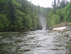
The Capilano River
Looking downwards from the top of the Cleveland Dam
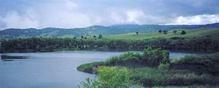
Capilano Lake, as seen from the top of the Cleveland Dam
The Rogue River in southwestern Oregon in the United States flows about 215 miles (346 km) in a generally westward direction from the Cascade Range to the Pacific Ocean. Known for its salmon runs, whitewater rafting, and rugged scenery, it was one of the original eight rivers named in the Wild and Scenic Rivers Act of 1968. Beginning near Crater Lake, which occupies the caldera left by the explosive volcanic eruption and collapse of Mount Mazama, the river flows through the geologically young High Cascades and the older Western Cascades, another volcanic province. Further west, the river passes through multiple exotic terranes of the more ancient Klamath Mountains. In the Kalmiopsis Wilderness section of the Rogue basin are some of the world's best examples of rocks that form the Earth's mantle. Near the mouth of the river, the only dinosaur fragments ever discovered in Oregon were found in the Otter Point Formation, along the coast of Curry County.
The Cleveland Dam is a 91-metre high (299 ft) concrete dam at the head of the Capilano River in Upper Capilano, North Vancouver, British Columbia, Canada that holds back Capilano Lake, also known as Capilano reservoir. Part of the Capilano River Regional Park, it stores a portion of the Lower Mainland's drinking water. It captures water from one of the three Metro Vancouver watersheds. Construction was started in 1951 and completed in 1954.
The Folsom Lake State Recreation Area surrounds Folsom Lake in the foothills of the Sierra Nevada. The majority of it is owned by the U.S. Bureau of Reclamation and is managed by the California Department of Parks and Recreation. It is located near the city of Folsom, California, about 25 miles (40 km) east of Sacramento.
Oatka Creek is the third longest tributary of the Genesee River, located entirely in the Western New York region of the U.S. state of New York. From southern Wyoming County, it flows 58 miles (93 km) to the Genesee near Scottsville, draining an area of 215 square miles (560 km2) that includes all or part of 23 towns and villages in Wyoming, Genesee, Livingston and Monroe counties as well. Its name means "leaving the highlands" or "approaching an opening" in Seneca.
The District of North Vancouver is a district municipality in British Columbia, Canada, situated north of the city of Vancouver across the Burrard Inlet. It surrounds the respective City of North Vancouver on three sides, and the remaining fellow North Shore municipality of West Vancouver on the other, and is part of the Metro Vancouver Regional District.
The Coquitlam River is a tributary of the Fraser River in the Canadian province of British Columbia. The river's name comes from the word Kʷikʷəƛ̓əm which translates to "Red fish up the river". The name is a reference to a sockeye salmon species that once occupied the river's waters.
The Capilano River flows from north to south through the Coast Mountains on the North Shore of the Burrard Inlet between British Columbia's district municipalities of West Vancouver and North Vancouver and empties into Burrard Inlet, opposite Stanley Park. The river is one of three primary sources of drinking water for residents of Greater Vancouver, and flows through the Capilano watershed. The Cleveland Dam, built in 1954, impounds a reservoir for this purpose. The entire area of the reservoir and watershed area upstream of the dam is closed to the public to ensure the quality of the drinking water. Prior to construction of the Cleveland Dam, the Capilano River deposited large amounts of sediment into Burrard Inlet. A dredge was needed to remove this sediment build-up in order to keep Burrard Inlet open for ship traffic.
Lake Pleasant Regional Park is a large outdoors recreation area straddling the Maricopa and Yavapai county border northwest of Phoenix, Arizona. The park is located within the municipal boundaries of Peoria, Arizona, and serves as a major recreation hub for the northwest Phoenix metropolitan area.
The North Shore Mountains are a mountain range overlooking Vancouver in British Columbia, Canada. Their southernmost peaks are visible from most areas in Vancouver and form a distinctive backdrop for the city.
Three Rivers Park District is a special park district serving the suburban areas of the Twin Cities including suburban Hennepin, Carver, Dakota, Scott, and Ramsey counties. Three Rivers's mission is "To promote environmental stewardship through recreation and education in a natural resources-based park system." Three Rivers operates twenty parks and ten regional trails, with at least two more regional trails planned. Nearly seven million people visit Three Rivers facilities each year. It has over 27,000 acres (11,000 ha) of parks and trails.
Alameda Creek is a large perennial stream in the San Francisco Bay Area. The creek runs for 45 miles (72 km) from a lake northeast of Packard Ridge to the eastern shore of San Francisco Bay by way of Niles Canyon and a flood control channel. Along its course, Alameda Creek provides wildlife habitat, water supply, a conduit for flood waters, opportunities for recreation, and a host of aesthetic and environmental values. The creek and three major reservoirs in the watershed are used as water supply by the San Francisco Public Utilities Commission, Alameda County Water District and Zone 7 Water Agency. Within the watershed can be found some of the highest peaks and tallest waterfall in the East Bay, over a dozen regional parks, and notable natural landmarks such as the cascades at Little Yosemite and the wildflower-strewn grasslands and oak savannahs of the Sunol Regional Wilderness. After an absence of half a century, ocean-run steelhead trout are able to return to Alameda Creek to mingle with remnant rainbow trout populations. Completion of a series of dam removal and fish passage projects, along with improved stream flows for cold-water fish and planned habitat restoration, enable steelhead trout and Chinook salmon to access up to 20 miles (32 km) of spawning and rearing habitat in Alameda Creek and its tributaries. The first juvenile trout migrating downstream from the upper watershed through lower Alameda Creek toward San Francisco Bay was detected and documented in April 2023.
Capilano Lake is a manmade lake located in the District of North Vancouver and West Vancouver in British Columbia, Canada.
The Seymour River is a river in North Vancouver, British Columbia which is notable for being several degrees warmer than other streams and lakes in the area. This is due to it being fed from a large reservoir backed up behind a dam from which a constant flow of water is released. The upper portion of the river and the reservoir are part of the Seymour watershed, controlled by Metro Vancouver.
Senecaville Lake is a reservoir in Guernsey and Noble Counties, Ohio. It is located approximately 13 miles (21 km) southeast of Cambridge near the village of Senecaville, Ohio. The lake is popular among recreation and fishing enthusiasts. It is often referred to locally as Seneca Lake.
Kanaka Creek Regional Park is a regional park of the Greater Vancouver Regional District, located in the city of Maple Ridge, British Columbia, flanking both sides of Kanaka Creek from its confluence with the Fraser River just east of Haney and extending approximately 11 km up the creek to just south of the community of Webster's Corners. The Maple Ridge Fairgrounds are just east of the lower regions of the park, beyond them is the community of Albion. Derby Reach Regional Park is just across the Fraser in Langley.
Marsh Creek is a stream in east Contra Costa County, California in Northern California which rises on the eastern side of Mount Diablo and flows 30 miles (48 km) to the Sacramento–San Joaquin River Delta at Oakley, California, near Big Break Regional Shoreline. The creek flows through Marsh Creek State Park (California), where water is impounded to form Marsh Creek Reservoir, then through the city of Brentwood, California.
Nanaimo River is a river on Vancouver Island, British Columbia, Canada, located near the city of Nanaimo on the island's east coast. Its headwaters are in the Vancouver Island Ranges of central Vancouver Island and its mouth, the Nanaimo River estuary, is at the south end of Nanaimo Harbour in the Strait of Georgia. The estuary is part of the Pacific Estuary Conservation Program.
Lynn Headwaters Regional Park is an area of North Vancouver, British Columbia, and is the largest of twenty-three regional parks in Metro Vancouver. At 9,216.5 acres (3,729.8 ha), the park boasts a variety of trails for hikers, including easy, intermediate, and challenging. The trails are colour-coded and range from 3 kilometres (1.9 mi) to 21.4 kilometres (13.3 mi). Bikes and dogs are allowed on select trails.
Breakneck Brook, sometimes Breakneck Valley Brook, is a 1.7-mile-long (2.8 km) tributary of the Hudson River located entirely in the Putnam County town of Philipstown, New York, United States. It rises at Surprise Lake and flows southwest towards the Hudson from there, mostly through Hudson Highlands State Park. The name comes from Breakneck Ridge to its north.
The Metro Vancouver watersheds, also known as the Greater Vancouver watersheds, supply potable water to approximately 2.7 million residents in the Lower Mainland of British Columbia. They provide tap water to a land area covering more than 2,600 square kilometres (1,000 sq mi), serving a total of 21 member municipalities, one electoral district, and one treaty First Nation. From west to east, the watersheds are the Capilano, the Seymour, and the Coquitlam. They are located in the North Shore Mountains and Coquitlam Mountain, respectively. Each watershed possesses a reservoir for water storage purposes, under the control of Metro Vancouver. The reservoirs are supplied by about 3.5 metres (11 ft) of rain and 4.5 metres (15 ft) of snowpack annually. Two additional off-catchment areas under control of Metro Vancouver contribute to the water supply. The watersheds have a long history of controversies surrounding logging, highway development, and salmon run conservation.
This page is based on this Wikipedia article Text is available under the CC BY-SA 4.0 license; additional terms may apply. Images, videos and audio are available under their respective licenses.