The list of provincial parks of the Okanagan contains the provincial parks located within this geographic region of the province of British Columbia. It includes parks from the three regional districts of Central Okanagan, North Okanagan and Okanagan-Similkameen. These parks are administered by BC Parks under the jurisdiction of the Ministry of Environment and Climate Change Strategy.
![]() Media related to Provincial Parks of British Columbia at Wikimedia Commons
Media related to Provincial Parks of British Columbia at Wikimedia Commons

Kalamalka Lake is a large lake in the interior plateau of southern central British Columbia, Canada, east of Okanagan Lake. The lake is located approximately 4 kilometres (2.5 mi) south of the city of Vernon and is its main drinking water supply. The lake is named after the Okanagan First Nation chief who occupied its northern shores.

Okanagan Mountain Provincial Park is a provincial park within the Okanagan-Similkameen Regional District of British Columbia, Canada, focused on the mountain of the same name and located on the east side of Okanagan Lake, opposite Peachland and immediately south of the City of Kelowna. The park is one of the largest in the area, covering 110.38 square kilometres (42.62 sq mi). Most of the park is only accessible by foot, horseback, bicycle, or boat as motor vehicle access is restricted to BC Parks staff and technicians servicing the three telecommunications towers in the park.

Bear Creek Provincial Park is a provincial park in British Columbia, Canada. It is situated on the west side of the Okanagan Lake and is northwest of the city of Kelowna. It was established on April 19, 1981, and was expanded to its current size of 178 hectares on May 12, 1988.

Browne Lake Provincial Park is a provincial park in British Columbia, Canada, located 22 km east-southeast of Kelowna in the Okanagan Highland, near Big White Ski Resort and between the heads of Hydraulic and Grouse Creeks.

Vaseux Lake Provincial Park is a provincial park located along the northeastern shore of Vaseux Lake in the Okanagan region of British Columbia, Canada. The park is situated 4 km south of Okanagan Falls on Highway 97 in the south Okanagan. The park plays a key role in educating and providing access to important conservation values and has a responsibility to maintain these activities.

Diana Lake Provincial Park is a 233 hectares provincial park located 16 kilometres east of the city of Prince Rupert in the North Coast Regional District of British Columbia, Canada. The park was established by BC Parks in 1980.

Darke Lake Provincial Park is a provincial park in British Columbia, Canada located west of Okanagan Lake, southwest of the town of Peachland in that province's Okanagan region. The park is approximately 1,470 hectares in size and was established in 1968 as a provincial park Darke Lake, also mapped historically as Fish Lake, is northwest of Summerland and is named after Silas Robert Darke, an early settler in the 1890s. In 1941 Howard Clark bought Fish Lake from Clyde Stewart. He was a hunting and fishing guide that ran the camp, as well as raised four children with his wife Hazel. The children were Betty, Roger, Dale & Audrey. In 1959 he sold it to Jake and Betty Enns.
Ellison Provincial Park is a provincial park in British Columbia, Canada, located on the east side of Okanagan Lake to the south of the city of Vernon. The park contains approximately 219 acres (0.89 km2) of land, 200 ha. of it upland, 19 ha. of it foreshore.
Graystokes Provincial Park is a provincial park located on the border between the regional districts of Central Okanagan and North Okanagan in south-central British Columbia. It was established on 18 April 2001 to protect a large area of the ecologically diverse Okanagan Highland east of the Okanagan Valley.

sw̓iw̓s Provincial Park is a provincial park in British Columbia, Canada, located on the west side of Osoyoos Lake in the town of Osoyoos, which is on the Canada-United States border at the southern end of the Okanagan region of British Columbia. Approximately 38 hectares in size, the park was originally created in 1939. The name was changed from Haynes Point to sw̓iw̓s, the original Okanagan (Syilx'tsn) name for the region, meaning "narrowing of the waters".
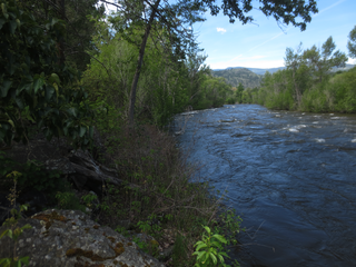
Inkaneep Provincial Park is a provincial park near Oliver, British Columbia, Canada, located just south of the town of Okanagan Falls. The park contributes to the protection of critical riparian values on the Okanagan River. The park is popular with naturalists, particularly bird-watchers. First Nations have identified the river and riparian area of the park as very important contributor to the long-term viability of the Okanagan River salmon run.

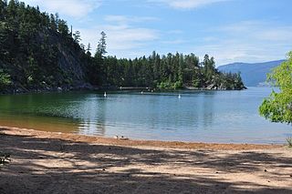
Kalamalka Lake Provincial Park and Protected Area is a provincial park in Coldstream, British Columbia, Canada. Located within the Okanagan region, the park encompasses a land area of about 978 hectares of pristine natural areas in the North Okanagan Regional District. Kalamalka Lake Provincial Park and Protected Area adopted its current name from Kalamalka Lake, for which it is located on its shore. During the process of entering summer, calcium carbonate forms crystals that reflect sunlight and create the vivid blue and green colours. Temperature changes in the fall and the spring sometimes create ribbons of deep blue colour in the lake, seen from the park.

Myra-Bellevue Provincial Park is a provincial park in British Columbia, Canada, located in the Okanagan Highland east of Kelowna. It was established to protect the full elevational range of the North Okanagan Basin and North Okanagan Highlands ecosections.
Okanagan Falls Provincial Park, now officially named sx̌ʷəx̌ʷnitkʷ Provincial Park, is a provincial park in British Columbia, Canada, located within the traditional territory of the Osoyoos Indian Band. Since time immemorial, the Osoyoos Indian Band's Okanagan ancestors have inhabited and cared for the lands and waters in their traditional territory. The park is also located within the town of Okanagan Falls, protecting the area around the waterfall of the same name, which lies below the outlet of Skaha Lake in the course of the Okanagan River.
Okanagan Lake Provincial Park is a provincial park in British Columbia, Canada. Established in 1955, the park covers a total area of 98 hectares.
The Okanagan Highland is an elevated hilly plateau area in British Columbia, Canada, and the U.S. state of Washington. Rounded mountains with elevations up to 8,000 ft (2,400 m) above sea level and deep, narrow valleys are characteristic of the region.

Vaseux Lake is a shallow freshwater lake located along the course of the Okanagan River in the Okanagan Valley of British Columbia, Canada.

Skaha Bluffs Provincial Park is a provincial park in British Columbia, Canada. Skaha Bluffs lies within the asserted territory of the Okanagan Nation Alliance. World-class climbing opportunities are found at Skaha Bluffs, recreational climbing has been occurring in the area since the 1980s.


