
Olympic National Park is a national park of the United States located in Washington, on the Olympic Peninsula. The park has four regions: the Pacific coastline, alpine areas, the west-side temperate rainforest, and the forests of the drier east side. Within the park there are three distinct ecosystems, including subalpine forest and wildflower meadow, temperate forest, and the rugged Pacific coast.
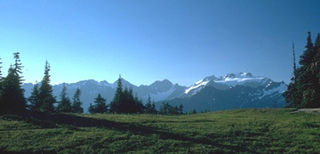
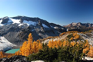
The Olympic Mountains are a mountain range on the Olympic Peninsula of the Pacific Northwest of the United States. The mountains, part of the Pacific Coast Ranges, are not especially high – Mount Olympus is the highest summit at 7,980 ft (2,432 m); however, the eastern slopes rise precipitously out of Puget Sound from sea level, and the western slopes are separated from the Pacific Ocean by the low-lying 20 to 35 km wide Pacific Ocean coastal plain. These densely forested western slopes are the wettest place in the 48 contiguous states. Most of the mountains are protected within the bounds of Olympic National Park and adjoining segments of the Olympic National Forest.
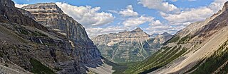
Kootenay National Park is a national park of Canada in southeastern British Columbia. The park consists of 1,406 km2 (543 sq mi) of the Canadian Rockies, including parts of the Kootenay and Park mountain ranges, the Kootenay River and the entirety of the Vermilion River. While the Vermilion River is completely contained within the park, the Kootenay River has its headwaters just outside the park boundary, flowing through the park into the Rocky Mountain Trench and eventually joining the Columbia River. The park ranges in elevation from 918 m (3,012 ft) at the southwestern park entrance to 3,424 m (11,234 ft) at Deltaform Mountain.

The Chequamegon–Nicolet National Forest is a 1,530,647-acre (6,194.31 km2) U.S. National Forest in northern Wisconsin in the United States. Due to logging in the early part of the 20th century, very little old growth forest remains. Some of the trees there were planted by the Civilian Conservation Corps in the 1930s. The national forest land trees and vegetation are part of the North Woods Ecoregion that prevails throughout the upper Great Lakes region.

The Monongahela National Forest is a national forest located in the Allegheny Mountains of eastern West Virginia, US. It protects over 921,000 acres of federally managed land within a 1,700,000 acres proclamation boundary that includes much of the Potomac Highlands Region and portions of 10 counties.

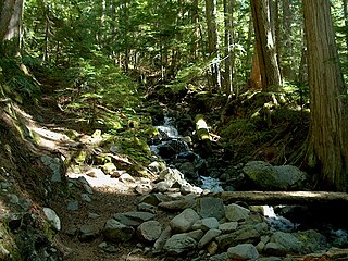
Lynn Canyon Park is a municipal park in the District of North Vancouver, British Columbia. When the park officially opened in 1912 it was only 12 acres (4.9 ha) in size, but it now encompasses 617 acres (250 ha). The park has many hiking trails of varying length and difficulty. The Baden-Powell Trail passes through the park crossing over the Lynn Canyon Suspension Bridge. Due to its natural landscape many TV series such as Stargate SG-1 and Stargate Atlantis used the area for filming.
Elk Lakes Provincial Park is a provincial park in southeastern British Columbia, Canada, located west of the continental divide. It is located adjacent to Height of the Rockies Provincial Park and is about 104 kilometers north of Sparwood. The park features sub-alpine landscapes, remnant glaciers, rugged peaks and productive lakes. Much of the park is above treeline and features several prominent mountains including Mount Fox, Mount Aosta, Mount McCuaig, and Mount Elkan. The Petain, Castelnau, Nivelle, and Elk Glaciers lie on the northeastern edge of the park. The following lakes are also present inside park boundaries: Upper and Lower Elk Lake, Frozen Lake, Fox Lake, Cadorna Lake, and Abruzzi Lake. Below the treeline, the park features mature growth forests of alpine fir, Engelmann spruce, and lodgepole pine. These trees are also intermingled with juniper, twinberry, false azalea, white rhododendron, and buffalo berry. The wildlife of the area includes Beaver, Snowshoe Hare, Red Squirrel, white-tailed deer, moose, and many varieties of birds.

Little Qualicum Falls Provincial Park is a provincial park in British Columbia, Canada, on central Vancouver Island, that encompasses the entire southern shore of Cameron Lake. The Island Rail Corridor line to Port Alberni passes through the park.

Mount Assiniboine Provincial Park is a provincial park in British Columbia, Canada, located around Mount Assiniboine.

The Purcell Wilderness Conservancy is a provincial park in British Columbia, Canada. It was established in 1974, and encompasses six large drainages in the Purcell Mountains in the southeast of the province. It contains high peaks, alpine meadows and ridges, deep creek and river valleys, and hot springs at Dewar Creek.

Strathcona Provincial Park is the oldest provincial park in British Columbia, Canada, and the largest on Vancouver Island. Founded in 1911, the park was named for Donald Alexander Smith, 1st Baron Strathcona and Mount Royal, a wealthy philanthropist and railway pioneer. It lies within the Strathcona Regional District. The Clayoquot Sound Biosphere Reserve, established in 2000, includes three watersheds in the western area of the park.
Tweedsmuir South Provincial Park is a provincial park covering parts of the eastern Kitimat Ranges, northern Pacific Ranges, and the Rainbow Range in British Columbia, Canada. It was established on May 21, 1938 in the western interior of the province, to protect its important natural features. The park hosts a variety of recreation activities for visitors. This park encompasses a range of diverse species in this park including bears, moose, and various fish. There are also a few at risk species in this park.
British Columbia mainland coastal forests is a temperate coniferous forest ecoregion the Pacific coast of North America, as defined by the World Wildlife Fund (WWF) categorization system.
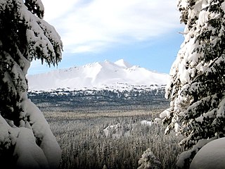
The Diamond Peak Wilderness in the U.S. state of Oregon is a wilderness area straddling the Cascade crest and includes the Diamond Peak volcano. It is located within two National Forests - the Willamette National Forest on the west and the Deschutes National Forest on the east.

Duck Mountain Provincial Park is a provincial park, located in the Canadian province of Saskatchewan 14 kilometres (8.7 mi) east of the town of Kamsack and stretches about 12 kilometres (7.5 mi) eastward to the Saskatchewan / Manitoba boundary. The park covers approximately 150 km2 (58 sq mi). Road access to the park is via Highway 57, which connects Saskatchewan Highway 5 to Manitoba Highway 83.
The Ecology of the North Cascades is heavily influenced by the high elevation and rain shadow effects of the mountain range. The North Cascades is a section of the Cascade Range from the South Fork of the Snoqualmie River in Washington, United States, to the confluence of the Thompson and Fraser Rivers in British Columbia, Canada, where the range is officially called the Cascade Mountains but is usually referred to as the Canadian Cascades. The North Cascades Ecoregion is a Level III ecoregion in the Commission for Environmental Cooperation's classification system.
The Central Pacific coastal forests is a temperate coniferous forest ecoregion located in the Canadian province of British Columbia and the U.S. states of Oregon and Washington, as defined by the World Wildlife Fund (WWF) categorization system.

The ecology of the Rocky Mountains is diverse due to the effects of a variety of environmental factors. The Rocky Mountains are the major mountain range in western North America, running from the far north of British Columbia in Canada to New Mexico in the southwestern United States, climbing from the Great Plains at or below 1,800 feet (550 m) to peaks of over 14,000 feet (4,300 m). Temperature and rainfall varies greatly also and thus the Rockies are home to a mixture of habitats including the alpine, subalpine and boreal habitats of the Northern Rocky Mountains in British Columbia and Alberta, the coniferous forests of Montana and Idaho, the wetlands and prairie where the Rockies meet the plains, a different mix of conifers on the Yellowstone Plateau in Wyoming, the montane forests of Utah, and in the high Rockies of Colorado and New Mexico, and finally the alpine tundra of the highest elevations.

The White Goat Wilderness Area is a provincially designated wilderness area in the Canadian Rockies of Alberta. It was established in 1961 and it, as one of the three wilderness areas of Alberta, has the strictest form of government protection available in Canada. All development is forbidden and only travel by foot is permitted. Hunting and fishing are not allowed. The other two wilderness areas are Ghost River Wilderness Area and Siffleur Wilderness Area and together the three areas total 249,548.80 acres (100,988.82 ha).

The Central British Columbia Mountain forests is a temperate coniferous forest ecoregion in north-central British Columbia, as defined by the World Wildlife Fund (WWF) categorization system.


