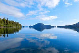
Pacific Rim National Park Reserve is a 511 km2 (197 sq mi) national park located in British Columbia, Canada, which comprises three separate regions: Long Beach, the Broken Group Islands, and the West Coast Trail. Its the Pacific Coast Mountains, are characterized by rugged coasts and temperate rainforests.

Haida Gwaii is an archipelago located between 55–125 km (34–78 mi) off the northern Pacific coast of Canada. The islands are separated from the mainland to the east by the shallow Hecate Strait. Queen Charlotte Sound lies to the south, with Vancouver Island beyond. To the north, the disputed Dixon Entrance separates Haida Gwaii from the Alexander Archipelago in the U.S. state of Alaska.

The ancient murrelet is a bird in the auk family. The English term "murrelet" is a diminutive of "murre", a word of uncertain origins, but which may imitate the call of the common guillemot. Ancient murrelets are called "ancient" because they have grey on the back like a shawl, as worn by the elderly.

Gwaii Haanas National Park Reserve, National Marine Conservation Area, and Haida Heritage Site, usually referred to simply as Gwaii Haanas, is located in southernmost Haida Gwaii, 130 kilometres off the mainland of British Columbia, Canada. Gwaii Haanas protects an archipelago of 138 islands, the largest being Moresby Island and the southernmost being Kunghit Island. "Gwaii Haanas" means "Islands of Beauty" in X̱aayda kíl, the language of the Haida people.

Daajing Giids, known as Queen Charlotte City from 1891–2022, is a village municipality in the Haida Gwaii archipelago in the province of British Columbia, Canada. It is located on the southern end of Graham Island at Skidegate Inlet and is a member municipality of the North Coast Regional District.
Moresby Island is a large island that forms part of the Haida Gwaii archipelago in British Columbia, Canada, located at 52°45′00″N131°50′00″W. It is separated by the narrow Skidegate Channel from the other principal island of the group to the north, Graham Island.

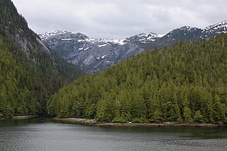
Lyell Island, known also in the Haida language as Athlii Gwaii, is a large island in the Haida Gwaii archipelago on the North Coast of British Columbia, Canada. The island is a part of the Gwaii Haanas National Park Reserve and Haida Heritage Site.
The Pacific Maritime Ecozone, as defined by the Commission for Environmental Cooperation (CEC), is a Canadian terrestrial ecozone, spanning a strip approximately 200 kilometres wide along the British Columbia Coast, then narrowing along the border with Alaska. It also includes all marine islands of British Columbia and a small portion of the southwestern corner of the Yukon. Fourteen ecoregions comprise the Ecozone, ranging from the Mount Logan Ecoregion in the north to the Cascade Ecoregion and Lower Mainland Ecoregion in the south.

Anthony Island is an island located in the southern part of Haida Gwaii, off the North Coast of British Columbia, Canada, to the west of Kunghit Island, the archipelago's southernmost. Anthony Island is noted for being the location of the ruins of SkungWai or SG̱ang Gwaay Llnaagay, commonly called Ninstints after the reigning mid-19th Century chief there. SG̱ang Gwaay Llnagaay was a major village of the Kunghit Haida people.
SG̱ang Gwaay Llanagaay, commonly known by its English name Ninstints, is a village site of the Haida people and part of the Gwaii Haanas National Park Reserve and Haida Heritage Site on Haida Gwaii on the North Coast of British Columbia, Canada.
Hotspring Island, originally named in English as Volcanic Island and known in the Haida language as G̱andll K'in Gwaayaay ("Hot-Water-Island"), is a small island near the southeast coast of Lyell Island in the Haida Gwaii archipelago of the North Coast of British Columbia, Canada. The island's names derive from a hot spring located on its southwestern end, the temperature of which has been measured at 162 °F (72 °C). The island is part of Gwaii Haanas National Park Reserve and Haida Heritage Site and is supervised by the Haida Gwaii Watchmen.

The Pacific North Coast Integrated Management Area is one of five Large Ocean Management Areas (LOMAs), areas of high ecological, social and economic importance, that have been identified by Fisheries and Oceans Canada (DFO) as priority regions for marine planning as part of Canada’s Oceans Action Plan.

Hlk'yah G̱awG̱a, also known as Windy Bay, is located on Athlii Gwaii in southern Haida Gwaii, British Columbia. The site was historically the location of a Haida village named Hlk'yah Llnagaay, meaning Peregrine Falcon Town in English. In the 1980s, Hlk'yah G̱awG̱a was the focus of a series of lawsuits and protests opposing clearcut logging on the island. These demonstrations were the impetus for the signing of the Gwaii Haanas Agreement of 1993 and the creation of the Gwaii Haanas National Park Reserve, National Marine Conservation Area Reserve, and Haida Heritage Site.

Tanu is a traditional Haida village site located on Tanu Island, Haida Gwaii, opposite of Kung'a Island in Laskeek Bay, within the Gwaii Haanas National Park Reserve and Haida Heritage Site.
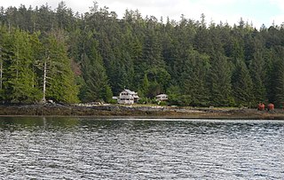
Rose Harbour is an unincorporated settlement on the north coast of Kunghit Island, on the south shore of the Houston Stewart Channel, in Haida Gwaii. It is within the bounds of Gwaii Haanas National Park Reserve and Haida Heritage Site. It is the only privately-owned property within Gwaii Haanas.
Kung Jaadee is a traditional Haida storyteller, singer, drummer, teacher, and children's book author from the village of Old Massett, Haida Gwaii in Northern British Columbia, Canada.
Duu Guusd Heritage Site/Conservancy is a heritage site and conservancy located in the northwest corner of Graham Island in the Haida Gwaii archipelago of British Columbia, Canada. It was established on March 23, 2008 to protect the ecological integrity and cultural importance of the region. The conservancy is part of an archipelago-wide system of protected areas that includes Gwaii Haanas National Park Reserve and Haida Heritage Site, Gwaii Haanas National Marine Conservation Area Reserve and Haida Heritage Site, and 17 other provincially protected areas.
Scott Islands Marine National Wildlife Area is a National Wildlife Area off the northwestern tip of Vancouver Island in the Canadian province of British Columbia. Covering an area of 11,570.65 km2 (4,467.45 sq mi), it is the second largest protected area in British Columbia after Offshore Pacific Seamounts and Vents Closure and is the largest national wildlife area in Canada.