Bruce Peninsula National Park

Last updated

Bruce Peninsula National Park
Grotto.jpg
The Grotto
Canada relief map 2.svg
Red pog.svg
Location of Bruce Peninsula National Park
Canada Southern Ontario relief location map.jpg
Red pog.svg
Location of Bruce Peninsula National Park
Location Ontario, Canada
Nearest city Tobermory
Coordinates 45°14′20″N81°36′51″W / 45.23889°N 81.61417°W / 45.23889; -81.61417
Area154 km2 (59 sq mi)
Established1987
Governing body Parks Canada

Bruce Peninsula National Park is a national park on the Bruce Peninsula in Ontario, Canada. Located on a part of the Niagara Escarpment, the park comprises 156 square kilometres and is one of the largest protected areas in southern Ontario, forming the core of UNESCO's Niagara Escarpment World Biosphere Reserve. [1] It was established in 1987 to protect the rock formations and shoreline of the Niagara Escarpment. [2] The park offers opportunities for many outdoor activities, including hiking, camping, and bird watching. The park has trails ranging in difficulty from easy to expert, and connects to the Bruce Trail. Bruce Peninsula National Park is known for its crystal clear blue waters, cobblestone beaches, rocky cliffs and karst formations. [2]

Contents

The park is open year-round [2] and offers visitors vistas to view either the sunrise or sunset, the rocks of the Niagara Escarpment, and the wildlife, which includes black bear, many species of birds, wild orchids, massasauga rattlesnake, and much more.

The park was the subject of a short film in 2011's National Parks Project , directed by Daniel Cockburn and scored by John K. Samson, Christine Fellows and Sandro Perri.

The Bruce Peninsula National Park has a weather and tourist information station CBPS-FM which operates at 90.7 FM. The station was launched in the mid-1990s. [3]

Bruce Peninsula National Park
This is a stopgap mapping solution, while attempts are made to resolve technical difficulties with {{ OSM Location map }}
Map of the northern end of the Bruce Peninsula. [4]

Geology

"The Grotto" at Bruce Peninsula National Park Bruce peninsula national park 4.JPG
"The Grotto" at Bruce Peninsula National Park

The Niagara Escarpment runs from near Rochester, New York, to Tobermory, then on to Manitoulin, St. Joseph Island and other islands located in northern Lake Huron where it turns westwards into the Upper Peninsula of northern Michigan, south of Sault Ste. Marie. The escarpment then extends southwards into Wisconsin following the Door Peninsula and then more inland from the western coast of Lake Michigan and Milwaukee ending northwest of Chicago near the Wisconsin-Illinois border. It forms the backbone of the Bruce Peninsula and shapes the northern boundary of most of the park and provides the park with some of its most spectacular scenery.

The rock of the escarpment is very old. Approximately 400 million years ago, this area was covered by a shallow tropical sea teeming with life in the form of plant-like animals, crustaceans, living corals and mollusks. It would have looked much like the present-day Great Barrier Reef of Australia. When the sea began to dry up, the minerals dissolved in it became more and more concentrated. Magnesium in the water was absorbed into the limestone, which then became a harder, slightly different sort of rock, called dolomite.

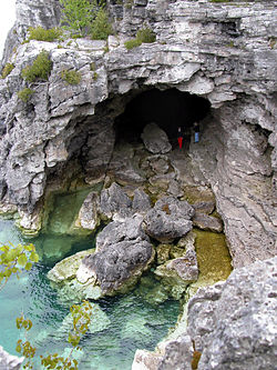
The harder dolomite forms much of the rock of the escarpment cliffs along Bruce Peninsula National Park's Georgian Bay shoreline. At Niagara Falls, the dolomite "caprock" is more resistant to erosion than the rock below it, creating the sculptured cliffs for which the area is famous. Since the last ice age, water levels in the region have undergone great changes. Softer limestone has been eroded away by water action, leaving magnificent overhanging cliffs at various points along the shore. These are the big attraction of the Cyprus Lake trails. Where erosion has cut more deeply, caves have been formed, such as the famed "Grotto" on the shore between the Marr Lake and Georgian Bay Trails. Great blocks of dolomite, undercut by wave action, have tumbled from the cliffs above and can be clearly seen below the surface of the deep, clean waters of Georgian Bay.

Climate

The park has a typical climate for lakeside Northern Ontario, though the surrounding bodies of Lake Huron moderate the temperates. The park has a humid continental climate (Dfb), with warm to hot summers and cool winters. [5] In the coastal northern parts of the peninsula, the climate is among the most temperate in Ontario. [6] The climate of the park is influenced by both Georgian Bay and Lake Huron, which significantly moderate temperatures. [7] :8 [6] As a result, they tend to prolong milder temperatures in the fall and cooler temperatures in spring. [8] :11 Summers are warm, with an average temperature of 16.8 °C (62.2 °F) while winters are cool, averaging −6.7 °C (19.9 °F). [8] :11 Summers are dominated by hot, humid air masses from the Pacific Ocean and the Gulf of Mexico. [7] :8 [8] :11 In winter, Pacific air masses predominate, bringing in warm and humid air although cold, dry air from the Arctic highs can occur, bringing in colder and drier conditions. [7] :8 [8] :11 Warm air masses coming from the Gulf of Mexico are rare during winter but are responsible for bringing January and February thaws. [7] :8 Spring and fall are characterized by complex weather patterns with contrasting and rapidly changing influences from the different regional air masses. [7] :8 The park receives 900 mm (35 in) of precipitation per year. [6] This is evenly distributed throughout the year with fall (September–November) being the wettest. [7] :16 [8] :11Precipitation is slightly lower than inland areas due to the limited influence that the narrow peninsula has when air masses travel over it compared to more interior locations. [7] :9

Fauna

Animals that inhabit this national park are chipmunks, squirrels, red foxes, raccoons, coyotes, black bears, porcupines, snowshoe hares, skunks, white-tailed deer, snakes and frogs. The park is an important habitat for massasauga rattlesnakes and one of the last places where they can be found. [9]

Flora

A variety of natural habitats are found in the park. These include mixed-wood forests, wetlands, alvars, talus slopes, and cliffs. The park is known for its wildflowers and has many species of algae, mosses, and lichen. [10] There are over 32 species of ferns and 34 species of orchids that are found in the park, including the eastern prairie fringed orchid, which is one of the rarest species native to North America. [6] The park hosts half of the world's dwarf lake iris, [11] which is considered a vulnerable species. [12] Forest cover includes eastern white cedar, spruce, fir, birch, poplar, maple, and beech. [6]

Activities

Bruce Peninsula National Park is open year-around with limited services during the off-season. The park offers many activities such as hiking, swimming, bouldering, camping, canoeing, and kayaking. During the winter season, activities such as cross-country skiing, snowshoeing, and winter camping are also available. Bruce Peninsula National Park was designated a Dark Sky Preserve in 2009 and is one of three places in southern Ontario where visitors can stargaze in naturally dark skies. [2]

Visitors' centre

In 2006, a new visitors' centre opened to serve Fathom Five National Marine Park and the Bruce Peninsula National Park. Designed by Andrew Frontini of Shore Tilbe Irwin + Partners, the CAD $7.82 million centre, approached by a boardwalk, features an information centre, reception area, exhibit hall and theatre. A 20-metre (66 ft) viewing tower was also constructed to provide visitors with aerial views of the surrounding park and Georgian Bay. The centre was designed with environmental sustainability in mind, receiving $224,000 from the Federal House in Order initiative for implementation of innovative greenhouse gas reduction technology. [1]

See also

Footnotes

  1. 1 2 [Canada Newswire; Parks Canada hosts opening ceremony for a new visitor centre at Fathom Five National Marine Park of Canada and Bruce Peninsula National Park of Canada; August 16, 2006]
  2. 1 2 3 4 National Geographic Guide to the National Parks of Canada (Second ed.). Washington, D.C.: National Geographic Partners. 2017. pp. 142–147.
  3. Decision CRTC 94-613, New low-power FM radio station at Bruce Peninsula National Park, CRTC , August 15, 1994
  4. "Bruce Peninsula National Park: Parks map". Parks Canada. Retrieved June 21, 2018.
  5. "Climate". Bruce Peninsula National Park. Retrieved 2022-01-15.
  6. 1 2 3 4 5 "Bruce Peninsula National Park of Canada/ Fathom Five National Marine Park of Canada" (PDF). Parks Canada. Retrieved 2 October 2016.
  7. 1 2 3 4 5 6 7 "Bruce Peninsula National Park Biophysical Survey" (PDF). Canadian Parks Service. Archived from the original (PDF) on 2 October 2016. Retrieved 2 October 2016.
  8. 1 2 3 4 5 Liipere, Sean (2014). "Chapter 2: The Bruce Peninsula" (PDF). Conservation and Stewardship Plan: Community Action on the Bruce Peninsula. Bruce Peninsula Biosphere Association. Retrieved 2 October 2016.
  9. Parks Canada Agency, Government of Canada (2018-01-17). "Massasauga Rattlesnake - Bruce Peninsula National Park". www.pc.gc.ca. Retrieved 2021-12-02.
  10. Parks Canada Agency, Government of Canada (2018-11-16). "Plants - Bruce Peninsula National Park". www.pc.gc.ca. Retrieved 2021-12-02.
  11. Parks Canada Agency, Government of Canada (2019-03-15). "Orchids - Bruce Peninsula National Park". www.pc.gc.ca. Retrieved 2021-12-05.
  12. "NatureServe Explorer 2.0". explorer.natureserve.org. Retrieved 2021-12-05.

Related Research Articles

<span class="mw-page-title-main">Manitoulin Island</span> Island in Lake Huron, Ontario, Canada

Manitoulin Island is an island in Lake Huron, located within the borders of the Canadian province of Ontario, in the bioregion known as Laurentia. With an area of 2,766 km2 (1,068 sq mi), it is the largest lake island in the world, large enough that it has over 100 lakes itself. In addition to the historic Anishinaabe and European settlement of the island, archaeological discoveries at Sheguiandah have demonstrated Paleo-Indian and Archaic cultures dating from 10,000 BC to 2,000 BC.

<span class="mw-page-title-main">Bruce Trail</span> Hiking trail in Ontario, Canada

The Bruce Trail is a hiking trail in southern Ontario, Canada, from the Niagara River to the tip of Tobermory, Ontario. The main trail is more than 890 km (550 mi) long and there are over 400 km (250 mi) of associated side trails. The trail mostly follows the edge of the Niagara Escarpment, one of the nineteen UNESCO World Biosphere Reserves in Canada. The land the trail traverses is owned by the Government of Ontario, local municipalities, local conservation authorities, private landowners, and the Bruce Trail Conservancy (BTC). The Bruce Trail is the oldest and longest marked hiking trail in Canada. Its name is linked to the Bruce Peninsula and Bruce County, through which the trail runs. The trail is named after the county, which was named after James Bruce, 8th Earl of Elgin who was Governor General of the Province of Canada from 1847 to 1854.

<span class="mw-page-title-main">Niagara Escarpment</span> Escarpment in Canada and the United States

The Niagara Escarpment is a long escarpment, or cuesta, in Canada and the United States that runs predominantly east–west from New York through Ontario, Michigan, Wisconsin, and into Illinois. The escarpment is the cliff over which the Niagara River plunges at Niagara Falls, for which it is named.

<span class="mw-page-title-main">Tobermory, Ontario</span> Community in Ontario, Canada

Tobermory is a small community located at the northern tip of the Bruce Peninsula, in the traditional territory of the Saugeen Ojibway Nation. Until European colonization in the mid-19th century, the Bruce Peninsula was home to the Saugeen Ojibway nations, with their earliest ancestors reaching the area as early as 7,500 years ago. It is part of the municipality of Northern Bruce Peninsula. It is 300 kilometres northwest of Toronto. The closest city to Tobermory is Owen Sound, 100 kilometres south of Tobermory and connected by Highway 6.

<span class="mw-page-title-main">Bruce County</span> County in Ontario, Canada

Bruce County is a county in Southwestern Ontario, Canada. It has eight lower-tier municipalities with a total 2016 population of 66,491. It is named for James Bruce, 8th Earl of Elgin and 12th Earl of Kincardine, the sixth Governor General of the Province of Canada. The Bruce name is also linked to the Bruce Trail and the Bruce Peninsula.

<span class="mw-page-title-main">Bruce Peninsula</span> Peninsula in Southern Ontario, Canada

The Bruce Peninsula is a peninsula in Ontario, Canada, that divides Georgian Bay of Lake Huron from the lake's main basin. The peninsula extends roughly northwestwards from the rest of Southwestern Ontario, pointing towards Manitoulin Island, with which it forms the widest strait joining Georgian Bay to the rest of Lake Huron. The Bruce Peninsula contains part of the geological formation known as the Niagara Escarpment.

<span class="mw-page-title-main">Fathom Five National Marine Park</span> National marine conservation area in Ontario, Canada

Fathom Five National Marine Park is a National Marine Conservation Area in the Georgian Bay part of Lake Huron, Ontario, Canada, that seeks to protect and display shipwrecks and lighthouses, and conserve freshwater ecosystems. Parks Canada has management plans for the aquatic and terrestrial ecosystems, with a multi-action plan for species that are at risk, including endemic species, the Monarch butterfly, the eastern ribbonsnake, and the eastern whip-poor-will. The aquatic ecosystems in the park are also of particular interest. Many fish, shellfish, amphibians, and eels are an attraction for naturalists in the park. Much of this wildlife is accessible to scuba divers and snorkellers in the park. The many shipwrecks make the park a popular scuba diving destination, and glass bottom boat tours leave Tobermory regularly, allowing tourists to see the shipwrecks without having to get wet. Additionally, there are three main popular hiking trails found within Fathom Five National Marine Park that provides visitors with views of old growth forests and the Georgian Bay. The Saugeen Ojibway Peoples have inhabited the Bruce Peninsula and the area that is now Fathom Five National Marine Park for thousands of years. This land provided for their communities and their people with the plethora of wildlife and plant life. They provide the local knowledge about Lake Huron and its ecological value to the reserve, park, and their overall livelihood. Parks Canada and Saugeen Ojibway People's collaboration is said to yield a benefit to both parties with regard to overall ecosystem knowledge.

<span class="mw-page-title-main">Wiarton</span> Community in Ontario, Canada

Wiarton is a community in the town of South Bruce Peninsula, Bruce County, Ontario, Canada. It is located at the western end of Colpoys Bay, an inlet off Georgian Bay, on the Bruce Peninsula.

<span class="mw-page-title-main">Snowbelt</span> Region in North America where heavy snowfall is common

The Snowbelt, Snow Belt, Frostbelt, or Frost Belt is the region near the Great Lakes in North America where heavy snowfall in the form of lake-effect snow is particularly common. Snowbelts are typically found downwind of the lakes, principally off the eastern and southern shores.

<span class="mw-page-title-main">Georgian Bay Islands National Park</span> National park in Ontario, Canada

Georgian Bay Islands National Park consists of 63 small islands or parts of islands in Georgian Bay, near Port Severn, Ontario. The total park area is approximately 13.5 km2 (5.2 sq mi). Prior to the creation of Fathom Five National Marine Park, Flowerpot Island was also a part of the park.

<span class="mw-page-title-main">The Massasauga Provincial Park</span> Provincial park in Ontario

The Massasauga Provincial Park is a provincial park in Parry Sound District, Ontario, Canada, stretching from the town of Parry Sound south to the Moon River. The park has an area of 131.05 km2 (50.60 sq mi).

<span class="mw-page-title-main">Lion's Head, Ontario</span> Community in Ontario, Canada

Lion's Head is a community in the municipality of Northern Bruce Peninsula, Bruce County, Ontario, Canada. It is located at the midway point of the Bruce Peninsula, about halfway between Owen Sound and Tobermory, just east of Ferndale on Bruce Road 9. Lion's Head is located on the 45th parallel north, halfway between the Equator and the North Pole. The town is named after the resemblance of a lion's profile in the rock formation of the Niagara Escarpment. The first post office opened in 1895.

<span class="mw-page-title-main">Rattlesnake Point (Canada)</span>

Rattlesnake Point is an eco-tourism area located in Milton, Ontario, Canada and is owned and operated by Conservation Halton. Spanning roughly one hundred square kilometres across and near the Niagara Escarpment in Halton Region, the Rattlesnake Point area is home to many golf courses, country markets and equestrian training and boarding facilities. It is a popular scouting area.

<span class="mw-page-title-main">Geography of Ontario</span> Geographical features of Ontario

Ontario is located in East/Central Canada. It is Canada's second largest province by land area. Its physical features vary greatly from the Mixedwood Plains in the southeast to the boreal forests and tundra in the north. Ontario borders Manitoba to the west, Hudson Bay and James Bay to the north, Quebec to the east, and the Great Lakes and the United States to the south. The province is named for Great Lake Ontario, an adaptation of the Iroquois word Onitariio, meaning "beautiful lake", or Kanadario, variously translated as "beautiful water". There are approximately 250,000 lakes and over 100,000 kilometres (62,000 mi) of rivers in the province.

<span class="mw-page-title-main">Geography of Hamilton, Ontario</span>

Hamilton is located on the western end of the Niagara Peninsula and wraps around the westernmost part of the Lake Ontario. Most of the city including the downtown section lies along the south shore. Situated in the geographic centre of the Golden Horseshoe, it lies roughly midway between Toronto and Buffalo. The two major physical features are Hamilton Harbour marking the northern limit of the city and the Niagara Escarpment running through the middle of the city across its entire breadth, bisecting the city into 'upper' and 'lower' parts.

The Short Hills Bench is a sub-appellation of the Niagara Peninsula.

<span class="mw-page-title-main">Beausoleil Island</span>

Beausoleil Island; Île Beausoleil; is an 8-kilometre (5.0 mi) long island in the municipality of Georgian Bay, District Municipality of Muskoka in Central Ontario, Canada. The island is named after Louis Beausoleil, a Métis settler whose 1819 homestead stood at the island's southern tip. The name of the island in the Huron-Wendat language is Skiondechiara which means "The land to appear floating afar". The name of the island in the Anishinaabemowin language is variously Pamedenagog, Baamidoonegog or Epenmindaagoog meaning “rocky place floating about the mouth of a river”. Located in the Thirty Thousand Islands in Georgian Bay on Lake Huron, it is the largest island in Georgian Bay Islands National Park and is the only place in the park where camping is allowed. Beausoleil Island is also part of the Georgian Bay Littoral UNESCO Biosphere reserve.

<span class="mw-page-title-main">Niagara Escarpment Biosphere Reserve</span> UNESCO Biosphere Reserve in Ontario, Canada

The Niagara Escarpment Biosphere Reserve is a UNESCO Biosphere Reserve located in Ontario, Canada. The reserve stretches 725 kilometres (450 mi) along the Niagara Escarpment from Lake Ontario to the tip of the Bruce Peninsula. The Escarpment corridor crosses two major biomes: needle leaf forests in the north and temperate broadleaf forest in the south.

Saugeen and Cape Croker Fishing Islands 1 is a First Nations reserve consisting of 89 islands in Lake Huron off the western coast of the Bruce Peninsula in Ontario. They extend north of Chief's Point 28 for 11 miles (18 km) up to Pike Bay. These islands are shared between the Chippewas of Nawash Unceded First Nation and Saugeen First Nation.

The Ontario Alliance of Climbers is an independent, provincial, volunteer, non-profit organization that works to keep climbing and bouldering areas open in Ontario, Canada. The organization's stated purpose is to help conserve access to climbing by advocating protection for the climbing environment, by resolving access issues as they arise, and by proactively engaging with and educating the climbing community.