Obabika River Provincial Park

Last updated
Obabika River Provincial Park
Canada Ontario relief location map.jpg
Red pog.svg
Location Ontario, Canada
Nearest town Temagami
Coordinates 47°12′58″N80°16′54″W / 47.2161°N 80.2817°W / 47.2161; -80.2817 Coordinates: 47°12′58″N80°16′54″W / 47.2161°N 80.2817°W / 47.2161; -80.2817 [1]
Area20,520 ha (79.2 sq mi) [2]
DesignationWaterway
Established1989
Named for Obabika River
Governing body Ontario Parks
www.ontarioparks.com/park/obabikariver

The Obabika River Provincial Park is a provincial park in Ontario, Canada, straddling across the boundaries of the Sudbury, Nipissing, and Timiskaming Districts. [1] While it is named after and includes the Obabika River, the bulk of the park extends north of Obabika Lake to the eastern boundary of Lady Evelyn-Smoothwater Provincial Park. [3]

Contents

The park was created in 1989 and expanded in 2002 to 205 square kilometres (79 sq mi). Highlights of the park include island-dotted lakes, meandering rivers, bedrock uplands and expansive wetlands, as well as a number of historic settlements and indigenous archaeological sites dating back 6000 years. It provides trails through the pristine Obabika Old-Growth Forest, providing nature exploration and wildlife viewing opportunities. [2] [3]

Permitted activities include canoe camping, fishing, hiking, hunting, and boating (albeit with restrictions). The canoe routes through the park are part of Temagami's 2,400 kilometres (1,500 mi) long network of portages and waterways. Many of these portages are traditional indigenous routes called "nastawgan", which link this park with adjacent parks, conservation reserves, and Crown land. [2] [4]

Description

The park can be divided into 4 areas, consisting of both wilderness (limited or no development) and natural environment (some development allowed to support the park's mission) zones:

It is an operational park requiring permits for camping. Facilities included 65 backcountry campsites. [2] Services provided are portage, campsite, and trail maintenance. [5]

Regional context

The park is part of a network of provincial parks and conservation reserves in the Temagami area. It forms a natural corridor between the adjacent Sturgeon River and Lady Evelyn-Smoothwater Provincial Parks. If established, it will also link to the proposed Lake Temagami Provincial Park. [5] Furthermore, it borders on Bob Lake Conservation Reserve, which protects some old growth pine forests and provides an alternate canoe route between Lake Temagami, Diamond, and Obabika Lakes. [7] Other adjacent conservation reserves are East Lady Evelyn Lake Conservation Reserve (protecting the northern part of Lady Evelyn Lake), [8] Sugar Lake Conservation Reserve (a large roadless area between the upper and lower basin of Lady Evelyn Lake), [9] and Jim Edwards Lake Conservation Reserve (includes the headwaters for the Lady Evelyn River watershed and old-growth pine stands). [10]

See also

Related Research Articles

Lake Abitibi Lake on Ontario / Quebec border, Canada

Lake Abitibi is a shallow lake in northeastern Ontario and western Quebec, Canada. The lake, which lies within the vast Clay Belt, is separated in two distinct portions by a short narrows, making it actually 2 lakes. Its total area is 931 square kilometres (359 sq mi), and net area 903 square kilometres (349 sq mi). The lake is shallow and studded with islands. Its shores and vicinity are covered with small timber.

Algonquin Provincial Park Protected area of Ontario

Algonquin Provincial Park is a provincial park located between Georgian Bay and the Ottawa River in Ontario, Canada, mostly within the Unorganized South Part of Nipissing District. Established in 1893, it is the oldest provincial park in Canada. Additions since its creation have increased the park to its current size of about 7,653 km2 (2,955 sq mi). The park is contiguous with several smaller, administratively separate provincial parks that protect important rivers in the area, resulting in a larger total protected area.

Spanish River (Ontario)

The Spanish River is a river in Algoma District, Sudbury District and Greater Sudbury in Northeastern Ontario, Canada. It flows 338 kilometres (210 mi) in a southerly direction from its headwaters at Spanish Lake and Duke Lake to its mouth at the North Channel of Lake Huron just outside the community of Spanish.

Amable du Fond River

The Amable du Fond River is a river in Nipissing District, in Northern Ontario, Canada.

Sturgeon River (Lake Nipissing)

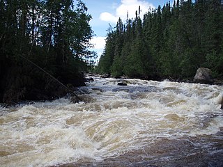
The Sturgeon River is a river that springs near Lady Evelyn-Smoothwater Provincial Park in the Timiskaming District in Ontario, Canada. It flows 230 kilometres (140 mi) in a mostly south-easterly direction through Sudbury and Nipissing Districts before it empties into Lake Nipissing on the north shore. The town of Sturgeon Falls is located on the river about 3 kilometres (1.9 mi) north of its mouth.

Lake Temagami Lake in Canada

Lake Temagami, formerly spelled as Lake Timagami, is a lake in Nipissing District in northeastern Ontario, Canada, situated approximately 80 km north of North Bay. The lake's name comes from Te-mee-ay-gaming, which means "deep water by the shore" in the Ojibwa language.

Mississagi Provincial Park

Mississagi Provincial Park is a natural environment-class park north of Elliot Lake, in Algoma District, Ontario, Canada. It lies on the Boland River, a tributary of the Little White River, which is a tributary of the Mississagi River. The park is accessed via Highway 639.

Ontario Parks is the Ontario government agency in Ontario, Canada, that protects significant natural and cultural resources in a system of parks and protected areas that is sustainable and provides opportunities for inspiration, enjoyment and education. The Ontario Parks system covers over 78,000 square kilometres (30,000 sq mi), which is about 10 percent of the province's surface area or the equivalent of an area approximately equal to Nova Scotia. It falls under the responsibility and mandate of the province's Ministry of the Environment, Conservation and Parks. It was formerly under the mandate of the Ministry of Natural Resources and Forestry.

The Obabika River is located in central Ontario, Canada. It is south of Lady Evelyn-Smoothwater Provincial Park and west of Lake Temagami, within Sudbury District. It flows from Obabika Lake in a south-westerly direction and drains into the Sturgeon River. The Obabika River is remote and surrounded by undeveloped wilderness.

Lady Evelyn-Smoothwater Provincial Park

Lady Evelyn-Smoothwater Provincial Park is a remote wilderness park in northeastern Ontario, Canada, near Lake Temagami. It is one of five provincial parks located in the Temagami area.

White Lake Provincial Park (Ontario) Provincial park in Ontario

White Lake Provincial Park is a park in the Thunder Bay District of Northern Ontario, Canada, along Highway 17, north of Lake Superior.
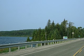
Temagami Municipality in Ontario, Canada

Temagami, formerly spelled as Timagami, is a municipality in northeastern Ontario, Canada, in the Nipissing District with Lake Temagami at its heart.
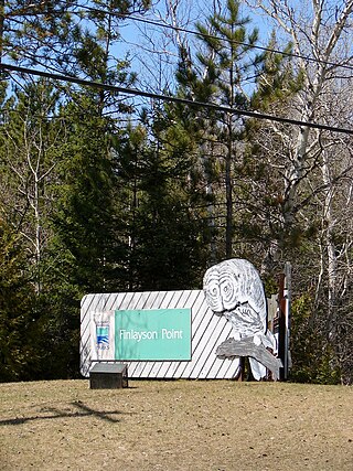
The Temagami River, formerly spelled as Timagami River, is a river in the Nipissing District of Ontario, Canada, in the Temagami region. Its source is Lake Temagami and flows through Cross Lake and Red Cedar Lake. It flows into the Sturgeon River at the community of River Valley.

The Temagami First Nation is located on Bear Island in the heart of Lake Temagami. The island is the second largest in Lake Temagami, after Temagami Island. Its community is known as Bear Island 1. Temagami First Nation (TFN) members are status Indians under the Indian Act that live on and off Bear Island.

Sturgeon River Provincial Park

The Sturgeon River Provincial Park is a provincial park in northern Ontario, Canada, that protects about 70 kilometres (43 mi) long section of the Sturgeon River and its banks, from Woods Lake to the Sudbury-Nipissing District boundary. It was established in 1989 and expanded in 2005. It protects outstanding water routes that provide recreational canoe camping opportunities. Other activities include hunting and fishing.

Obabika old-growth forest is an Eastern White Pine and Red Pine dominated old-growth forest at the north end of Obabika Lake, just west of the Temagami region of Ontario, Canada. At 2,400 hectares in size, it is commonly considered to be the largest remaining white pine dominated old-growth forest in the world. It is also sometimes called Chee-Skon Lake old-growth forest, or Wakimika Triangle old-growth forest. This area was slated for logging in 1989 and was protected largely as a result of a blockade on Red Squirrel Road in which 344 protestors were arrested, including future Ontario premier Bob Rae. The oldest trees in the Obabika old-growth forest are confirmed to be at least 375 years old, but a diversity of age classes occur in this forest. Another important feature of the area is the spirit rock, a column of rock on the shore of Chee-Skon Lake that is of spiritual significance to the Teme-Augama Anishnabai people.

Eastern forest–boreal transition Temperate broadleaf and mixed forest ecoregion in Canada and the United States

The eastern forest–boreal transition is a temperate broadleaf and mixed forests ecoregion of North America, mostly in eastern Canada. It is a transitional zone or region between the predominantly coniferous Boreal Forest and the mostly deciduous broadleaf forest region further south.

Chiniguchi Waterway Provincial Park

The Chiniguchi Waterway Provincial Park consists of 9,368 ha (36.17 sq mi) of protected wilderness along the Chiniguchi River, Maskinonge Lake, Kukagami Lake, Wolf Lake and Matagamasi Lake in the Sudbury District of Ontario, that includes 336 hectares of Forest Reserve. The park is one of the several provincial parks located in the Sudbury area. It is managed by Ontario Parks. It contains the largest stand of old growth Red Pines.

The Little White River is a river in the Unorganized North Part of Algoma District in Northeastern Ontario, Canada. It is in the Great Lakes Basin and is a left tributary of the Mississagi River.

The Makobe River is a river in northeastern Ontario, Canada. It is in the Saint Lawrence River drainage basin and is a left tributary of the Montreal River.

References

  1. 1 2 "Obabika River Provincial Park". Geographical Names Data Base . Natural Resources Canada . Retrieved 9 May 2022.
  2. 1 2 3 4 "Obabika River". www.ontarioparks.com. Ontario Parks. Retrieved 9 May 2022.
  3. 1 2 "Policy Report P1918: OBABIKA RIVER PROVINCIAL PARK (WATERWAY CLASS)". Crown Land Use Policy Atlas. Ministry of Natural Resources Ontario. 1 December 2012. Retrieved 9 May 2022.
  4. Wilson, Hap (1988). Temagami canoe routes (Rev. and updated ed.). Merrickville, Ontario: The Canadian Recreational Canoeing Association. ISBN   0969325819.
  5. 1 2 3 4 5 6 "Temagami Area Park Management Plan" (PDF). Ontario.ca. Ontario Parks. 2007. Retrieved 9 May 2022.
  6. Quinby, Peter (1993). "Old-growth eastern white pine forest: An endangered ecosystem" (PDF). Ancient Forest Exploration & Research. Ancient Forest Exploration & Research. Retrieved 11 May 2022.
  7. "Policy Report CR44: BOB LAKE CONSERVATION RESERVE". Crown Land Use Policy Atlas. Ministry of Natural Resources Ontario. 1 December 2012. Retrieved 10 May 2022.
  8. "Policy Report CR32: EAST LADY EVELYN LAKE CONSERVATION RESERVE". Crown Land Use Policy Atlas. Ministry of Natural Resources Ontario. 1 December 2012. Retrieved 10 May 2022.
  9. "Policy Report CR33: SUGAR LAKE CONSERVATION RESERVE". Crown Land Use Policy Atlas. Ministry of Natural Resources Ontario. 1 December 2012. Retrieved 10 May 2022.
  10. "Policy Report CR52: JIM EDWARDS LAKE CONSERVATION RESERVE". Crown Land Use Policy Atlas. Ministry of Natural Resources Ontario. 1 December 2012. Retrieved 10 May 2022.