Hiawatha National Forest is a 894,836-acre (362,127 ha) National Forest in the Upper Peninsula of the state of Michigan in the United States. Commercial logging is conducted in some areas. The United States Forest Service administers this National Forest; it is physically divided into two subunits, commonly called the Eastside 46°14′N84°50′W and Westside 46°08′N86°40′W.
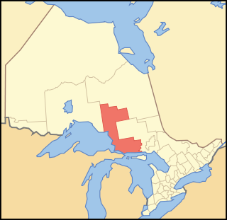
Algoma District is a district and census division in Northeastern Ontario in the Canadian province of Ontario.

Hamlin Beach State Park is a 1,287-acre (5.21 km2) state park located on the shore of Lake Ontario in the Town of Hamlin in Monroe County, New York, United States. The Lake Ontario State Parkway passes through the park.

The Batchawana River is a river in Algoma and Sudbury Districts of Ontario, Canada, which empties into Batchawana Bay on Lake Superior north of Sault Ste. Marie, Ontario.

Lake Superior Provincial Park is one of the largest provincial parks in Ontario, covering about 1,550 square kilometres (600 sq mi) along the northeastern shores of Lake Superior between Sault Ste. Marie and Wawa in Algoma District in Northeastern Ontario, Canada. Ontario Highway 17 now runs through the park. When the park was established by Ontario in 1944, there was no road access.

Marathon is a town in the Canadian province of Ontario, located in Thunder Bay District, on the north shore of Lake Superior north of Pukaskwa National Park.

Bon Echo Provincial Park is a provincial park in southeastern Ontario, Canada, approximately 6 kilometres (3.7 mi) north of Cloyne. The park is within township boundaries of both North Frontenac and Addington Highlands, roughly separated by Highway 41.
MacGregor Point Provincial Park is a park located on Lake Huron, off of Bruce Road 33 near Port Elgin, Ontario, Canada.

Disney's Fort Wilderness Resort & Campground is a themed camping resort located in the Magic Kingdom Resort Area at the Walt Disney World Resort in the U.S. state of Florida. It officially opened on November 19, 1971. The resort is situated adjacent to Bay Lake, near Disney's Wilderness Lodge. It also formerly contained Disney's River Country, a water park which closed on November 2, 2001.

The North Shore of Lake Superior runs from Duluth, Minnesota, United States, at the western end of the lake, to Thunder Bay and Nipigon, Ontario, Canada, in the north, to Sault Ste. Marie, Ontario in the east. The shore is characterized by alternating rocky cliffs and cobblestone beaches, with forested hills and ridges through which scenic rivers and waterfalls descend as they flow to Lake Superior.

Plumper Cove Marine Provincial Park is a provincial park in British Columbia, Canada. The park is located on the northwest shore of Keats Island in Howe Sound, northwest of Vancouver, British Columbia.

Neys Provincial Park is a natural environment-class provincial park on the north shore of Lake Superior, just west of Marathon, Ontario, Canada. This 5,383-hectare (13,300-acre) park includes the historic Coldwell Peninsula and the surrounding island system, consisting of Pic Island, Detention Island, and the Sullivan Islands.
Balsam Lake Provincial Park is a provincial park located in south-central Ontario, Canada, on Balsam Lake. The park is situated along the Trent-Severn Waterway, a few kilometres southwest of Coboconk. It is an all-seasons recreation area offering camping, boating and fishing, and while closed in winter it is also used for skiing and snowshoeing.

Pinery Provincial Park is a provincial park located on Lake Huron near Grand Bend, Ontario. It occupies an area of 25.32 square kilometres. It is a natural environment-class Provincial Park created to help preserve oak savannah and the beach dune ecology. It has 1,275 sites of which 404 have electrical hookups. These include the yurt camping area and the group camping sites.

Meadow Lake Provincial Park is a northern boreal forest provincial recreational park along the Waterhen and Cold Rivers in the Canadian province of Saskatchewan. The park was founded on 10 March 1959, is the largest provincial park in Saskatchewan, and encompasses over 25 lakes in an area of 1,600 km2 (620 sq mi). The park was named "Meadow Lake" after the city of Meadow Lake and Meadow Lake. The city and the lake are not in the park and are located about 40 kilometres (25 mi) south-east of the nearest park entrance, which is about 5 kilometres (3.1 mi) north of Dorintosh. The length of the park stretches about 113 kilometres (70 mi) from Cold Lake on the Saskatchewan / Alberta border in the west to the eastern shore of Waterhen Lake in the east.

Echo Valley Provincial Park is a provincial park in the Canadian province of Saskatchewan, located west of the town of Fort Qu'Appelle in the Qu'Appelle Valley between Echo Lake and Pasqua Lake in the RM of North Qu'Appelle No. 187. The three main roads to access the park are Highways 210, 56, and 727.

Ponderosa State Park is a public recreation area and state park occupying a peninsula in Payette Lake on the northeast edge of McCall in Valley County, Idaho, United States. The park's 1,515 acres (613 ha) include a second unit, called North Beach, located six miles (9.7 km) north of McCall at the northern extremity of the lake. Ponderosa is a popular park for day use and camping. In 2020, the park recorded 392,417 day users and 78,081 campers making it the 5th most visited state park in Idaho that year. There is a motor vehicle entry fee of $7.00 per vehicle, per day for both Idaho residents and non-residents. Idaho residents can purchase an Idaho State Parks Passport for $10 per vehicle, per year which will give them unlimited access to Ponderosa State Park and any other state park for the year.

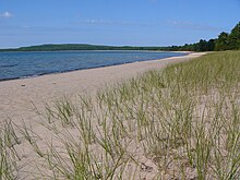
Sandy Islands Provincial Park is a non-operating park in the nature reserve class consisting of 2,553 hectares. It is located in the large Whitefish Bay, near the mouth of the smaller Batchawana Bay in Lake Superior near Sault Ste. Marie, Ontario. The islands have an elevation of 183 meters above sea level. There are two islands, North Sandy Island and South Sandy Island. When the weather is clear the islands are visible from Pancake Bay Provincial Park close to the horizon looking south. The park was created as a measure to protect the fragile ecology of these sand islands.
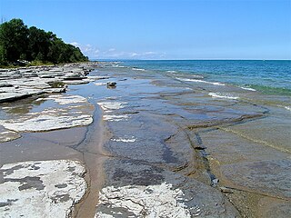
Craigleith Provincial Park was established in 1967 by Ontario Parks. It is a recreation-class provincial park created to help preserve historic oil shale beach. Craigleith Provincial Park is a small park located between Collingwood and Thornbury on the southern shores of Georgian Bay.
Great Blue Heron Provincial Park is a recreational park in the central region of the Canadian province of Saskatchewan in the boreal forest ecozone of Canada. It is adjacent to the eastern boundary of Prince Albert National Park, about 50 kilometres (31 mi) north of the city of Prince Albert. The provincial park was established in 2013 from two pre-existing provincial recreation sites – Emma Lake and Anglin Lake Recreation Sites – and the addition of a large tract of Crown land.