
The Saulteaux, otherwise known as the Plains Ojibwe, are a First Nations band government in Ontario, Manitoba, Saskatchewan, Alberta and British Columbia, Canada. They are a branch of the Ojibwe who pushed west. They formed a mixed culture of woodlands and plains Indigenous customs and traditions.

Lake of the Woods is a lake occupying parts of the Canadian provinces of Ontario and Manitoba and the U.S. state of Minnesota. Lake of the Woods is over 70 miles (110 km) long and wide, containing more than 14,552 islands and 65,000 miles (105,000 km) of shoreline. It is fed by the Rainy River, Shoal Lake, Kakagi Lake and other smaller rivers. The lake drains into the Winnipeg River and then into Lake Winnipeg. Ultimately, its outflow goes north through the Nelson River to Hudson Bay.

Gulf Islands National Park Reserve is a national park located on and around the Gulf Islands in British Columbia, Canada. In the National Parks System Plan, this park provides representation of the Strait of Georgia Lowlands natural region, the only place in Canada with a Mediterranean climate of dry, sunny summers and mild, wet winters, the result of a rain shadow effect from surrounding mountains between the region and the ocean. It has similar dominant vegetation as the Pacific Northwest, such as coastal Douglas-fir, western red cedar, shore pine, Pacific dogwood, bigleaf maple, and red alder, but also contains the northern extent of some of the more drought tolerant trees such as Garry oak and Arbutus. The park was created in 2003 as the fortieth national park. It covers 36 square kilometres (14 sq mi) of area on 16 islands and more than 30 islets, reefs and surrounding waters, making it the sixth smallest national park in Canada.

The Bruce Peninsula is a peninsula in Ontario, Canada, that divides Georgian Bay of Lake Huron from the lake's main basin. The peninsula extends roughly northwestwards from the rest of Southwestern Ontario, pointing towards Manitoulin Island, with which it forms the widest strait joining Georgian Bay to the rest of Lake Huron. The Bruce Peninsula contains part of the geological formation known as the Niagara Escarpment.
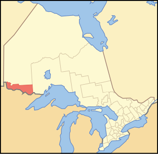
Rainy River District is a district and census division in Northwestern Ontario in the Canadian province of Ontario. It was created in 1885. It is the only division in Ontario that lies completely in the Central Time Zone, except for the township of Atikokan observing Eastern Standard Time year-round. Its seat is Fort Frances. It is known for its fishing and its location on the US border opposite International Falls, Minnesota, and Baudette, Minnesota.
Treaty 3 was an agreement entered into on October 3, 1873, by Chief Mikiseesis on behalf of the Ojibwe First Nations and Queen Victoria. The treaty involved a vast tract of Ojibwe territory, including large parts of what is now northwestern Ontario and a small part of eastern Manitoba, to the Government of Canada. Treaty 3 also provided for rights for the Waasaakode Anishinaabe and other Ojibwe, through a series of agreements signed over the next year. The treaty was modified in 1875 when Nicolas Chatelain negotiated an adhesion that created a reserve, surveyed as reserve 16A, for Metis families connected to Mikiseesis' Rainy Lake Band. Reserve 16A and the Rainy Lake Band reserve were unified in 1967.
Asubpeeschoseewagong First Nation is an Ojibwe First Nations band government who inhabit northern Kenora in Ontario, Canada. Their landbase is the 4,145 ha English River 21 Indian Reserve. It has a registered population of 1,595 as of October 2019, of which the on-reserve population was 971. As of October 2020, the community had a population of approximately 1,200. They are a signatory to Treaty 3.

Whiteshell Provincial Park is a provincial park in southeast Manitoba, approximately 120 kilometres (75 mi) east of the city of Winnipeg. The park is considered to be a Class II protected area under the IUCN protected area management categories. It is 275,210 hectares in size.
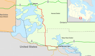
King's Highway 71, commonly referred to as Highway 71, is a provincially maintained highway in the Canadian province of Ontario. The 194-kilometre-long (121 mi) route begins at the Fort Frances–International Falls International Bridge in Fort Frances, continuing from US Highway 53 (US 53) and US 71 in Minnesota, and travels west concurrently with Highway 11 for 40 kilometres (25 mi) to Chapple. At that point, Highway 11 continues west while Highway 71 branches north and travels 154 kilometres (96 mi) to a junction with Highway 17 just east of Kenora. Highway 71 forms a branch of the Trans-Canada Highway for its entire length, with the exception of the extremely short segment south of Highway 11 in Fort Frances.

Lake of the Woods is a township in the Canadian province of Ontario, located within the Rainy River District. The township is located on the eponymous Lake of the Woods, consisting of mainland in the south-east part of the lake, the southern shores of Aulneau Peninsula, along with several islands in the lake, including Big Island and Bigsby Island. It fully surrounds the Anishnaabeg of Naongashiing, Big Grassy River 35G, Big Island Mainland 93, and Saug-a-Gaw-Sing 1 First Nation reserves.
Lac La Croix First Nation is a Saulteaux First Nation band government who reside in the Rainy River District of northwestern Ontario, Canada, along the Ontario-Minnesota border. It is approximately 200 km northwest of Thunder Bay, Ontario. As of January 2008, the First Nation had a registered population of 398 people, of which their on-Reserve population was 273.
Grand Council of Treaty 3 (GCT3) is a political organization representing 24 First Nation communities across Treaty 3 areas of northern Ontario and southeastern Manitoba, Canada, and four additional First Nations, specifically in regard to their Treaty rights.
Big Grassy First Nation is an Ojibwe or Ontario Saulteaux First Nation band government located in Rainy River District, Ontario near Morson, Ontario.
Ojibways of Onigaming First Nation is an Ojibwe or Ontario Saulteaux First Nation located in Kenora District, Ontario near Nestor Falls, Ontario. Together with the Big Grassy First Nation, Ojibways of Onigaming First Nation is a successor apparent to the former Assabaska Band of Saulteaux. Total registered population in February, 2012, was 737, of which the on-reserve population was 445. The First Nation is a member of the Anishinabeg of Kabapikotawangag Resource Council, a regional tribal council that is a member of the Grand Council of Treaty 3.
Lake Nipigon Provincial Park is a provincial park located on the east side of Lake Nipigon in Ontario, Canada. The park covers an area of 1,357 hectares. In 1999, the park boundary was amended to transfer some land to the Government of Canada for a reserve for the Sand Point First Nation. The park is currently not operating, and there are no visitor facilities.
Agency 30 is a First Nations reserve on the Aulneau Peninsula of Lake of the Woods in northwestern Ontario. It is shared by 13 First Nations:
Assabaska is a Saulteaux First Nation reserve in northwestern Ontario on Lake of the Woods. It is shared between the Big Grassy First Nation and the Ojibways of Onigaming First Nation.

Grassy Narrows First Nation v. Ontario [2014] SCR 48, [2014] 2 S.C.R. 447 was a July 11, 2014 decision by the Supreme Court of Canada in case number 35379 in which an appeal made by the Government of Ontario was allowed. The result of Grassy Narrows v. Ontario, while legal, was deemed unfair by some to Grassy Narrows First Nation, as "it has put them in a situation of having negotiated with a party who then ceased to be a party when it came to honouring the agreement."
Abitibi-De-Troyes Provincial Park is in Cochrane District of Northern Ontario, Canada. It was established in 1985 and provides backcountry canoeing, camping, hunting, fishing and nature viewing activities. The park is named after Pierre de Troyes who may have portaged across Long Point during his Hudson Bay expedition in 1686.
Otoskwin-Attawapiskat River Provincial Park is a provincial park in the heart of northern Ontario, Canada. As a waterway park, it protects the banks and waters of the namesake Otoskwin and Attawapiskat Rivers, in Kenora District. It provides backcountry camping and extensive whitewater canoeing opportunities.

