
Kingston is a city in Ontario, Canada, on the northeastern end of Lake Ontario. It is at the beginning of the St. Lawrence River and at the mouth of the Cataraqui River, the south end of the Rideau Canal. Kingston is midway between Toronto, Ontario, and Montreal, Quebec, and is also near the Thousand Islands, a tourist region to the east, and the Prince Edward County tourist region to the west. Kingston is nicknamed the "Limestone City" because it has many heritage buildings constructed using local limestone.

The Rideau River is a river in Eastern Ontario, Canada. The river flows north from Upper Rideau Lake and empties into the Ottawa River at the Rideau Falls in Ottawa, Ontario. Its length is 146 kilometres (91 mi).
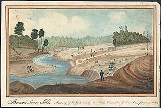
The Cataraqui River forms the lower portion of the Rideau Canal and drains into Lake Ontario at Kingston, Ontario. The name is taken from the original name for Kingston, Ontario; its exact meaning, however, is undetermined. Early maps showed several name variations including the Great Cataraqui River and Grand River Cataraquay. The river was once called Riviere de Frontenac, or Frontenac River. The alternate spelling "Cadaraqui" also appears in some historic texts.

Sydenham, named after Lord Sydenham, is a community in Frontenac County, located in the municipality of South Frontenac. It is situated at the west end of Sydenham Lake and located north of Kingston, Ontario, Canada.

Lanark County is a county located in the Canadian province of Ontario. Its county seat is Perth, which was first settled in 1816 and was known as a social and political capital before being over shadowed by what we now know as Ottawa.

The Gananoque River is a river in Leeds and Grenville United Counties in Eastern Ontario, Canada. The river is in the Atlantic Ocean drainage basin and is a left tributary of the Saint Lawrence River.
Loughborough Lake is a lake in Eastern Ontario, Canada. The lake is mostly in the municipality of South Frontenac, Frontenac County, except for the southern tip which is in and on the northern border of the separated city of Kingston, and is about 20 kilometres (12 mi) north of the town centre of Kingston.

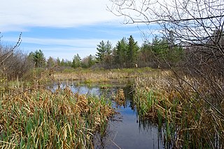
Frontenac Provincial Park is a provincial park located near the town of Sydenham, north of Kingston, Ontario, Canada. This 5,350-hectare park is classified as a natural environment park, and lies on the Frontenac Axis, a topographic extension of the Canadian Shield connecting to the Adirondack Mountains. It features 22 lakes, over 700 species, and extensive areas of mixed forest, wetlands, and granite outcrops.

The K&P Trail is a recreational trail that runs along the old Kingston and Pembroke Railway (K&P) bed in Ontario, Canada.
King's Highway 38, commonly referred to as Highway 38, was a provincially maintained highway in the Canadian province of Ontario. The 66.9-kilometre (41.6 mi) road connected Highway 2 and Highway 401 in Kingston with Highway 7 west of Perth. It was designated in 1934 and remained relatively unchanged throughout its existence, aside from some minor diversions and a rerouting through Kingston as a result of the construction of Highway 401 in the mid-1950s. At the beginning of 1998, the entire highway was transferred to the municipalities of Frontenac County through which it travelled: Kingston, South Frontenac and Central Frontenac. Today the former highway is named Road 38 and Gardiners Road, but is still referred to as Highway 38 by locals.

Murphys Point Provincial Park is a provincial park near Perth, Ontario, Canada. The 1,239-hectare (3,060-acre) park features natural areas prepared for hiking and skiing as well as access for day-use camping and water sports at Big Rideau Lake. Facilities include a park store, visitor centre and several "comfort centres", with flush toilets, showers and laundry facilities for the multi-day camper.

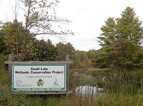
Gould Lake is a lake north of the community of Sydenham in the Township of South Frontenac, Frontenac County, in eastern Ontario, Canada. It is on the Canadian Shield, is part of the Great Lakes Basin, and is part of the headwaters of the Millhaven Creek system. In the 19th century and early-20th century, the area around Gould Lake was noted for its mica mines.
Lake Opinicon is a lake in South Frontenac, Frontenac County and Rideau Lakes, United Counties of Leeds and Grenville in Eastern Ontario, Canada. This shallow lake was formed when Colonel John By built the Rideau Canal. It also is part of the Great Lakes Basin.

Upper Rideau Lake is a freshwater lake located in the municipality of Rideau Lakes, United Counties of Leeds and Grenville in Eastern Ontario, Canada. It is located in the Saint Lawrence River drainage basin and is the lake with the highest altitude within the Rideau Canal system.

The Bay of Quinte Railway was a short-line railway in eastern Ontario, Canada. It was formed as the Napanee, Tamworth and Quebec Railway (NT&QR), chartered in 1878 by Edward Rathbun and Alexander Campbell, with plans to run from Napanee through Renfrew County and on to the Ottawa Valley. Lacking funding from the governments, development never began.

The Cataraqui Trail is a 104-kilometre (65 mi) multi-use linear recreational rail trail in Eastern Ontario, Canada. The route passes by farmland, woods, lakes, and wetlands. The trail begins southwest of Smiths Falls, at a parking lot south of Ontario Highway 15 designated as kilometre zero.
The Cataraqui Region Conservation Authority is one of 36 conservation authorities in the Canadian province of Ontario. It is headquartered in Kingston, Ontario The authority was established by an Order in Council in December 1964 via the Conservation Authorities Act, and is a member authority of Conservation Ontario.
Sand Lake is a lake on the Rideau Canal, located in the Township of Rideau Lakes, Ontario, Canada, in the ward of South Crosby. It is 891 hectares in surface area, with a maximum depth of 14.3 metres (47 ft) and a shore length of 65.5 kilometres (41 mi)
The Carp Hills are a small range of rocky hills between the shallow valleys of the Carp River and Constance Creek, entirely within the West Carleton-March Ward of Canada's capital, Ottawa, Ontario. It runs roughly from Kinburn Side Road southeast to the village of Carp and the South March Highlands at March Road.
Millhaven Creek is a stream in the municipalities of Loyalist, Lennox and Addington County, and South Frontenac, Frontenac County, and the single-tier municipality of Kingston in eastern Ontario, Canada. It is a tributary of Lake Ontario and is under the auspices of the Cataraqui Region Conservation Authority.


