
The Oak Ridges Moraine is an ecologically important geological landform in the Mixedwood Plains of south-central Ontario, Canada. The moraine covers a geographic area of 1,900 square kilometres (730 sq mi) between Caledon and Rice Lake, near Peterborough. One of the most significant landforms in southern Ontario, the moraine gets its name from the rolling hills and river valleys extending 160 km (99 mi) east from the Niagara Escarpment to Rice Lake, formed 12,000 years ago by advancing and retreating glaciers during the last glaciation period. Below the approximately 200 metre thick glacial derived sediments of the moraine lies thick bedrock successions of Precambrian rocks and up to 200 metres of Ordovician aged rock, capped by a regional unconformity of erosion and non-deposition to the Quaternary period. Rivers and lakes scatter the landscape and are important for creating habitat for the rich diversity of species of animals, trees and shrubbery. These are also the supply of fresh water to aquifers in the moraine through complex subterranean connections. Construction development nearby, and with expansion of communities around the moraine in need of potable water, it is a contested site in Ontario, since it stands in the path of major urban development. Conservation of the moraine is thus an important step for keeping aquifers in a safe drinkable condition while also protecting the natural ecosystems surrounding and within the moraine. This region has been subject to multiple decades of scientific research to study the origins of formation, and how early communities used the land. A larger focus currently is how to source potable water without removing the aquifer entirely.

A kettle is a depression or hole in an outwash plain formed by retreating glaciers or draining floodwaters. The kettles are formed as a result of blocks of dead ice left behind by retreating glaciers, which become surrounded by sediment deposited by meltwater streams as there is increased friction. The ice becomes buried in the sediment and when the ice melts, a depression is left called a kettle hole, creating a dimpled appearance on the outwash plain. Lakes often fill these kettles; these are called kettle hole lakes. Another source is the sudden drainage of an ice-dammed lake and when the block melts, the hole it leaves behind is a kettle. As the ice melts, ramparts can form around the edge of the kettle hole. The lakes that fill these holes are seldom more than 10 m (33 ft) deep and eventually fill with sediment. In acidic conditions, a kettle bog may form but in alkaline conditions, it will be kettle peatland.

The Ogoki River is a river in the Thunder Bay and Cochrane Districts of Ontario. It springs from the wilderness just east of Savant Lake, flowing north of Lake Nipigon to Ogoki, where it joins the Albany River which empties into James Bay. The river is 480 kilometres (300 mi) long.

The Amable du Fond River is a river in Nipissing District, in Northern Ontario, Canada.

Lake Nipigon is part of the Great Lakes drainage basin. It is the largest lake entirely within the boundaries of the Canadian province of Ontario.

The Southern Laurentian Channel is an ancient underground river in southern Ontario, Canada. The river predates the recent ice ages. The river valley was filled with glacial debris. Water still flows down this old valley—underground. The source of the aquifer is the Georgian Bay, approximately 200 kilometres (120 mi) away.

Wabakimi Provincial Park is a wilderness park located to the northwest of Lake Nipigon and northwest of Armstrong Station in the province of Ontario, Canada. The park contains a vast and interconnected network of more than 2,000 kilometres of lakes and rivers. The park covers an area of 8,920 square kilometres (3,440 sq mi) and became the second largest park in Ontario and one of the world's largest boreal forest reserves following a major expansion in 1997. A number of local citizen groups and residents, including Bruce Hyer have been instrumental in the creation, expansion, and preservation of this region.
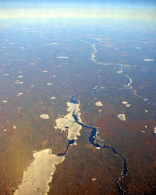
The Albany River is a river in Northern Ontario, Canada, which flows northeast from Lake St. Joseph in Northwestern Ontario and empties into James Bay. It is 982 kilometres (610 mi) long to the head of the Cat River, tying it with the Severn River for the title of longest river entirely in Ontario. Major tributaries include the Kenogami River and Ogoki River.

Awenda Provincial Park is a provincial park in Tiny Township, Simcoe County in Central Ontario, Canada, located on a peninsula jutting into Georgian Bay north of Penetanguishene. The park occupies an area of 2,915 hectares and was established in 1975. It is classified as a Natural Environment Park and therefore all land is protected.
The Waterloo Moraine is a landform and sediment body that was created as a moraine in the Regional Municipality of Waterloo, in Ontario, Canada. It covers a large portion of the cities of Waterloo and Kitchener and the township of Wilmot, and some parts of the townships of Wellesley and North Dumfries. About 90% of the water supply of the Regional Municipality of Waterloo is derived from groundwater of the Waterloo Moraine aquifer system.
The White River is a tributary of Lake Superior in Thunder Bay District, Ontario, Canada. It starts at Negwazu Lake and flows in a predominantly western direction to Lake Superior, passing through the Township of White River.
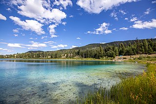
Kentucky Alleyne Provincial Park is a provincial park in British Columbia. The park is located 38 kilometres south of the city of Merritt, and east of the community of Aspen Grove. The park is named for two of its largest lakes, Kentucky Lake and Alleyne Lake. All lakes in the park have a distinctive turquoise colouration.
Spatsizi Plateau Wilderness Provincial Park is located in the northern portion of British Columbia, Canada, approximately 698, 659 hectares and encompasses the Spatsizi River and Gladys Lake Ecological Reserve. The park is a designated protected area that is intended for the conservation and research on caribou, grizzly bears, fish, and other wildlife species populations. Before the provincial park's establishment in 1975, the area was a historical hunting ground for local Indigenous communities like the Tahltan First Nations. It is the second largest provincial park in British Columbia.
The Toronto ravine system is a distinctive feature of the city's geography, consisting of a network of deep ravines, which forms a large urban forest that runs through most of Toronto. The ravine system is the largest in any city in the world, with the Ravine and Natural Feature Protection Bylaw protecting approximately 110 square kilometres (42 sq mi) of public and privately-owned land. The ravine system has been presented as a central characteristic of the city, with the size of the ravine system leading Toronto to be described as "a city within a park".

The Gull River is a river in Thunder Bay District in Northwestern Ontario, Canada. The river is in the Great Lakes Basin and is a tributary of Lake Nipigon.

The Englehart River is a river in Timiskaming District in northeastern Ontario, Canada. It is in the Saint Lawrence River drainage basin and is a right tributary of the Blanche River.
The Makobe River is a river in northeastern Ontario, Canada. It is in the Saint Lawrence River drainage basin, and is a left tributary of the Montreal River.

The Larder River is a river in Timiskaming District, in Northeastern Ontario, Canada. It is in the Saint Lawrence River drainage basin, and flows from its source at Larder Lake in geographic McFadden Township to its mouth as a left tributary of the Blanche River in the municipal township of Evanturel.
The Pipestone River Provincial Park is a provincial park in northern Ontario, Canada, roughly 200 kilometres (120 mi) north of Sioux Lookout. It is a non-contiguous linear waterway park that consists of 3 segments, protecting 316-kilometre-long (196 mi) portions of the Pipestone, Morris, Williams, and Otoskwin Rivers. The segments are separated by an unprotected portion of the Pipestone River at Kingfisher 2A reserve, and between Kecheokagan Lake and the Nord Road. It was established on January 3, 1989, and provides backcountry whitewater canoeing and camping opportunities.

The Oxtongue River is a river in Nipissing and Muskoka Districts, Ontario, Canada. It is a tributary of the Muskoka River via Lake of Bays, flowing in a mostly south-westerly direction through undisturbed mixed forest that is home to many native mammal species.


