
Algonquin Provincial Park is an Ontario provincial park located between Georgian Bay and the Ottawa River, mostly within the Unorganized South Part of Nipissing District. Established in 1893, it is the oldest provincial park in Canada. Additions since its creation have increased the park to its current size of about 7,653 km2 (2,955 sq mi). The park is contiguous with several smaller, administratively separate provincial parks that protect important rivers in the area, resulting in a larger total protected area.

Charleston Lake Provincial Park is located on Charleston Lake near Athens, Ontario, Canada, in the township of Leeds and the Thousand Islands.

Rondeau Provincial Park is the second oldest provincial park in Ontario, Canada, having been established with an order in council on 8 September 1894. The park is located in Southwestern Ontario, on an 8 km long crescentic sand spit extending into Lake Erie. Rondeau is home to the largest area of Carolinian forest in Canada, a long sand beach, a large marsh, approximately half of Rondeau Bay, campgrounds and a cottage community. The name of the park comes from the French words "ronde eau" or "round water" which describes the shape of the harbour sheltered by the peninsula.
The Carolinian forest refers to a life zone in eastern North America characterized primarily by the predominance of deciduous (broad-leaf) forest. The term "Carolinian", which is most commonly used in Canada, refers to the deciduous forests which span across much of the eastern United States from North Carolina northward into southern Ontario, Canada. These deciduous forests in the United States and southern Ontario share many similar characteristics and species hence their association. Today the term is often used to refer to the Canadian portion of the deciduous forest region while the portion in the United States is often referred to as the "Eastern deciduous forest".

Southwestern Ontario is a secondary region of Southern Ontario in the Canadian province of Ontario. It occupies most of the Ontario Peninsula bounded by Lake Huron, including Georgian Bay, to the north and northwest; the St. Clair River, Lake St. Clair, and Detroit River, to the west; and Lake Erie to the south. To the east, on land, Southwestern Ontario is bounded by Central Ontario and the Golden Horseshoe.
MacGregor Point Provincial Park is a park located on Lake Huron, off of Bruce Road 33 near Port Elgin, Ontario, Canada.

Frontenac Provincial Park is a provincial park located near the town of Sydenham, north of Kingston, Ontario, Canada. This 5,350 ha (13,200-acre) park is classified as a natural environment park, and lies on the Frontenac Axis, a topographic extension of the Canadian Shield connecting to the Adirondack Mountains. It features 22 lakes, over 700 species, and extensive areas of mixed forest, wetlands, and granite outcrops.

Sandbanks Provincial Park is a provincial park located on Lake Ontario in Prince Edward County near Picton, Ontario, Canada. The park is considered one of the best sandy beaches in Ontario and contains the largest bay-mouth barrier dune formation in the world. The 1,550.87-hectare (3,832.3-acre) park was established in 1970 and operates year round. Birdwatching, camping, cycling, fishing, and swimming are among the activities available in the park.

Killarney Provincial Park is a provincial park in central Ontario, Canada, located approximately 90 km (56 mi) southwest of downtown Sudbury, Ontario.

A woodlot is a parcel of a woodland or forest capable of small-scale production of forest products as well as recreational uses like bird watching, bushwalking, and wildflower appreciation. The term woodlot is chiefly North American; in Britain, a woodlot would be called a wood, woodland, or copse.

Bonnechere Provincial Park is an Ontario provincial park located on Round Lake in Renfrew County, Ontario, Canada.

The Ojibway Prairie Complex is a 350-hectare complex of parks and nature reserves on the west side of Windsor, Ontario, Canada. It comprises Ojibway Park, Tallgrass Prairie Heritage Park, Black Oak Heritage Park, and the Spring Garden Natural Area, owned and managed by the City of Windsor, as well as Ojibway Prairie Provincial Park, owned and managed by Ontario Parks. Other natural areas are present adjacent to these parks that are not currently protected.

Arrowhead Provincial Park is located north of Huntsville, Ontario, Canada, and is part of the Ontario Parks system. A portion of the shoreline of Glacial Lake Algonquin is visible in the park.
Turkey Point Provincial Park is located in Turkey Point, Ontario, Canada and is part of the Ontario Parks system. It is the only Ontario provincial park to include a golf course. The Normandale Fish Hatchery is in the park, and is accessible via one of the hiking trails.

Ivanhoe Lake Provincial Park is an operating natural environment class park and protected area in the Unorganized North Part of Sudbury District in Northeastern Ontario, Canada. It is in the James Bay drainage basin, encompasses almost all of Ivanhoe Lake on the Ivanhoe River, and is located 8 kilometres (5 mi) southwest of the community of Foleyet on Ontario Highway 101.

The Burnt Lands is an alvar between Almonte and Ottawa near Upper Huntley, Ontario, Canada. It probably obtained its name from one of the forest fires that swept the area during early European settlement.
The Southwest Elgin Forest Complex comprises a 20-kilometer subzone of discontinuous woodlots in southern Ontario within 5 kilometres of the Lake Erie shoreline from John E. Pearce Provincial Park at the eastern end to the Elgin-Kent county border at the western end. Mature forests are often dominated by American beech and sugar maple with a notable presence of species, including sassafras and tulip tree, which are restricted to the Carolinian forest region. Some rare birds are present, most notably hooded warbler in woods and Acadian flycatcher in ravines.
Ferdinand Alphonse Fortunat Larose was a French Canadian agronomist, best known for having created in Ontario one of the largest regeneration forests in the 1920s, named after him.

The forests of Canada are located across much of the country. Approximately half of Canada is covered by forest, totaling around 2.4 million km2. Over 90% of Canada's forests are owned by the public. About half of the forests are allocated for logging.

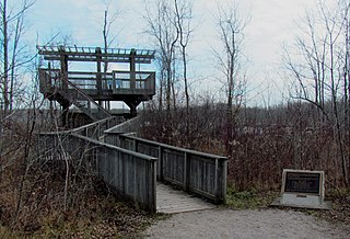
Lynde Shores Conservation Area is a protected area located in Whitby, Ontario, Canada. Located on the northern shore of Lake Ontario, the conservation area composes the mouth of Lynde Creek and its surrounding marshlands, including Cranberry Marsh. The area is operated by the Central Lake Ontario Conservation Authority.


