Long Point is a sand spit and medium-sized hamlet on the north shore of Lake Erie, part of Norfolk County in the province of Ontario, Canada.

Pacific Rim National Park Reserve is a 511 km2 (197 sq mi) national park located in British Columbia, Canada, which comprises three separate regions: Long Beach, the Broken Group Islands, and the West Coast Trail. Its the Pacific Coast Mountains, are characterized by rugged coasts and temperate rainforests.

Thunder Bay District is a district and census division in Northwestern Ontario in the Canadian province of Ontario. The district seat is Thunder Bay.

Lake Superior Provincial Park is one of the largest provincial parks in Ontario, covering about 1,550 square kilometres (600 sq mi) along the northeastern shores of Lake Superior between Sault Ste. Marie and Wawa in Algoma District in Northeastern Ontario, Canada. Ontario Highway 17 now runs through the park. When the park was established by Ontario in 1944, there was no road access.

Rondeau Provincial Park is the second oldest provincial park in Ontario, Canada, having been established with an order in council on 8 September 1894. The park is located in Southwestern Ontario, on an 8 km long crescentic sand spit extending into Lake Erie. Rondeau is home to the largest area of Carolinian forest in Canada, a long sand beach, a large marsh, approximately half of Rondeau Bay, campgrounds and a cottage community. The name of the park comes from the French words "ronde eau" or "round water" which describes the shape of the harbour sheltered by the peninsula.

Lake Nipigon is part of the Great Lake drainage basin. It is the largest lake entirely within the boundaries of the Canadian province of Ontario.
The Black Sturgeon River is a river in Thunder Bay District, Northwestern Ontario, Canada, located west of the Nipigon River, that flows to Lake Superior.
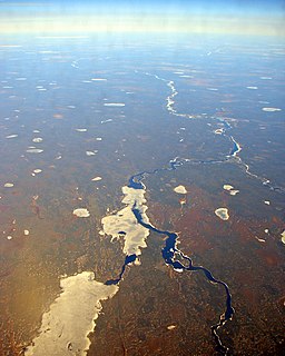
The Albany River is a river in Northern Ontario, Canada, which flows northeast from Lake St. Joseph in Northwestern Ontario and empties into James Bay. It is 982 kilometres (610 mi) long to the head of the Cat River, tying it with the Severn River for the title of longest river in Ontario. Major tributaries include the Kenogami River and Ogoki River.
Ipperwash Provincial Park is a former provincial park on the shores of southern Lake Huron in Lambton County, Ontario, Canada.

Killarney Provincial Park is a provincial park in central Ontario, Canada.

Whiteshell Provincial Park is a provincial park in southeast Manitoba, approximately 120 kilometres (75 mi) east of the city of Winnipeg. The park is considered to be a Class II protected area under the IUCN protected area management categories. It is 275,210 hectares in size.
Long Point Provincial Park is a provincial park on the northwest shore of Lake Erie near Port Rowan, Ontario, Canada. The park is part of a sandy spit of land called Long Point that juts out into the lake. It covers part of the area of Long Point Biosphere Reserve, which was designated a UNESCO Biosphere Reserve because of its biological significance.

Serpent Mounds Park is a former historical and recreational park located in Keene, Ontario, Canada. Serpent Mounds operated as a provincial park, established in 1955 through a lease with the Hiawatha First Nation, a historic Mississaugas people. During this time, in 1982, the mounds were designated a National Historic Site, comprising six sites, including on east Sugar Island. From 1995 to 2009, the Hiawatha First Nation operated the park privately, offering camping facilities, beach access on Rice Lake, a cultural centre, and interpretive walks among the historic serpent and nearby mounds. The park has been closed since 2009.
Lake Superior National Marine Conservation Area is a National Marine Conservation Area (NMCA) on the north shore of Lake Superior in Ontario, and is a unit of the national park system. Established on September 1, 2015, it is the largest freshwater marine protected area in the world.

Blackstrap Provincial Park is a provincial park in the Canadian province of Saskatchewan in the RM of Dundurn. Prior to the park's establishment in 1986, it was a provincial recreation site. The park runs along the eastern shore of Blackstrap Lake and consists of a conservation area, campground, beaches, Mount Blackstrap, cross country ski trails, biking and hiking trails, and several picnicking areas. It is located at LSD 32-3 W3, east of Dundurn and accessed via Highway 211. Mount Blackstrap is a man-made mountain built as a skill hill for the 1971 Canada Winter Games. It continued to operated as a ski hill until 2007.
The Bingwi Neyaashi Anishinaabek is an Ojibwe First Nation Band government in Northwestern Ontario, Canada.
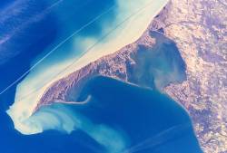
Gravel River Provincial Park is a nature reserve in the Thunder Bay District of Ontario, Canada. It protects an unusual birds-foot delta at the mouth of the Gravel River.
Candle Lake Provincial Park is a provincial park in the central region of the Canadian province of Saskatchewan. Prior to the park's establishment in 1986, it was a provincial recreation site. Located in the Rural Municipality of Paddockwood No. 520, Candle Lake Provincial Park surrounds most of Candle and Torch Lakes in the boreal forest ecozone of Canada. The park has a variety of activities including camping, boating, fishing, swimming, mini golfing, hiking, and golfing. Around the lake there are also boat launches and several marinas. Natural attractions include a purple sand beach, sand dunes, mature forests, crystal clear lake water, and several natural sand beaches.

The Kopka River is a river in northwestern Ontario, Canada. It forms at the height-of-land west of Lake Nipigon, flowing through rugged wilderness of Ontario's northern boreal forest, and drains into Wabinosh Lake.

