Victoria University may refer to:

Scarborough is a district of Toronto, Ontario, Canada. It is situated atop the Scarborough Bluffs in the eastern part of the city. Its borders are Victoria Park Avenue to the west, Steeles Avenue and the city of Markham to the north, Rouge River and the city of Pickering to the east, and Lake Ontario to the south. Scarborough was named after the English town of Scarborough, North Yorkshire, inspired by its cliffs.

Events from the year 1854 in Canada.
The Toronto and Region Conservation Authority (TRCA) is a conservation authority in southern Ontario, Canada. It owns about 16,000 hectares of land in the Toronto region, and it employs more than 400 full-time employees and coordinates more than 3,000 volunteers each year. TRCA's area of jurisdiction is watershed-based and includes 3,467 square kilometres (1,339 sq mi) – 2,506 on land and 961 water-based in Lake Ontario. This area comprises nine watersheds from west to east – Etobicoke Creek, Mimico Creek, Humber River, Don River, Highland Creek, Petticoat Creek, Rouge River, Duffins Creek and Carruthers Creek.

Noah Nicholas Reid is a Canadian-American actor and musician, best known for his work on the television series Franklin and Schitt's Creek. In 2016, he received a Canadian Screen Award nomination for Best Original Song for his work in the feature film People Hold On. In 2019, he received a Canadian Screen Award for Best Supporting Actor in a Comedy for his work on Schitt's Creek.
O'Connor–Parkview is a neighbourhood in the East York area of Toronto, Ontario, Canada. While the name is taken from the definition used by the city of Toronto, local residents are more familiar with the niche areas that define the larger neighbourhood. It is a very diverse neighbourhood that includes English-speakers and Greeks in the west, to the Tamil speakers in the east and Bengali people in the south. It includes low-income highrises, to huge property lots. The smaller areas included inside the neighbourhood are Topham Park, Woodbine Gardens and Parkview Hills.

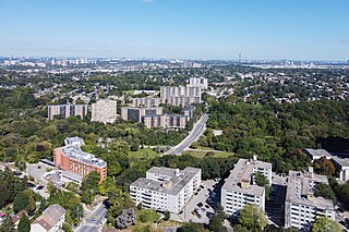
Old East York is a district of the city of Toronto, Ontario, Canada. It consists of the southern, urban, portion of the former borough of East York. Old East York is continuous and functionally integrated with the old City of Toronto, bounded by the old municipal boundary between East York and Old Toronto on the south, by the Don River Valley on the west and northwest, by Taylor-Massey Creek on the north, and Victoria Park Avenue in the east.

Tam O'Shanter-Sullivan is a neighbourhood in the east end of the city of Toronto, Ontario, Canada, in the district of Scarborough. The neighbourhood is bordered by Huntingwood Drive to the North, Kennedy Road to the East, Highway 401 to the South and Victoria Park to the West. The neighbourhood, which includes the Tam O'Shanter and Sullivan communities, takes its name from Tam O’Shanter Golf Course and O'Sullivan's Corners.

Clairlea is a safe, quiet, middle to upper-middle income neighbourhood in Toronto, Ontario, Canada that features well treed streets and detached homes with large backyards. The neighbourhood is located in east Toronto just east of Victoria Park Avenue.

Felix Johan Douma was a Canadian scholar, writer, teacher, cellist, and translator who once served as Canada's Third Secretary and Vice-Consul to the Dominican Republic.
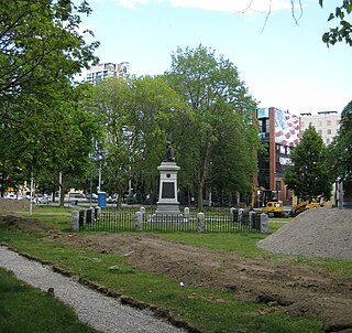
Victoria Memorial Square is a park and former cemetery in Toronto, Ontario, Canada. Established in 1793 as the burial place for those affiliated with the nearby Toronto Garrison. It was the first cemetery to be used by European settlers in what would become the city of Toronto. Originally known as St. John's Square, the park today is part of Fort York National Historic Site, and the site of a monument to the War of 1812 sculpted by Walter Seymour Allward and completed in 1902.
The Academy of Canadian Cinema and Television presents an annual award for Best Comedy Series.
Jackson Creek may refer to:
Petticoat Creek is a stream in the cities of Pickering, Toronto and Markham in the Greater Toronto Area of Ontario, Canada. The creek is in the Great Lakes Basin, is a tributary of Lake Ontario, and falls under the auspices of the Toronto and Region Conservation Authority. Its watershed covers 26.77 square kilometres (10.34 sq mi), and the cumulative length of all its branches is 49 kilometres (30 mi). Land use in the watershed consists of 52% agricultural, 27% protected greenspace and 21% urban.

Schitt's Creek is a Canadian television sitcom created by Dan Levy and his father, Eugene Levy, that aired on CBC Television from 2015 to 2020. It consists of 80 episodes spread over six seasons. Produced by Not a Real Company Productions and the Canadian Broadcasting Corporation, it follows the trials and tribulations of the formerly wealthy Rose family. After their business manager embezzles the family business, Rose Video, the family loses its fortune and relocates to Schitt's Creek, a town they once purchased as a joke. Now living in a motel, Johnny and Moira — along with their adult offspring, David and Alexis — must adjust to life without wealth.
Petticoat Creek is a small coastal locality in the Shire of Colac Otway, Victoria, Australia. In the 2011 census, the population of Petticoat Creek was too low to report separately; however in November 2014 the Victorian Electoral Commission recorded two enrolled voters in Petticoat Creek, living in two properties.
The 9thannualCanadian Screen Awards were held in the week of May 17 to 20, 2021, to honour achievements in Canadian film, television, and digital media production in 2020.

Black Bodies is a 2020 Canadian short film, directed by Kelly Fyffe-Marshall, and produced by Tamar Bird and Sasha Leigh Henry. Inspired by a real-life incident when Fyffe-Marshall, Komi Olaf and Donisha Prendergast were travelling in California, and a woman in the neighbourhood called the police on them because she wrongly believed they were burglarizing their Airbnb rental, the film features Olaf and Prendergast performing spoken word pieces about the trauma of being victimized by anti-Black racism.
The Canadian Screen Award for Best Reality/Competition Series is an annual Canadian television award, presented by the Academy of Canadian Cinema and Television to the best Canadian reality television series. Previously presented as part of the Gemini Awards, since 2013 it has been presented as part of the Canadian Screen Awards.