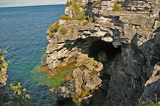
Bruce Peninsula National Park is a national park on the Bruce Peninsula in Ontario, Canada. Located on a part of the Niagara Escarpment, the park comprises 156 square kilometres and is one of the largest protected areas in southern Ontario, forming the core of UNESCO's Niagara Escarpment World Biosphere Reserve. It was established in 1987 to protect the rock formations and shoreline of the Niagara Escarpment. The park offers opportunities for many outdoor activities, including hiking, camping, and bird watching. The park has trails ranging in difficulty from easy to expert, and connects to the Bruce Trail. Bruce Peninsula National Park is known for its crystal clear blue waters, cobblestone beaches, rocky cliffs and karst formations.

The Bruce Trail is a hiking trail in southern Ontario, Canada, from the Niagara River to the tip of Tobermory, Ontario. The main trail is more than 890 km (550 mi) long and there are over 400 km (250 mi) of associated side trails. The trail mostly follows the edge of the Niagara Escarpment, one of the nineteen UNESCO World Biosphere Reserves in Canada. The land the trail traverses is owned by the Government of Ontario, local municipalities, local conservation authorities, private landowners, and the Bruce Trail Conservancy (BTC). The Bruce Trail is the oldest and longest marked hiking trail in Canada. Its name is linked to the Bruce Peninsula and Bruce County, through which the trail runs. The trail is named after the county, which was named after James Bruce, 8th Earl of Elgin who was Governor General of the Province of Canada from 1847 to 1854.

Burlington is a city in the Regional Municipality of Halton at the west end of Lake Ontario in Ontario, Canada. Located approximately halfway between Toronto and Niagara Falls, it is part of the Greater Toronto Area and Hamilton metropolitan census area.

Milton is a town in Southern Ontario, Canada, and part of the Halton Region in the Greater Toronto Area. Between 2001 and 2011, Milton was the fastest growing municipality in Canada, with a 71.4% increase in population from 2001 to 2006 and another 56.5% increase from 2006 to 2011. In 2016, Milton's census population was 110,128 with an estimated growth to 228,000 by 2031. It remained the fastest growing community in Ontario but was deemed to be the sixth fastest growing in Canada at that time.

Halton Hills is a town in the Regional Municipality of Halton, located in the northwestern end of the Greater Toronto Area, Ontario, Canada with a population of 61,161 (2016).
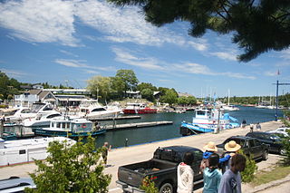
Tobermory is a small community located at the northern tip of the Bruce Peninsula, in the traditional territory of the Saugeen Ojibway Nation. Until European colonization in the mid-19th century, the Bruce Peninsula was home to the Saugeen Ojibway nations, with their earliest ancestors reaching the area as early as 7,500 years ago. It is part of the municipality of Northern Bruce Peninsula. It is 300 kilometres northwest of Toronto. The closest city to Tobermory is Owen Sound, 100 kilometres south of Tobermory and connected by Highway 6.
The Regional Municipality of Halton, or Halton Region, is a regional municipality in Ontario, Canada, located in the Golden Horseshoe of Southern Ontario. It comprises the city of Burlington and the towns of Oakville, Milton, and Halton Hills. Policing in the Region is provided by the Halton Regional Police Service. The regional council's headquarters are located in Oakville. Burlington, Oakville, and Milton are largely urban and suburban, while Halton Hills is more rural.

The Bruce Peninsula is a peninsula in Ontario, Canada, that divides Georgian Bay of Lake Huron from the lake's main basin. The peninsula extends roughly northwestwards from the rest of Southwestern Ontario, pointing towards Manitoulin Island, with which it forms the widest strait joining Georgian Bay to the rest of Lake Huron. The Bruce Peninsula contains part of the geological formation known as the Niagara Escarpment.
Royal Botanical Gardens (RBG) is headquartered in Burlington owning extensive environmental protection areas, historic sites and culturally relevant gardens in Hamilton, Ontario, Canada. It is one of the major tourist attractions between Niagara Falls and Toronto, as well as a significant local and regional horticultural, education, conservation, and scientific resource. The mandate is derived by a Provincial Act of 1941 centred on human interaction with the natural world and protection of environmentally significant lands that form the western tip of Lake Ontario. Royal Botanical Gardens spans an area of about 10 km by 4 km, dominated by two coastal wetlands, and glacial-carved landscapes that extend from the lake up to the Niagara Escarpment plateau. The various gardens and natural areas are accessed through nine public entrance locations. It is one of several Prescribed Public Bodies listed under the Ontario Heritage Act.

Sixteen Mile Creek is a river in Halton Region in the Greater Toronto Area of Ontario, Canada. It is in the Great Lakes Basin, and flows from the Niagara Escarpment through the towns of Milton and Oakville to Lake Ontario.

Crawford Lake Conservation Area is a conservation area owned and operated by Conservation Halton near the community of Campbellville in Milton, Halton, Ontario, Canada. It is categorized as a regional environmentally sensitive area, an Ontario Area of Natural and Scientific Interest, and part of the Niagara Escarpment world biosphere reserve. The conservation area contains Crawford Lake, a reconstructed Iroquoian village, and several hiking trails.
Conservation Halton, also known as the Halton Region Conservation Authority, is a conservation authority established under the Conservation Authorities Act of Ontario. It forms a partnership with the Province of Ontario, the Ministry of Natural Resources and the regional municipalities of Halton, Peel, The County of Wellington, and surrounding municipalities.
The Mount Nemo Conservation Area in Burlington, Ontario is a conservation area owned and operated by Conservation Halton. It is popular with rock climbers in the Greater Toronto Area and the Golden Horseshoe, along with nearby Rattlesnake Point Conservation Area. Its five kilometers of hiking trails connect with the Bruce Trail.

Kelso Conservation Area is located near Milton, Ontario on the Niagara Escarpment and is owned and operated by Conservation Halton. This park has an area of 3.97 square kilometres and contains Lake Kelso which was built for flood control of Sixteen Mile Creek and has a sandy beach for swimmers in the summer with a food concession and board walk along the lake to the Boat Rental shop which offers the rentals of canoes, kayaks, paddle boards, paddle boats and is also open to any non-motorized watercraft. The Park also offers 20 campsites, 18 reserve-able picnic sites, and two camping/picnic mixed sites. Glen Eden Ski & Snowboard Centre is located in the park and offers downhill skiing, snowboarding and tubing during the winter months. In addition, the Halton Region Museum is also located on the Kelso grounds. The park also features marked mountain biking and hiking trails.

Hilton Falls Conservation Area located in Campbellville, Ontario on the Niagara Escarpment is a conservation area known for its ten-metre waterfall, hiking trails and small glacial pothole. It constitutes 645 hectares and offers mountain biking as well as cross-country skiing. It is owned and operated by Conservation Halton. The Bruce Trail runs through the area.
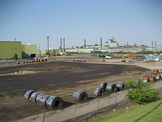
Kenilworth Avenue is a Lower City arterial road in Hamilton, Ontario, Canada. It starts off at the Kenilworth Traffic Circle and Kenilworth Access, a mountain-access road at the base of the Niagara Escarpment (mountain) and is a two-way street throughout stretching northward through the city's North End industrial neighbourhood where it then flows underneath the Burlington Street bridge and right into Dofasco's Industrial Park.

Crawford Lake is a lake near the community of Campbellville, in the town of Milton, Regional Municipality of Halton, Ontario, Canada. It is located within Crawford Lake Conservation Area, a Regionally Environmentally Sensitive Area, an Ontario Area of Natural and Scientific Interest, and part of the Niagara Escarpment World Biosphere Reserve.

Campbellville is a compact rural community in the geographic township of Nassagaweya in the Town of Milton, Regional Municipality of Halton, Ontario, Canada. It is on the Niagara Escarpment and is a tourist destination for residents of the Greater Toronto Area.
The Ontario Alliance of Climbers is an independent, provincial, volunteer, non-profit organization that works to keep climbing and bouldering areas open in Ontario, Canada. The organization's stated purpose is to help conserve access to climbing by advocating protection for the climbing environment, by resolving access issues as they arise, and by proactively engaging with and educating the climbing community.


