
Point Pelee National Park is a national park in Essex County in southwestern Ontario, Canada where it extends into Lake Erie. The word pelée is French for 'bald'. Point Pelee consists of a peninsula of land, mainly of marsh and woodland habitats, that tapers to a sharp point as it extends into Lake Erie. Middle Island, also part of Point Pelee National Park, was acquired in 2000 and is just north of the Canada–United States border in Lake Erie. Point Pelee is the southernmost point of mainland Canada, and is located on a foundation of glacial sand, silt and gravel that bites into Lake Erie. This spit of land is slightly more than seven kilometres long by 4.5 kilometres (2.8 mi) wide at its northern base. Established in 1918, Point Pelee was the first national park in Canada to be established for conservation. It was designated as a Ramsar site on 27 May 1987.

The Thousand Islands – Frontenac Arch region or the Frontenac Axis is an exposed strip of Precambrian rock in Canada and the United States that links the Canadian Shield from Algonquin Park with the Adirondack Mountain region in New York, an extension of the Laurentian mountains of Québec. The Algonquin to Adirondacks region, which includes the Frontenac Axis or Arch, is a critical linkage for biodiversity and resilience, and one with important conservation potential. The axis separates the St. Lawrence Lowlands and the Great Lakes Lowlands. It has many distinctive plant and animal species. It is one of four ecoregions of the Mixedwood Plains.
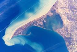
Long Point is a sand spit and medium-sized hamlet on the north shore of Lake Erie, part of Norfolk County in the province of Ontario, Canada.

Algonquin Provincial Park is an Ontario provincial park located between Georgian Bay and the Ottawa River, mostly within the Unorganized South Part of Nipissing District. Established in 1893, it is the oldest provincial park in Canada. Additions since its creation have increased the park to its current size of about 7,653 km2 (2,955 sq mi). The park is contiguous with several smaller, administratively separate provincial parks that protect important rivers in the area, resulting in a larger total protected area.

Killbear Provincial Park is a provincial park located on Georgian Bay in the Parry Sound District of Ontario, near the town of Nobel. Killbear combines sandy beaches typical of the Great Lakes with the rock ridges and pines of the Canadian Shield. The park boundaries lie within the Georgian Bay Littoral UNESCO Biosphere Reserve.
The Royal Botanical Gardens (RBG) is a heritage-listed botanical garden located in the cities of Burlington and Hamilton in Ontario, Canada. It covers extensive environmentally protected areas, historic sites, and culturally relevant gardens from Burlington to Hamilton. It is one of the major tourist attractions between Niagara Falls and Toronto, as well as being a significant local and regional horticultural, education, conservation, and scientific resource.

Awenda Provincial Park is a provincial park in Tiny Township, Simcoe County in Central Ontario, Canada, located on a peninsula jutting into Georgian Bay north of Penetanguishene. The park occupies an area of 2,915 hectares and was established in 1975. It is classified as a Natural Environment Park and therefore all land is protected.

Turtle Mountain Provincial Park is a provincial park located in the southwestern portion of the Canadian province of Manitoba. Within it are the Adam Lake and Max Lake campgrounds. The park is known for its bike trails, fishing, back country cabins and canoe routes. The park is very popular with families and outdoor enthusiasts.
Riding Mountain National Park is a national park in Manitoba, Canada. The park is located within Treaty 2 Territory and sits atop the Manitoba Escarpment. Consisting of a protected area of 2,969 km2 (1,146 sq mi), the forested parkland stands in sharp contrast to the surrounding prairie farmland. It was designated a national park because it protects three different ecosystems that converge in the area; grasslands, upland boreal and eastern deciduous forests. It is most easily reached by Highway 10 which passes through the park. The south entrance is at the townsite of Wasagaming, which is the only commercial centre within the park boundaries.
Cootes Paradise is a property with many boundaries, but is primarily a property of the Royal Botanical Gardens at the western end of Lake Ontario, but is also remnant of the larger 3700 acre Dundas Marsh Crown Game Preserve established by the province of Ontario in 1927., dominated by a 4.5 km long rivermouth wetland, representing the lake's western terminus. It is found on the west side of Hamilton Harbour and is located in the municipality of Hamilton, Ontario, Canada. Cootes Paradise Environmentally Sensitive Area is larger "core area" within the City of Hamilton's Natural Heritage System and has a very similar boundary to the original Dundas Crown Game Preserve.
MacGregor Point Provincial Park is a park located on Lake Huron, off of Bruce Road 33 near Port Elgin, Ontario, Canada.

Protected areas of Canada consist of approximately 12.1 percent of the nation's landmass and freshwater are considered conservation areas, including 11.4 percent designated as protected areas. Approximately 13.8 percent of Canada's territorial waters are conserved, including 8.9 percent designated as protected areas. Terrestrial areas conserved have increased by 65 percent in the 21st century, while marine areas conserved have increased by more than 3,800 percent.

Killarney Provincial Park is a provincial park in central Ontario, Canada.

Golden Ears Provincial Park is a 555.9 square kilometres (214.6 sq mi) provincial park in British Columbia, Canada. It is named after the prominent twin peaks, which are commonly referred to as Golden Ears. The park was originally part of Garibaldi Provincial Park but was split off as a separate park in 1967. The area was logged extensively in the 1920s by the Lougheed and Abernathy Logging Company. Many recreational attractions are found within the park. Golden Ears Provincial Park is a protected area that contains many endangered species of flora and fauna.

Last Mountain Lake, also known as Long Lake, is a prairie lake formed from glaciation 11,000 years ago. It is located in south central Saskatchewan, Canada, about 40 kilometres (25 mi) north-west of the city of Regina. It flows into the Qu'Appelle River via Last Mountain Creek, which flows past Craven. It is approximately 93 km (58 mi) long, and 3 km (1.9 mi) across at its widest point. It is the largest naturally occurring body of water in southern Saskatchewan. Only Lake Diefenbaker, which is man-made, is larger. The lake is a popular resort area for residents of south-eastern Saskatchewan.
Beausoleil Island; Île Beausoleil; is an 8-kilometre (5.0 mi) long island in the municipality of Georgian Bay, District Municipality of Muskoka in Central Ontario, Canada. The island is named after Louis Beausoleil, an American born settler whose 1819 homestead stood at the island's southern tip. The name of the island in the Huron-Wendat language is Skiondechiara which means "The land to appear floating afar". The name of the island in the Anishinaabemowin language is variously Pamedenagog, Baamidoonegog or Epenmindaagoog meaning “rocky place floating about the mouth of a river”. Located in the Thirty Thousand Islands in Georgian Bay on Lake Huron, it is the largest island in Georgian Bay Islands National Park and is the only place in the park where camping is allowed. Beausoleil Island is also part of the Georgian Bay Littoral UNESCO Biosphere reserve.

The Long Point Biosphere Reserve is located in southern Canada on the shores of Lake Erie in Norfolk County. The area encompasses a rich mosaic of ecological systems associated with erosion deposit sand spit formations around the Laurentian Great Lakes, as well as some of the largest remaining forest tracts in "Carolinian Canada". The variety of habitats supports a rich flora and fauna, including a waterfowl staging area and a migration stopover area for land birds of continental importance. Long Point Biosphere Reserve has been recognized as a Ramsar site and as a globally significant Important Bird Area by Bird Life International. Established in 1960, the bird observatory is the oldest, continuously operated, in North America.

Mont-Tremblant National Park is a provincial park in Canada located north of the town of Mont-Tremblant, and the village of Saint-Donat and Saint-Côme, in the administrative regions of Laurentides and Lanaudière, in Quebec, in Canada.

The Beaver Hills, also known as the Beaver Hills Moraine and the Cooking Lake Moraine, are a rolling upland region in Central Alberta, just to the east of Edmonton, the provincial capital. It consists of 1,572 square kilometres (607 sq mi) of "knob and kettle" terrain, containing many glacial moraines and depressions filled with small lakes. The landform lies partly within five different counties, Strathcona, Leduc, Beaver, Lamont and Camrose. The area is relatively undeveloped compared to the surrounding region, and is protected in part by Elk Island National Park, the Cooking Lake–Blackfoot Provincial Recreation Area, the Ministik Lake Game Bird Sanctuary, Miquelon Lake Provincial Park and a number of smaller provincial natural areas. Since 2016 Beaver Hills has been a UNESCO-designated biosphere reserve.

The Long Point National Wildlife Area is a Protected area of Canada and one of ten National Wildlife Areas in Ontario. It is the core area of the Long Point Biosphere Reserve, created in 1986, and has been recognized as a Ramsar site since 1982.


