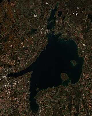
Lake Simcoe is a lake in southern Ontario, Canada, the fourth-largest lake wholly in the province, after Lake Nipigon, Lac Seul, and Lake Nipissing. At the time of the first European contact in the 17th century, the lake was called Ouentironk by the native Wendat/Ouendat (Huron) people. It was also known as Lake Taronto until it was renamed by John Graves Simcoe, the first Lieutenant-Governor of Upper Canada, in memory of his father, Captain John Simcoe of the Royal Navy. In Anishinaabemowin, the historical language of the First Nations living around this lake, namely Anishinaabek of Rama and Georgina Island First Nations, the lake is called Zhooniyaang-zaaga'igan, meaning "Silver Lake".

The Mohawk River is a 149-mile-long (240 km) river in the U.S. state of New York. It is the largest tributary of the Hudson River. The Mohawk flows into the Hudson in Cohoes, New York, a few miles north of the state capital of Albany. The river is named for the Mohawk Nation of the Iroquois Confederacy. A major waterway, in the early 19th century, the river's east-west valley provided the setting and water for development of the Erie Canal, as a key to developing New York. The largest tributary, the Schoharie Creek, accounts for over one quarter (26.83%) of the Mohawk River's watershed. Another main tributary is the West Canada Creek, which makes up for 16.33% of the Mohawk's watershed.

The Don River is a watercourse in southern Ontario that empties into Lake Ontario, at Toronto Harbour. Its mouth was just east of the street grid of the town of York, Upper Canada, the municipality that evolved into Toronto, Ontario. The Don is one of the major watercourses draining Toronto that have headwaters in the Oak Ridges Moraine.

The Humber River is a river in Southern Ontario, Canada. It is in the Great Lakes Basin, is a tributary of Lake Ontario and is one of two major rivers on either side of the city of Toronto, the other being the Don River to the east. It was designated a Canadian Heritage River on September 24, 1999.

Norfolk County is a rural single-tier municipality on the north shore of Lake Erie in Southwestern Ontario, Canada with a 2023 population of 73,015. Despite its name, it is no longer a county by definition, as all municipal services are handled by a single level of government. The largest community in Norfolk County is Simcoe, whose 2021 population was 16,121. The other population centres are Port Dover, Delhi, Waterford and Port Rowan, and there are many smaller communities. For several years in the late 20th century, the county was merged with Haldimand County but the merged entity was dissolved in 2000.

The Grand River, formerly known as the River Ouse, is a large river in Ontario, Canada. It lies along the western fringe of the Greater Golden Horseshoe region of Ontario which overlaps the eastern portion of southwestern Ontario, sometimes referred to as Midwestern Ontario, along the length of this river. From its source near Wareham, Ontario, it flows south through Grand Valley, Fergus, Elora, Waterloo, Kitchener, Cambridge, Paris, Brantford, Ohsweken, Six Nations of the Grand River, Caledonia, and Cayuga before emptying into the north shore of Lake Erie south of Dunnville at Port Maitland. One of the scenic and spectacular features of the river is the falls and Gorge at Elora.
Kettle Creek is a creek in Elgin County in southwestern Ontario, Canada that empties into Lake Erie at Port Stanley. It drains an area of 520 square kilometres (200 sq mi). Dodd Creek is the major tributary.

Port Dover is an unincorporated community and former town located in Norfolk County, Ontario, Canada, on the north shore of Lake Erie. It is the site of the recurring Friday the 13th motorcycle rally. Prior to the War of 1812, this community was known as Dover Mills.
Stoney Creek may refer to:

Delhi refers to both a former township and unincorporated community located off of the junction of Ontario Highways 59 and 3. Delhi is known as the "Heart of Tobacco Country." Prior to 1880, this community was known for its lumber industry. One of the Communities in Norfolk County, Ontario, Delhi, had a population of 4,240 at the time of the 2016 Census.
Port Rowan is a town in Norfolk County, Ontario, Canada. It is located on Lake Erie, adjacent to Long Point. The lakeside community has a population of 1,357 people as of 2021 and sports a number of traditional small businesses which have been operating in the town for decades.

Walsh is a medium-sized hamlet in Norfolk County, Ontario, Canada.

The Lake Simcoe Region Conservation Authority is a conservation authority established in 1951, and is among the oldest in the Canadian province of Ontario.

Lake Erie Basin consists of Lake Erie and surrounding watersheds, which are typically named after the river, creek, or stream that provides drainage into the lake. The watersheds are located in the states of Indiana, Michigan, New York, Ohio, and Pennsylvania in the United States, and in the province of Ontario in Canada. The basin is part of the Great Lakes Basin and Saint Lawrence River Watershed, which feeds into the Atlantic Ocean. 80% of the lake's water flows in from the Detroit River, with only 9% coming from all of the remaining watersheds combined. A littoral zone serves as the interface between land and lake, being that portion of the basin where the lake is less than 15 feet (4.6 m) in depth.
Twelve Mile Creek is a waterway located on the Niagara Peninsula in the Regional Municipality of Niagara in Southern Ontario, Canada. Its headwaters are located in the town of Pelham, encompassing some of the most unspoiled and natural areas of Niagara area. The creek's lower reaches flow through urban areas of Thorold and St. Catharines and has been heavily altered by human activity for almost two centuries. The creek was first known as "Ashquasing" by the Mississaugas Indigenous people, the name meaning "that which lies at the end" in the Anishinaabe language.

Norfolk County in the Canadian province of Ontario consists of a long list of communities. Its four designated population centres are Simcoe, Port Dover, Delhi, and Waterford.
Nanticoke Creek is a watercourse in Haldimand County, Ontario. It is approximately 15 kilometres (9.3 mi) long, emptying into Lake Erie approximately 15 km west of the mouth of the Grand River. The creek drains approximately 180 square kilometres (69 sq mi).
Big Creek is a watercourse in Norfolk County, Ontario. It is approximately 60 kilometres (37 mi) long. It empties into Lake Erie, at Port Rowan, at Long Point. Its watershed covers 730 square kilometres (280 sq mi), alternately 750 square kilometres (290 sq mi).
Venison Creek is the largest tributary to Big Creek, in the Long Point Region Conservation Area, on the north shore of Lake Erie, in Ontario, Canada.
The Long Point Region Conservation Area is an agency of the province of Ontario, Canada, formed to preserve the volume of flow, and purity, of the watercourses that flow into Lake Erie, near Long Point.
