
Fort Henry National Historic Site is located in Kingston, Ontario, Canada on Point Henry, a strategic, elevated point near the mouth of the Cataraqui River where it flows into the St. Lawrence River at the east end of Lake Ontario. The fort and the point on which the fort was built were named after Henry Hamilton, former Lieutenant-Governor of the Province of Quebec.
Fort Ontario is an American historic bastion fort situated by the City of Oswego in Oswego County, New York. It is owned by the state of New York and operated as a museum known as Fort Ontario State Historic Site.
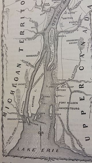
Fort Amherstburg was built by the Royal Canadian Volunteers at the mouth of the Detroit River to replace Fort Detroit, which Britain was required to cede to the United States of America in 1796 as a result of the Jay Treaty.

The siege of Detroit, also known as the surrender of Detroit or the Battle of Fort Detroit, was an early engagement in the War of 1812. A British force under Major General Isaac Brock with Native American allies under Shawnee leader Tecumseh used bluff and deception to intimidate U.S. Brigadier General William Hull into surrendering the fort and town of Detroit, Michigan, along with his dispirited army which actually outnumbered the victorious British and Indians.

The Battle of Craney Island was a victory for the United States during the War of 1812. The battle saved the city of Norfolk, and the adjacent city of Portsmouth, from British invasion. Especially important to Virginia and northeastern North Carolina, the region was a major hub for American commerce.

Fort Wayne was a series of three successive military log stockades existing between 1794 and 1819 in the Miami Indian village of Kekionga, on the portage between the St. Mary's and St. Joseph Rivers in northeastern Indiana, in what is now the city of Fort Wayne. The fort succeeded the original Fort Miami, which originated as a French trading outpost around 1706.

Fort Presque Isle was a fort built by French soldiers in summer 1753 along Presque Isle Bay at present-day Erie, Pennsylvania, to protect the northern terminus of the Venango Path. It was the first of the French posts built in the Ohio Country, and was part of a line that included Fort Le Boeuf, Fort Machault, and Fort Duquesne.

The Backus Heritage Conservation Area is located in Norfolk County, Ontario, Canada.
Nancy was a schooner, built in Detroit, Michigan and launched in 1789. She served for several years in the fur trade on the Great Lakes, but is best known for playing a part in the Anglo-American War of 1812. She served for several years as a vital supply ship for the Provincial Marine. The Royal Navy took over the Provincial Marine in 1814 and so acquired Nancy. After HMS Nancy was blocked in by an American fleet near the mouth of the Nottawasaga River, her crew set her on fire on 14 August 1814 to prevent the capture of the ship and the cargo she carried. Forgotten for many years, the wreck was re-discovered in July 1927 and raised to form the centrepiece of the Nancy Island Museum.

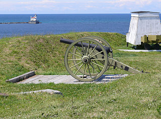
Amherstburg Royal Naval Dockyard was a Provincial Marine and then a Royal Navy yard from 1796 to 1813 in Amherstburg, Ontario, situated on the Detroit River. The yard comprised blockhouses, storehouses, magazine, wood yard and wharf. The yard was established in 1796 to support the Upper Canada Provincial Marine after Great Britain ceded a pre-existing shipyard on the Detroit River to the United States. Amherstburg Royal Naval Dockyard constructed four warships for the Lake Erie detachment of the Provincial Marine before and during the War of 1812. In 1813 the dockyard was abandoned and destroyed when the British retreated and never reopened. In 1928, the site was designated a National Historic Site of Canada.
The Battle of Malcolm's Mills was the last battle of the War of 1812 fought in the Canadas. A force of American mounted troops overran and scattered a force of Canadian militia. The battle was fought on November 6, 1814, near the village of Oakland in Brant County, Upper Canada, and was part of a series of battles fought by American Brigadier General Duncan McArthur on an extended raid into Upper Canada, known variously as McArthur's Raid or Dudley's Raid. Marching over 200 miles (320 km) into Canada, the Americans returned to Detroit on November 17 after 11 days of raiding the Ontario Peninsula.

Fort St. Joseph is a former British outpost on the southernmost point of St. Joseph Island in Ontario, Canada, on Lake Huron. The fort consisted of a blockhouse, powder magazine, bakery building, Indian council house and storehouse surrounded by a palisade.
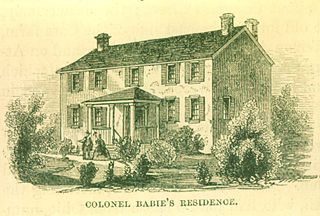
The François Bâby House is a historic residence located in Windsor, Ontario, Canada which was owned by the prominent local politician François Baby. The house is a two-storey, Georgian style, red brick house once known as La Ferme locally, and was a French-Canadian ribbon farm which was a long narrow tract fronting endwise on the Detroit River. The home itself has historical ties to the War of 1812 where it was used as a headquarters by both the American and British forces.
Fort Matachewan was a trading post set up by the Hudson's Bay Company in 1867, and is located 8 km north of the town of Matachewan, Ontario. This fort was primarily used for the fur trade, and as such the natives of the area often travelled to it to sell off their furs and pick up the staples of their diet. The fort was not a town site, but rather a large depot of stores. Eventually, a church was built on the grounds. Today the Fort is a crumbled relic of a time long past.

Fort Shelby was a military fort in Detroit, Michigan that played a significant role in the War of 1812. It was built by the British in 1779 as Fort Lernoult, and was ceded to the United States by the Jay Treaty in 1796. It was renamed Fort Detroit by Secretary of War Henry Dearborn in 1805.

Norfolk County in the Canadian province of Ontario consists of a long list of communities. Its four designated population centres are Simcoe, Port Dover, Delhi, and Waterford.
Point Frederick is a 41-hectare (101-acre) peninsula in Kingston, Ontario, Canada. The peninsula is located at the south end of the Rideau Canal where Lake Ontario empties into the St. Lawrence River. Point Frederick is bounded by the Cataraqui River to the west, the St. Lawrence River to the south, and Navy Bay to the east. The peninsula is occupied by the Royal Military College of Canada (RMC). Several of the buildings located on Point Frederick and the site of the old naval dockyard are national historic sites. Fort Frederick, at the south end of the peninsula, is a feature of the Kingston Fortifications National Historic Site of Canada.
Old Stone Fort was a fort that existed in 1814 in Rockport, Massachusetts during the War of 1812. It was also known as Sea Fensibles Barrack during its existence. Today, a plaque is located on the Transit Tower, which was built on the site of the fort. Stones from the former fort were used in the construction of the harbor's breakwater.

Fort Norfolk is a historic fort and national historic district located at Norfolk, Virginia. With the original buildings having been built between 1795 and 1809, the fort encloses 11 buildings: main gate, guardhouse, officers' quarters, powder magazine, and carpenter's shop. Fort Norfolk is the last remaining fortification of President George Washington's 18th century harbor defenses, later termed the first system of US fortifications. It has served as the district office for the U.S. Army Engineer District, Norfolk since 1923.

Fort Townshend is an archaeological site in St. John's, Newfoundland and Labrador that was designated a National Historic Site of Canada in 1951. The original military fort was built, as the headquarters of the British garrison, between 1775-1779, to secure St John's from attacks, from the French, as well as from American privateers, and it was abandoned in 1871. The great star-shaped citadel was one of the largest British fortifications in North America at the time. The Rooms which houses the Art Gallery, the Provincial Archives and the Provincial Museum, of Newfoundland and Labrador now stands on this site. During the planning and construction of the building much opposition was raised by archaeologists and historians.
