Related Research Articles
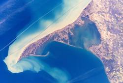
Long Point is a sand spit and medium-sized hamlet on the north shore of Lake Erie, part of Norfolk County in the province of Ontario, Canada.

The Humber River is a river in Southern Ontario, Canada. It is in the Great Lakes Basin, is a tributary of Lake Ontario and is one of two major rivers on either side of the city of Toronto, the other being the Don River to the east. It was designated a Canadian Heritage River on September 24, 1999.

Norfolk County is a rural single-tier municipality on the north shore of Lake Erie in Southwestern Ontario, Canada with a 2016 population of 64,044. The largest community in Norfolk County is Simcoe, Ontario with a 2016 population of 13,922. The other population centres are Port Dover, Delhi, Waterford and Port Rowan, and there are many smaller communities. For several years in the late 20th century, the county was merged with Haldimand County but the merged entity was dissolved in 2000.

The Rouge River is a river in Markham, Pickering, Richmond Hill and Toronto in the Greater Toronto Area of Ontario, Canada. The river flows from the Oak Ridges Moraine to Lake Ontario at the eastern border of Toronto, and is the location of Rouge Park, the only national park in Canada within a municipality. At its southern end, the Rouge River is the boundary between Toronto and southwestern Pickering in the Regional Municipality of Durham.

The Grand River is a large river in Southwestern Ontario, Canada. It also lies along the western fringe of the Greater Golden Horseshoe region of Ontario which overlaps the eastern portion of southwestern Ontario, sometimes referred to as Midwestern Ontario, along the length of this river. From its source near Wareham, Ontario, it flows south through Grand Valley, Fergus, Elora, Waterloo, Kitchener, Cambridge, Paris, Brantford, Caledonia, and Cayuga before emptying into the north shore of Lake Erie south of Dunnville at Port Maitland. One of the scenic and spectacular features of the river is the falls and Gorge at Elora.
Kettle Creek is a creek in Elgin County in southwestern Ontario, Canada that empties into Lake Erie at Port Stanley. It drains an area of 520 square kilometres (200 sq mi). Dodd Creek is the major tributary.
The Lynn River is a fresh water river located in Norfolk County in Southwestern Ontario, Canada. It empties into Lake Erie at Port Dover.

Delhi refers to both a former township and unincorporated community located off of the junction of Ontario Highways 59 and 3. Delhi is known as the "Heart of Tobacco Country." Prior to 1880, this community was known for its lumber industry. One of the Communities in Norfolk County, Ontario, Delhi had a population of 4,240 at the time of the 2016 Census.
Port Rowan is a town in Norfolk County, Ontario, Canada. It is located on Lake Erie, adjacent to Long Point. The lakeside community has a population of fewer than 1500 people and sports a number of traditional small businesses such as Twin's Ice Cream Parlour, which has been operating in the town for decades.

The Welland Canal has gone through many incarnations in its history. Today, five distinct canal-construction efforts are recognized. The retronym First Welland Canal is applied to the original canal, constructed from 1824 to 1829 and 1831 to 1833.

The Great Lakes Seaway Trail, formerly named and commonly known as the Seaway Trail, is a 518-mile (834 km) National Scenic Byway in the northeastern United States, mostly contained in New York but with a small segment in Pennsylvania. The trail consists of a series of designated roads and highways that travel along the Saint Lawrence Seaway—specifically, Lake Erie, the Niagara River, Lake Ontario, and the Saint Lawrence River. It begins at the Ohio state line in rural Erie County, Pennsylvania, and travels through several cities and villages before ending at the Seaway International Bridge northeast of the village of Massena in St. Lawrence County, New York. It is maintained by the non-profit Seaway Trail, Inc.

The geography of New York state varies widely. Most of New York is dominated by farms, forests, rivers, mountains, and lakes. New York's Adirondack Park is larger than any U.S. National Park in the contiguous United States. Niagara Falls, on the Niagara River as it flows from Lake Erie to Lake Ontario, is a popular attraction. The Hudson River begins near Lake Tear of the Clouds and flows south through the eastern part of the state without draining lakes George or Champlain. Lake George empties at its north end into Lake Champlain, whose northern end extends into Canada, where it drains into the Richelieu River and then the St. Lawrence. Four of New York City's five boroughs are on the three islands at the mouth of the Hudson River: Manhattan Island, Staten Island, and Brooklyn and Queens on Long Island.

Twelve Mile Creek is a waterway located on the Niagara Peninsula in the Regional Municipality of Niagara in Southern Ontario, Canada. Its headwaters are located in the town of Pelham, encompassing some of the most unspoiled and natural areas of Niagara area. The creek's lower reaches flow through urban areas of Thorold and St. Catharines, and have been heavily altered by human activity for almost two centuries.

Big Otter Creek is a waterway that empties into Lake Erie at Port Burwell, Ontario. It is 42 kilometres (26 mi) long, and the area of its drainage basin is 712 square kilometres (275 sq mi). The creek's headwaters are north of the Horseshoe Moraine, and its mouth is just west of the Long Point Conservation Area. Scenic bluffs line the valley as it passes through the moraine.
The South Norfolk Railway was incorporated in 1886, to construct a railway from Simcoe, Ontario to Port Rowan, Ontario.
Nanticoke Creek is a watercourse in Haldimand County, Ontario. It is approximately 15 kilometres (9.3 mi) long, emptying into Lake Erie approximately 15 km west of the mouth of the Grand River. The creek drains approximately 180 square kilometres (69 sq mi).
Big Creek is a watercourse in Norfolk County, Ontario. It is approximately 60 kilometres (37 mi) long. It empties into Lake Erie, at Port Rowan, at Long Point. Its watershed covers 730 square kilometres (280 sq mi), alternately 750 square kilometres (290 sq mi).
Venison Creek is the largest tributary to Big Creek, in the Long Point Region Conservation Area, on the north shore of Lake Erie, in Ontario, Canada.
Davis Creek is a tributary of the Lynn River, which empties into Lake Erie, and Port Rowan. It drains 28.88 square kilometres (11.15 sq mi). Unlike nearby Kent Creek, Davis Creek is poorly covered by forests.
The Horseshoe Moraine is the name for a series of moraines that cover much of southern Ontario, west of the Niagara Escarpment. A lobe of the horseshoe moraine abuts the well-known Oak Ridges Moraine in the extreme west of the headwaters of the Humber River.
References
- 1 2 3 "Executive Summary: Long Point Conservation Area" (PDF). Long Point Conservation Area . January 2008. Archived (PDF) from the original on 2018-12-15. Retrieved 2018-12-12.
Big Creek is the largest watershed in the Long Point Region with a total area of 750 square kilometres. The creek flows south through Delhi, where North Creek joins it. Venison Creek joins downstream of Walsingham before Big Creek enters Lake Erie near Port Rowan.
- ↑ John Kernaghan (2014-08-23). "Paddling down a lazy river — by kayak". Hamilton Spectator . Paris, Ontario. Archived from the original on 2016-11-01. Retrieved 2018-12-11.
It takes about 12 hours to travel the 40 kilometres of Big Creek, which passes through two conservation areas and the Big Creek Wildlife area near Port Rowan on Lake Erie.