Bon Echo Provincial Park is a provincial park in southeastern Ontario, Canada, approximately 6 kilometres (3.7 mi) north of Cloyne. The park is within township boundaries of both North Frontenac and Addington Highlands, roughly separated by Highway 41.
Bon Echo features several lakes, including Bon Echo Lake; Joeperry Lake, along Rainey Creek; and part of Mazinaw Lake, the seventh-deepest lake in Ontario. The southeastern shore of Mazinaw Lake features the massive 100-metre-high (330 ft) Mazinaw Rock, an escarpment rising out of the water, adorned with many native pictographs.
Nanabozho, a trickster from Ojibwe legend and cultural hero is the unofficial mascot of Bon Echo Park. [1] He is featured prominently in pictographs adorning the sides of the rock escarpment on Mazinaw Lake. The site of the Mazinaw pictographs was designated a National Historic Site of Canada in 1982. [2] [3]
The Bon Echo region –after enterprising lumbering companies came and went, along with the farming communities that accompanied them –was purchased in 1889 by Weston A. Price and his wife, who were inspired by Mazinaw Rock and the surrounding area. They named the area "Bon Echo" because of the acoustical properties of the Rock, which bounced sound across Mazinaw Lake. The Prices built a large hotel at the narrows, the Bon Echo Inn, which catered to the wealthy who were looking for a healthful retreat. Price banned alcohol on the premises due to strong religious beliefs and the Inn attracted primarily people who shared the Prices' beliefs. The hotel was also populated by a contingent of Methodist pastors, and attendance at Sunday church was required of those who stayed there.
After several successful years at the Inn, a personal tragedy compelled Dr. Price to sell his holdings at Bon Echo. He found buyers in Howard and Flora MacDonald Denison. Flora was both a successful business operator in Toronto and a vocal proponent of women's rights who founded, along with other feminists, the Canadian Suffrage Association. Years earlier the Denisons had attempted to purchase a cottage from Price, but instead had settled for a lot south of the Inn when Price was reluctant to sell to them. After obtaining the property for $15,000, they sent away the pastors and turned Bon Echo Inn into a haven for artists, poets, and writers, most notably James Thurber and members of the Group of Seven.
Although Walt Whitman had never visited Bon Echo, Flora admired Whitman's work so much that she commissioned a piece of his poetry to be chiseled into the face of the rock in foot-tall lettering, where it can still be seen. [4] The work was performed by two Aberdeen, Scotland stonemasons and took all of the summer of 1919 to complete.
After her death in 1921, the land and inn was inherited by Merrill Denison, her son and a very successful entrepreneur. He continued to operate the inn until the beginning of the Great Depression in 1929 along with his first wife, Muriel Denison, an author whose works include the "Susannah" series ( Susannah of the Mounties , et al.), made famous by the Shirley Temple film adaptions. After that, the inn was leased to the Leavens Brothers who operated it as a summer hotel, and other portions of the property were rented out for use as a boys' camp and other recreational purposes. In 1936, the inn and many outbuildings were destroyed in a fire started by lightning striking the bakehouse. The loss was not fully covered by insurance, and the inn was never rebuilt.
Merrill Denison continued to spend summers at Bon Echo, using it as a quiet location to write. Some of the cottages, including Dollywood and Greystones, remained in use as summer getaways for years, but financially the property was often a burden on the Denisons. In 1955, the Province of Ontario passed legislation allowing them to accept donations of land to form provincial parks. Although he could have made a substantial profit dividing and selling sections of the property as building lots, Denison's interests in conservation led him to donate the land to the province for the purpose of forming a park in 1959.
In 1965, Bon Echo Provincial Park officially opened. A plaque was placed at the narrows dedicating the park to Flora MacDonald Denison and Muriel Denison.
In 1956, Kay McCormick, Marnie Gilmour, David Fisher and Alan Bruce-Robertson paddled across Mazinaw Lake in a canoe on the Saturday of the Labour Day weekend, and climbed a rock outcropping subsequently named Birthday Ridge. On Sunday (Marnie's birthday), they climbed Front of the Pinnacle. This marked the first rock climbing on Mazinaw Rock. The Alpine Club of Canada maintains a hut on the lake, and Bon Echo rock climbing remains core to the ACC's Toronto Section [5] to this day.
Bon Echo's 400+ campsites in the Mazinaw and Hardwood Hills campgrounds are typical of those in the Ontario Parks system. Grassy or lightly wooded lots are set back from unpaved access roads and are backed by natural, untended land, which is generally conifer-deciduous forest. Both campgrounds host a number of RV-accessible lots. Electricity is also available to 130 campsites. All sites are located close to a source of running water, as well as a latrine or flush toilet. Comfort stations with washrooms, showers, and laundry facilities are available in each campground area. There are also radio-free areas, a visitor centre, and a gift shop/café.
In addition, accommodation in heated yurts is available in the Sawmill Bay camping area, [6] as well as a number of cabins, most of which are located on Bon Echo Lake, west of Highway 41. The yurts and cabins are an alternative to tenting or RVs, accommodating up to 5 or 6 and providing a more protected environment for less hardy visitors.
Cutting and collecting firewood is prohibited on these sites to prevent environmental disturbances or damage. Firewood must be purchased at camp offices. Due to the emerald ash borer and other invasive species, moving firewood from regulated areas to non-regulated areas is not permitted without a movement certificate from the CFIA.
Bon Echo also offers backcountry camping along the Abes and Essens Trail. This trail in the northern reaches of the park hosts five campsites, each equipped with a picnic table, stone firepit, and dedicated outdoor box privy ("thunderbox"). Unlike other areas of the park, none of these sites have access to treated water, electricity, or any other park service. Disturbing these sites is also discouraged, although the collecting of fallen deadwood for a campfire is tolerated if done carefully.
Augmenting the ruggedness of the experience, Abes and Essens is regarded as a strenuous trail. The terrain is, in places, very rough and uneven, often with shield rock jutting up as on the Bruce Trail. Depending on the loops and paths one takes, the hike will take between 2 and 7 hours. The trail features three loops of four km (2.5 mi), nine km (5.6 mi) and 17 km (11 mi), which intersect at various points, allowing navigation of the trail in many ways. The paths are not bold, preserving the ecology of the trail, and can be confusing at times, although the way is marked by flags on particularly difficult sections. Due to the length and difficulty of the trail, it is not recommended for the ill-prepared (or overpacked) camper, nor the unfit or inexperienced day-hiker.
Other, less strenuous hiking trails include the Shield Trail and the High Pines Trail, as well as the Clifftop Trail that leads up along the top of the Mazinaw Rock, providing views from its designated viewing areas above the narrows of Mazinaw Lake.[ citation needed ]
It is also possible to rent self-propelled water craft to explore the lakes and waterways of the park.
Bon Echo Provincial Park has beaches along Mazinaw Lake, including North Beach (at the southern end of Upper Mazinaw Lake), Main Beach and South Beach (both at the northern end of Lower Mazinaw Lake). The beach waters are generally at their warmest in August, and swimmer's itch is not uncommon.
44°56′28″N77°12′20″W / 44.94111°N 77.20556°W
The Toronto chapter of the Alpine Club of Canada maintains a climbing hut as a base for climbing activities in the park. This is a day-use hut with no sleeping facilities. It is equipped with propane-powered lamps and stovetops and a wood-burning fireplace for heating and drying clothes. There are numerous tent sites on the property for use by Alpine Club members and guests during summer weekends. Unlike most other alpine huts managed by the Alpine Club, the ACC owns the land on which the hut is built. The hut can be reached by boat from the park's dock on Mazinaw Lake.
Several of the lakes on the Abes and Essens trail are stone-bottomed, hewn by glacial procession. They are relatively free of detritus and sand, and as such, the water is clear and cold. Consequently, these lakes are relatively devoid of fish and plant species found elsewhere throughout the park. Small fish can be observed, but generally only closer to the shores of these lakes, or clustered around the islands found therein.
In most lakes, lake trout, yellow pickerel, smallmouth and largemouth bass, lake whitefish, and northern pike can all be found. Additionally, in the more secluded areas one may see white-tailed deer, moose, black bear, red fox, beaver, and raccoons. Commonly seen mammals include eastern cottontail rabbits, eastern chipmunks, red squirrels, gray squirrels, and voles. It also hosts Ontario's only lizard, the five-lined skink.
Addington Highlands is a township in central eastern Ontario, Canada, in the County of Lennox and Addington. Bon Echo Provincial Park is located primarily in Addington Highlands.
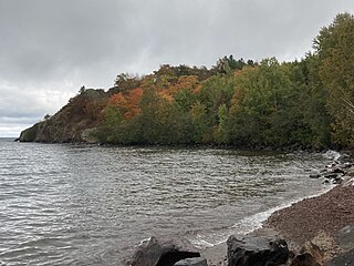
Lake Superior Provincial Park is one of the largest provincial parks in Ontario, covering about 1,550 square kilometres (600 sq mi) along the northeastern shores of Lake Superior between Sault Ste. Marie and Wawa in Algoma District in Northeastern Ontario, Canada. Ontario Highway 17 now runs through the park. When the park was established by Ontario in 1944, there was no road access.
Pancake Bay Provincial Park was established in 1968 by Ontario Parks. It is a recreation-class provincial park created to help preserve the fragile beach dune ecology. There are 325 campsites, including 160 with electricity. There are three comfort stations. Yurt camping is available in the park. Group camping sites are also available.
Charleston Lake Provincial Park is located on Charleston Lake near Athens, Ontario, Canada, in the township of Leeds and the Thousand Islands.
Garibaldi Provincial Park, also called Garibaldi Park, is a wilderness park located on the coastal mainland of British Columbia, Canada, 70 kilometres (43.5 mi) north of Vancouver. It was established in 1920 and named a Class A Provincial Park of British Columbia in 1927. The park is a popular destination for outdoor recreation, with over 30,000 overnight campers and over 106,000 day users in the 2017/2018 season.
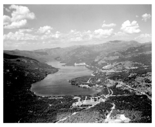
Lake Mazinaw is a lake in the Addington Highlands north of Kaladar in Eastern Ontario. The lake is situated on the upper Mississippi River. It has a perimeter of 49 km (30 mi) and averages 41 m (135 ft) in depth with a maximum depth of 145 m (476 ft), making it the seventh-deepest lake in Ontario, including the Great Lakes. There is a narrows which divides the lake into two sections: South Mazinaw, and North Mazinaw, with North Mazinaw being larger and deeper.
Kikomun Creek Provincial Park is a provincial park in British Columbia, Canada.
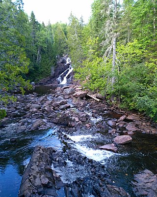
Rainbow Falls Provincial Park is a recreation-class provincial park within the Ontario Parks system. This 575-hectare (1,421-acre) park consists of two non-contiguous parts: Whitesand Lake campground in the main park, and the historic Rossport Campground, east of the fishing community of Rossport, Ontario, which provides campsites along the rough and rocky shorelines of Lake Superior.
King's Highway 41, commonly referred to as Highway 41, is a provincially maintained highway in the Canadian province of Ontario. The 159.6-kilometre (99.2 mi) highway travels in a predominantly north–south direction across eastern Ontario, from Highway 7 in Kaladar to Highway 148 in Pembroke. The majority of this distance crosses through a rugged forested region known as Mazinaw Country. However, the route enters the agricultural Ottawa Valley near Dacre. A significant portion of Highway 41 follows the historic Addington Colonization Road, built in 1854.
Lake St. Peter Provincial Park is a recreation-class provincial park in the municipality of Hastings Highlands, Hastings County, Ontario, Canada. It is operated by the Ontario Parks branch of the Ontario Ministry of Natural Resources and Forestry.
Moose Mountain Provincial Park is a provincial park, in south-eastern Saskatchewan about 24 kilometres (15 mi) north of the town of Carlyle on the Moose Mountain Upland. It is one of Saskatchewan's few parks with a community inside the park as there are several subdivisions with both year-round and seasonal residents. The village of Kenosee Lake is completely surrounded by the park but is not part of the park.
Christina Lake is an unincorporated recreational area in the Boundary Country of the West Kootenay region of British Columbia, Canada. It is located on Crowsnest Highway, 20 kilometres (12 mi) east of Grand Forks and 73 kilometres (45 mi) southwest of Castlegar.
Balsam Lake Provincial Park is a provincial park located in south-central Ontario, Canada, on Balsam Lake. The park is situated along the Trent-Severn Waterway, a few kilometres southwest of Coboconk. It is an all-seasons recreation area offering camping, boating and fishing, and while closed in winter it is also used for skiing and snowshoeing.
Pinery Provincial Park is a provincial park located on Lake Huron near Grand Bend, Ontario. It occupies an area of 25.32 square kilometres. It is a natural environment-class Provincial Park created to help preserve oak savannah and the beach dune ecology. It has 1,275 sites of which 404 have electrical hookups. These include the yurt camping area and the group camping sites.
Meadow Lake Provincial Park is a northern boreal forest provincial recreational park along the Waterhen and Cold Rivers in the Canadian province of Saskatchewan. The park was founded on 10 March 1959, is the largest provincial park in Saskatchewan, and encompasses over 25 lakes in an area of 1,600 km2 (620 sq mi). The park was named "Meadow Lake" after the city of Meadow Lake and Meadow Lake. The city and the lake are not in the park and are located about 40 kilometres (25 mi) south-east of the nearest park entrance, which is about 5 kilometres (3.1 mi) north of Dorintosh. The length of the park stretches about 113 kilometres (70 mi) from Cold Lake on the Saskatchewan / Alberta border in the west to the eastern shore of Waterhen Lake in the east.
Blackstrap Provincial Park is a provincial park in the Canadian province of Saskatchewan in the RM of Dundurn No. 314. Prior to the park's establishment in 1986, it was a provincial recreation site. The park runs along the eastern shore of Blackstrap Lake and consists of a conservation area, campground, beaches, Mount Blackstrap, cross country ski trails, biking and hiking trails, and several picnicking areas. It is about 8.5 kilometres (5.3 mi) east of the town of Dundurn and accessed via Highway 211. Mount Blackstrap is a man-made mountain built as a ski hill for the 1971 Canada Winter Games. It continued to operate as a ski hill until 2007.
Echo Valley Provincial Park is a provincial park in the Canadian province of Saskatchewan, located west of the town of Fort Qu'Appelle in the Qu'Appelle Valley between Echo Lake and Pasqua Lake in the RM of North Qu'Appelle No. 187. The three main roads to access the park are Highways 210, 56, and 727.
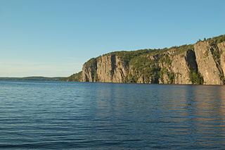
Mazinaw Rock is a 100-metre (330 ft) high cliff in the Addington Highlands, just north of Kaladar, south-central Ontario, Canada. It stretches for 1.5 kilometres (0.9 mi) along Mazinaw Lake, and is a landmark in the Bon Echo Provincial Park that draws the attention of many campers and cottagers. The lake's depth reaches 145 metres (476 ft), making it the third deepest lake in Ontario besides the Great Lakes. The rock is composed of granite and black dykes. The quality of the rock varies from good on the more popular routes to bad on the less used routes.
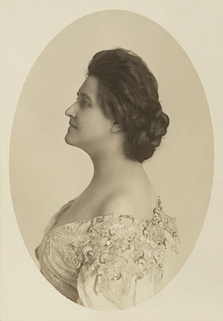
Flora MacDonald Denison was a Canadian activist, journalist, and businesswoman known for her leadership in the Canadian suffragist movement and her stewardship of Bon Echo Provincial Park in Ontario.
Makwa Lake Provincial Park is a recreational provincial park in the west-central region of the Canadian province of Saskatchewan in the transition zone between parkland and boreal forest. The park was established in 1986 and is centred around the lakes of Big Jumbo, Little Jumbo, and Makwa. Prior to its establishment, the park was a provincial recreation site. The main entrance to Makwa Lake Park is at the south-east corner of Makwa Lake about 3 kilometres (1.9 mi) west of the village of Loon Lake. Access is from Highway 699.