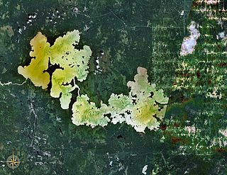
Lake Abitibi is a shallow lake in northeastern Ontario and western Quebec, Canada. The lake, which lies within the vast Clay Belt, is separated in two distinct portions by a short narrows, making it actually two lakes. Its total area is 931 square kilometres (359 sq mi), and net area 903 square kilometres (349 sq mi). The lake is shallow and studded with islands. Its shores and vicinity are covered with small timber.

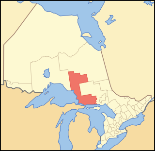
Algoma District is a district and census division in Northeastern Ontario in the Canadian province of Ontario.

Picea mariana, the black spruce, is a North American species of spruce tree in the pine family. It is widespread across Canada, found in all 10 provinces and all 3 territories. It is the official tree of the province of Newfoundland and Labrador and is that province's most numerous tree. The range of the black spruce extends into northern parts of the United States: in Alaska, the Great Lakes region, and the upper Northeast. It is a frequent part of the biome known as taiga or boreal forest.

The Amable du Fond River is a river in Nipissing District, in Northern Ontario, Canada.

The New England-Acadian forests are a temperate broadleaf and mixed forest ecoregion in North America that includes a variety of habitats on the hills, mountains and plateaus of New England and New York State in the Northeastern United States, and Quebec and the Maritime Provinces of Eastern Canada.

The La Cloche Silhouette Trail is a 78-kilometre (48 mi) backpacking loop across the white quartzite peaks of the La Cloche mountain range. The trail is situated in Killarney Provincial Park, Ontario, Canada. The trail is named for Group of Seven painter Franklin Carmichael's painting "La Cloche Silhouette." Wildlife can be seen throughout the trail - black bears, moose, wolverines, mountain lions, lynx, fishers, snakes, porcupines, beavers, river otters, among other animals, can be encountered at various points along the way.
The Temagami River, formerly spelled as Timagami River, is a river in the Nipissing District of Ontario, Canada, in the Temagami region. Its source is Lake Temagami and flows through Cross Lake and Red Cedar Lake. It flows into the Sturgeon River at the community of River Valley.

The Gull River is a river in Thunder Bay District in Northwestern Ontario, Canada. The river is in the Great Lakes Basin and is a tributary of Lake Nipigon.

Aiguebelle National Park(French: Parc national d'Aiguebelle) is a provincial park in Quebec, Canada. It is located in western Quebec in the Abitibi-Témiscamingue region some 50 km north-east of Rouyn-Noranda, 50 km west of Amos, Quebec, 100 km north west of Val-d'Or, Quebec, and about 50 km due west of Lake Hebecourt. The park has a surface area of 268,3 km2.

Kettle Lakes Provincial Park is a provincial park in northeastern Ontario, about 30 kilometres (19 mi) east of Timmins. It is administered by Ontario Parks, which classifies it as a recreation park.

The eastern forest–boreal transition is a temperate broadleaf and mixed forests ecoregion of North America, mostly in eastern Canada. It is a transitional zone or region between the predominantly coniferous Boreal Forest and the mostly deciduous broadleaf forest region further south.
Killarney Lakelands and Headwaters Provincial Park is a provincial park in central Ontario, Canada. Located primarily within the Sudbury District with a small portion located in the Walden area of Greater Sudbury, the park was created in 2006 as an expansion of the adjacent Killarney Provincial Park.

The Western Great Lakes forests is a terrestrial ecoregion as defined by the World Wildlife Fund. It is within the temperate broadleaf and mixed forests biome of North America. It is found in northern areas of the United States' states of Michigan, Wisconsin and Minnesota, and in southern areas of the Canadian province of Manitoba and northwestern areas of the province of Ontario.

Lac-Témiscouata National Park is a provincial park located in Quebec, Canada south of the Saint Lawrence River, near the border with New Brunswick. It contains Lake Témiscouata, which is "the second-largest lake south of the Saint Lawrence River" within some unspecified area, perhaps within Quebec, with a length of around 40 km (25 mi). Touladi River can also be found within the park's boundaries.

The Ecological regions of Quebec are regions with specific types of vegetation and climates as defined by the Quebec Ministry of Forests, Wildlife and Parks. Given the size of this huge province, there is wide variation from the temperate deciduous forests of the southwest to the arctic tundra of the extreme north.
Cumberland Island, also known as Pine Island, is a small island in the Saskatchewan River Delta in the east-central region of the Canadian province of Saskatchewan. The Saskatchewan River Delta is one of the largest active inland deltas in North America. Cumberland Island is situated between Cumberland Lake to the north and the Saskatchewan River to the south. The Tearing River runs along the eastern edge of the island and Bigstone River along the western edge. The Bigstone River separates Cumberland Island from Spruce Island to the west. The island is in the Mid-Boreal Lowland region, which consists of mixed coniferous and deciduous forests of white and black spruce, jack pine, tamarack, trembling aspen, balsam poplar, and balsam fir.
St. Raphael Provincial Park is a provincial park in northern Ontario, Canada, roughly halfway between Sioux Lookout and Pickle Lake, straddling the boundary of Kenora and Thunder Bay Districts. It was established on May 22, 2003, and provides backcountry canoeing and camping opportunities.
The Turtle River–White Otter Lake Provincial Park is a large provincial park in Kenora and Rainy River Districts, roughly located between Ignace and Atikokan, Ontario, Canada. It has been recognized as a "natural area with unique biophysical, recreational, and cultural attributes."
Eagle-Dogtooth Provincial Park is a provincial park in Kenora District, Ontario, Canada. It protects a series of lakes and streams between Eagle Lake in the east and Dogtooth Lake in the west. With its irregular terrain of land and water, the park has high fishing, tourism and recreational values.
Matinenda Provincial Park is a provincial park in Algoma District, Ontario, Canada. It is located 15 kilometres (9.3 mi) north of the Town of Blind River. It is a large, elongated, irregularly shaped park, centered around Matinenda Lake.


