
Algonquin Provincial Park is an Ontario provincial park located between Georgian Bay and the Ottawa River, mostly within the Unorganized South Part of Nipissing District. Established in 1893, it is the oldest provincial park in Canada. Additions since its creation have increased the park to its current size of about 7,653 km2 (2,955 sq mi). The park is contiguous with several smaller, administratively separate provincial parks that protect important rivers in the area, resulting in a larger total protected area.

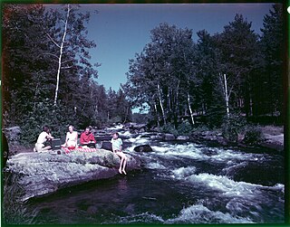
The Madawaska River is a river in the Saint Lawrence River drainage basin in Ontario, Canada. The river is 230 km (143 mi) long and drains an area of 8,470 km2 (3,270 sq mi). Its name comes from an Algonquian band of the region known as "Matouweskarini", meaning "people of the shallows".

The York River is a river in Renfrew County, Hastings County and Haliburton County in Ontario, Canada. The river is in the Saint Lawrence River drainage basin, and flows from the southern extension of Algonquin Provincial Park to the Madawaska River.

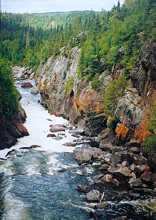
The Petawawa River is a river in the Saint Lawrence River drainage basin in Nipissing District and Renfrew County in eastern and northeastern Ontario, Canada. The river flows from Algonquin Provincial Park to the Ottawa River at the town of Petawawa, and is only one of two major tributaries of the Ottawa River to flow completely freely. The river's name comes from the Algonquian for "where one hears a noise like this", which refers to its many rapids.

The Opeongo River is a river in the Saint Lawrence River drainage basin in Nipissing District in northeastern Ontario, Canada. The river is entirely within Algonquin Provincial Park and Opeongo River Provincial Park, except for a small portion around Victoria Lake, and is a left tributary of the Madawaska River.
The White River is a tributary of Lake Superior in Thunder Bay District, Ontario, Canada. It starts at Negwazu Lake and flows in a predominantly western direction to Lake Superior, passing through the Township of White River.

Secondary Highway 523, commonly referred to as Highway 523, is a provincially maintained highway in the Canadian province of Ontario. The highway is a 20.0-kilometre (12.4 mi) north–south route in Nipissing District which follows the historic Madawaska Colonization Road. The highway begins at the Nipissing–Hastings boundary, where it continues south to Highway 127. It ends at Highway 60 in the village of Madawaska. The route was assumed as a provincial highway in 1956.
Opeongo River Provincial Park is a waterway park in Nipissing District in northeastern Ontario, Canada. It incorporates those portions of the Opeongo River from its exit from Algonquin Provincial Park to the river's mouth at the Madawaska River, except for a small portion around Victoria Lake. The park has two access points: from Ontario Highway 60 west of the community of Madawaska; and the Shall Lake access point, north of Victoria Lake, in Algonquin Provincial Park.

Bonnechere River Provincial Park is located along the Bonnechere River in southern Ontario, Canada. A 23 km (14 mi) long section of the Bonnechere River, starting at the Algonquin Provincial Park boundary and terminating at Bonnechere Provincial Park, has been protected as a waterway provincial park. This scenic portion of the river is particularly suitable for canoe camping. It is a non-operating park, meaning no fees are charged and no staff are present with only a few services offered.

South Algonquin is a township municipality in Nipissing District, Ontario, Canada. Located south of Algonquin Provincial Park, it is the sole populated portion of the district that lies south of the traditional dividing line between Northern Ontario and Southern Ontario and is closer connected to Renfrew County as opposed to the core portions of Nipissing District.
Upper Madawaska River Provincial Park is a waterway-class provincial park on the Madawaska River in the municipality of South Algonquin in Nipissing District, Ontario, Canada. The park consists of a strip of land along both shores of the Madawaska River from the communities of Whitney to Madawaska. It is upstream and north of the Lower Madawaska River Provincial Park.
King's Highway 41, commonly referred to as Highway 41, is a provincially maintained highway in the Canadian province of Ontario. The 159.6-kilometre (99.2 mi) highway travels in a predominantly north–south direction across eastern Ontario, from Highway 7 in Kaladar to Highway 148 in Pembroke. The majority of this distance crosses through a rugged forested region known as Mazinaw Country. However, the route enters the agricultural Ottawa Valley near Dacre. A significant portion of Highway 41 follows the historic Addington Colonization Road, built in 1854.

Little Abitibi Provincial Park is a non-operating provincial park 66 kilometres (41 mi) north of Cochrane, Ontario. It holds a network of small lakes which run into the Little Abitibi River. The Little Abitibi River runs about 120 kilometres (75 mi) up into the Abitibi Canyon, where the Ontario Power Generation dams the river at Fraserdale, an abandoned railway town.
Source Lake is a small lake in geographic Canisbay and Peck townships in the Unorganized South part of Nipissing District in Northeastern Ontario, Canada. It lies in southern Algonquin Provincial Park and is part of the Saint Lawrence River drainage basin. The river is the source of the Madawaska River, which flows via the Ottawa River to the Saint Lawrence River.
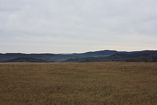
The Opeongo Hills are a range of hills in Southern Ontario, near Algonquin Provincial Park. The hills stretch from Opeongo Lake in Algonquin Park in the west, along the Madawaska and Opeongo Rivers, towards the Opeongo Colonization Road, and extending towards the Deacon Escarpment, Bonnechere, Ontario, and Dacre in the east. To the east of the Opeongo Hills lie the Madawaska River valley, the Mississippi River Valley, and the Ottawa-Bonnechere Graben along the Ottawa River. Its tallest peak is roughly 7 km northeast of Highway 60. At roughly 586 meters, it is the tallest point in Southern Ontario. The community of Foymount is one of the highest settlements in Southern Ontario.
The Little Madawaska River is a river in the Saint Lawrence River drainage basin in the Unorganized South Part of Nipissing District in northeastern Ontario, Canada. The river is entirely within Algonquin Provincial Park, and is a right tributary of the Petawawa River and not a tributary of the nearby Madawaska River.
Rushing River Provincial Park is 20 kilometres (12 mi) southeast of Kenora, Ontario, Canada. It is a family campground at the mouth of the Rushing River where it enters Dogtooth Lake. It is a gateway to Eagle-Dogtooth Provincial Park, that borders on its east side.

The Centennial Lake Provincial Nature Reserve is a provincial park located in the municipality of Greater Madawaska, Renfrew County, in Eastern Ontario, Canada. The 530-hectare (1,300-acre) reserve was created in 1989 and is managed by Ontario Parks.
Egan Chutes Provincial Park is located 15 km (9.3 mi) east of Bancroft, Ontario, Canada. It was established as a provincial park in 1989 but is a non-operating park. Egan chutes is classified as a nature reserve, protecting a section of the York River.


