
The Wyandot people are Indigenous peoples of the Northeastern Woodlands of North America, and speakers of an Iroquoian language, Wyandot.

Fort Ancient is a name for a Native American culture that flourished from c. 1000–1750 CE and predominantly inhabited land near the Ohio River valley in the areas of modern-day southern Ohio, northern Kentucky, southeastern Indiana and western West Virginia. Although a contemporary of the Mississippian culture, they are often considered a "sister culture" and distinguished from the Mississippian culture. While far from agreed upon, there is evidence to suggest that the Fort Ancient Culture were not the direct descendants of the Hopewellian Culture. It is suspected that the Fort Ancient Culture introduced maize agriculture to Ohio. The Fort Ancient Culture were most likely the builders of the Great Serpent Mound. Recent archeological study and carbon dating suggests that Alligator Mound in Granville also dates to the Fort Ancient era, rather than the assumed Hopewell era. It is believed that neither the Serpent or Alligator Mounds are burial locations, but rather served as ceremonial effigy sites.

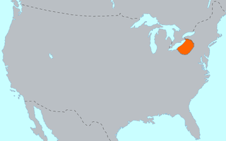
The Neutral Nation was a tribal confederation of Iroquoian peoples. Its heartland was in the floodplain of the Grand River in what is now Ontario, Canada. At its height, its wider territory extended toward the shores of lakes Erie, Huron, and Ontario, as well as the Niagara River in the east. To the northeast were the neighbouring territories of Huronia and the Petun Country, which were inhabited by other Iroquoian confederacies from which the term Neutrals Attawandaron was derived. The five nation Iroquois Confederacy was across Lake Ontario to the southeast.
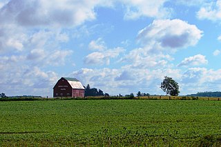
Southwold is a township in Elgin County, in Ontario, Canada, located on the north shore of Lake Erie. It is a rich agricultural zone producing predominantly corn and soybeans. It is part of the London census metropolitan area.

Crawford Lake Conservation Area is a conservation area owned and operated by Conservation Halton near the community of Campbellville in Milton, Halton, Ontario, Canada. It is categorized as a regional environmentally sensitive area, an Ontario Area of Natural and Scientific Interest, and part of the Niagara Escarpment world biosphere reserve. The conservation area contains Crawford Lake, a reconstructed Iroquoian village, and several hiking trails.
The Erie people were Indigenous people historically living on the south shore of Lake Erie. An Iroquoian group, they lived in what is now western New York, northwestern Pennsylvania, and northern Ohio before 1658. Their nation was decimated in the mid-17th century by five years of prolonged warfare with the powerful neighboring Iroquois for helping the Huron in the Beaver Wars for control of the fur trade.
SunWatch Indian Village / Archaeological Park, previously known as the Incinerator Site, and designated by the Smithsonian trinomial 33-MY-57, is a reconstructed Fort Ancient Native American village next to the Great Miami River. The dwellings and site plan of the 3-acre (1.2 ha) site are based on lengthy archeological excavations sponsored by the Dayton Society of Natural History, which owns and operates the site as an open-air museum. Because of its archaeological value, the site was listed in 1974 on the National Register of Historic Places. Since that time, as the many years of archaeological research at the site have led to important findings about the Fort Ancient culture, SunWatch Indian Village was designated in 1990 as a National Historic Landmark.

Town Creek Indian Mound is a prehistoric Native American archaeological site located near present-day Mount Gilead, Montgomery County, North Carolina, in the United States. The site, whose main features are a platform mound with a surrounding village and wooden defensive palisade, was built by the Pee Dee, a South Appalachian Mississippian culture people that developed in the region as early as 980 CE. They thrived in the Pee Dee River region of North and South Carolina during the Pre-Columbian era. The Town Creek site was an important ceremonial site occupied from about 1150—1400 CE. It was abandoned for unknown reasons. It is the only ceremonial mound and village center of the Pee Dee located within North Carolina.

The Eaker site (3MS105) is an archaeological site on Eaker Air Force Base near Blytheville, Arkansas, that was declared a National Historic Landmark in 1996. The site is the largest and most intact Late Mississippian Nodena phase village site within the Central Mississippi Valley, with archaeological evidence indicating a palisaded village some 50 acres (20 ha) in size, with hundreds of structures. The site's major period of occupation was 1350–1450 CE, although evidence of occupation dates back to 600 CE. The site is also hypothesized to have been occupied by the Quapaw prior to a migration further south, after which they made contact with Europeans in the late 17th century.

The Petun, also known as the Tobacco people or Tionontati, were an indigenous Iroquoian people of the woodlands of eastern North America. Their last known traditional homeland was south of Lake Huron's Georgian Bay, in what is today's Canadian province of Ontario

Molavėnai is a small village in the Raseiniai district municipality, Lithuania.

Moel y Gaer is an Iron Age hillfort located on a summit at the southern end of Halkyn Mountain, overlooking the village of Rhosesmor, Flintshire, Wales. It is a well-preserved hillfort overlooking the Dee Estuary. Excavations in the early 1970s revealed a sequence of defensive structures made of timber and several phases of building work inside the ramparts.

Old Town is an archaeological site in Williamson County, Tennessee near Franklin. The site includes the remnants of a Native American village and mound complex of the Mississippian culture, and is listed on the National Register of Historic Places (NRHP) as Old Town Archaeological Site (40WM2).

The Museum of Ontario Archaeology is a museum located in northwest London, Ontario, Canada. It is dedicated to the study and public interpretation of over 11,000 years of human history in Ontario. It is adjacent to a reconstruction of the Lawson Site, a 16th-century pre-contact Attawandaron People's village. The museum offers permanent and temporary gallery space, a theatre, a classroom and children's activity space, along with tours of the reconstructed village.
Smith Pagerie Site is an archaeological site located at Ephratah in Fulton County, New York, US. It is also known as Las. 11–4, New York State Office of Parks, Recreation, and Historic Preservation Unique Site No. A035-04-0002. It is one of three Mohawk Indian village sites excavated by the archaeologist Robert E. Funk in 1969–1970.

The "Jean-Baptiste Lainé" or Mantle Site in the town of Whitchurch–Stouffville, north-east of Toronto, Ontario, Canada, is the largest and most complex ancestral Wendat-Huron village to be excavated to date in the Lower Great Lakes region. The site's southeastern access point is at the intersection of Mantle Avenue and Byers Pond Way.

Caughnawaga Indian Village Site is an archaeological site located just west of Fonda in Montgomery County, New York. It is the location of a 17th-century Mohawk nation village. One of the original Five Nations of the Iroquois League, or Haudenosaunee, the Mohawk lived west of Albany and occupied much of the Mohawk Valley. Other Iroquois nations were located west of them and south of the Great Lakes.

The site of Ebsbury, in Wiltshire, England, includes the remains of an Iron Age enclosed settlement, field system and possible hill fort, and a Romano-British enclosed settlement.

Codford Circle, also known as Wilsbury Ring, Woldsbury, and possibly Oldbury Camp, is a neolithic hill top enclosure or possible hillfort located on the summit of Codford Hill, a chalk promontory of Salisbury Plain, near to the village and civil parish of Codford, in Wiltshire, England.

The Taskigi Mound or Mound at Fort Toulouse – Fort Jackson Park (1EE1) is an archaeological site from the South Appalachian Mississippian Big Eddy phase. It is located on a 40 feet (12 m) bluff at the confluence of the Coosa and Tallapoosa rivers where they meet to form the Alabama River, near the town of Wetumpka in Elmore County, Alabama.
