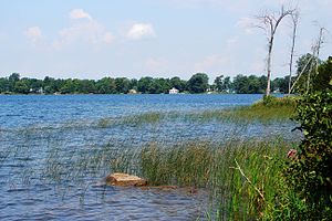
The Bay of Quinte is a long, narrow bay shaped like the letter "Z" on the northern shore of Lake Ontario in the province of Ontario, Canada. It is just west of the head of the Saint Lawrence River that drains the Great Lakes into the Gulf of Saint Lawrence. It is located about 200 kilometres (120 mi) east of Toronto and 350 kilometres (220 mi) west of Montreal.

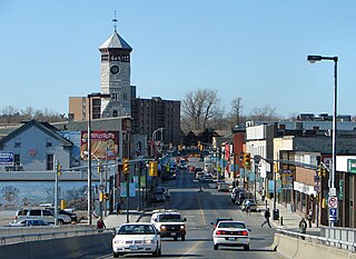
Belleville is a city in Ontario, Canada situated on the eastern end of Lake Ontario, located at the mouth of the Moira River and on the Bay of Quinte. Belleville is between Ottawa and Toronto, along the Quebec City-Windsor Corridor. Its population as of the 2021 Canadian census was 55,071. It is the seat of Hastings County, but politically independent of it, and is the centre of the Bay of Quinte Region.
Trenton is a large community in Central Ontario in the municipality of Quinte West, Ontario, Canada. Located on the Bay of Quinte, it is the starting point for the Trent-Severn Waterway, which continues northwest to Peterborough and eventually Port Severn on Georgian Bay.
King's Highway 33, commonly referred to as Highway 33 or Loyalist Parkway, is a provincially maintained highway in the Canadian province of Ontario. The route begins at Highway 62 in Bloomfield and travels east to the Collins Bay Road junction at Collins Bay in the city of Kingston, a distance of 60.9 kilometres (37.8 mi). The highway continues farther east into Kingston as Bath Road, ending at the former Highway 2, now Princess Street. Highway 33 is divided into two sections by the Bay of Quinte. The Glenora Ferry service crosses between the two sections just east of Picton, transporting vehicles and pedestrians for free throughout the year.

Prince Edward County (PEC) is a single-tier municipality in southern Ontario, Canada. Its coastline on Lake Ontario’s northeastern shore is known for Sandbanks Provincial Park, sand beaches, and limestone cliffs. The Regent Theatre, a restored Edwardian Opera House, sits at the heart of the town of Picton on the Bay of Quinte. Nearby Macaulay Heritage Park highlights local history through its 19th-century buildings. In 2016, Prince Edward County had a census population of 24,735. Prince Edward County is a single-tier municipality and a census division of the Canadian province of Ontario.

Quinte West is a city, geographically located in but administratively separated from Hastings County, in Southern Ontario, Canada. It is on the western end of the Bay of Quinte on Lake Ontario. The Lake Ontario terminus of the Trent–Severn Waterway is in the municipality.

Eastern Ontario is a secondary region of Southern Ontario in the Canadian province of Ontario. It occupies a wedge-shaped area bounded by the Ottawa River and Quebec to the northeast and east, the St. Lawrence River and New York to the south, and Northern Ontario and Central Ontario to the west and northwest.

Central Ontario is a secondary region of Southern Ontario in the Canadian province of Ontario that lies between Georgian Bay and the eastern end of Lake Ontario.

The Barron River is a river in the Saint Lawrence River drainage basin in Nipissing District and Renfrew County, Ontario, Canada. It flows from Clemow Lake in northern Algonquin Provincial Park and joins the Petawawa River, whose southern branch it forms, in the municipality of Laurentian Hills, near the municipality of Petawawa.
The Black Sturgeon River is a river in Thunder Bay District, Northwestern Ontario, Canada, located west of the Nipigon River, that flows to Lake Superior.
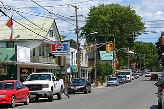
Wellington is an unincorporated place and community in Prince Edward County in eastern Ontario, Canada. It has a population of 1,932 according to the 2016 Census. The community is located on the shore of both Lake Ontario and West Lake in the southwest of the county. Sandbanks Beach, the northernmost of Sandbanks Provincial Park's beaches, is located in the Village of Wellington, where it is called Wellington Rotary Beach.

The North Shore of Lake Superior runs from Duluth, Minnesota, United States, at the western end of the lake, to Thunder Bay and Nipigon, Ontario, Canada, in the north, to Sault Ste. Marie, Ontario in the east. The shore is characterized by alternating rocky cliffs and cobblestone beaches, with forested hills and ridges through which scenic rivers and waterfalls descend as they flow to Lake Superior.

Sandbanks Provincial Park is a provincial park located on Lake Ontario in Prince Edward County near Picton, Ontario, Canada. The park is considered one of the best sandy beaches in Ontario and contains the largest bay-mouth barrier dune formation in the world. The 1,550.87-hectare (3,832.3-acre) park was established in 1970 and operates year round. Birdwatching, camping, cycling, fishing, and swimming are among the activities available in the park.
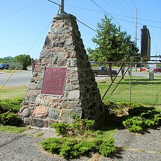
Carrying Place is a community straddling the Quinte West and Prince Edward County border that serves as a gateway to Prince Edward County, Ontario, Canada. Situated northwest of Picton and just south of Trenton, it was named for its location on the portage between the Bay of Quinte and Weller's Bay on Lake Ontario. The Loyalist Parkway passes through the community.
Skootamatta Lake is a lake in the Lake Ontario drainage basin in Addington Highlands, Lennox and Addington County, Ontario, Canada. It is 2.7 kilometres (1.7 mi) west of Cloyne, and Bon Echo Provincial Park is located just to the north. The lake's name is thought to come from Ojibwa words meaning "burnt shoreline".
King's Highway 62, commonly referred to as Highway 62, is a provincially maintained highway in the Canadian province of Ontario. The highway travels south–north from Highway 33 at Bloomfield in Prince Edward County, through Belleville, Madoc and Bancroft, to Maynooth, where it ends at a junction with Highway 127. Prior to 1997, the route continued north and east of Maynooth through Combermere, Barry's Bay, Killaloe, Round Lake and Bonnechere to Highway 17 in Pembroke. This section of highway was redesignated Hastings Highlands Municipal Road 62, Renfrew County Road 62, and Renfrew County Road 58.

The geography of New York varies widely across the state. Most of New York is dominated by farms, forests, rivers, mountains, and lakes. New York's Adirondack Park is larger than any U.S. National Park in the contiguous United States. Niagara Falls, on the Niagara River as it flows from Lake Erie to Lake Ontario, is a popular attraction. The Hudson River begins near Lake Tear of the Clouds and flows south through the eastern part of the state without draining lakes George or Champlain. Lake George empties at its north end into Lake Champlain, whose northern end extends into Canada, where it drains into the Richelieu River and then the St. Lawrence. Four of New York City's five boroughs are on the three islands at the mouth of the Hudson River: Manhattan Island, Staten Island, and Brooklyn and Queens on Long Island.

Alderville First Nation is a band of Mississaugas, a sub-nation of the Ojibways. The Alderville and Sugar Island 37A reserves belong to that First Nation band government.
The Quinte Conservation is a conservation authority in the province of Ontario. It is headquartered in Belleville, Ontario. Quinte Conservation was created as a result of the amalgamation of three local conservation authorities in 1996; Moira River, Prince Edward Region and the Napanee Region authorities.

The Central Ontario Railway (COR) was a railway that ran north from Trenton, Ontario to service a number of towns, mines, and sawmills. It was formed as the Prince Edward County Railway in 1879, and ran between Picton and Trenton, where it connected with the Grand Trunk Railway that ran between Montreal and Toronto. After being purchased by a group of investors and receiving a new charter to build northward, the company was renamed the Central Ontario Railway in 1882, and it started building towards the gold fields at Eldorado and newly discovered iron fields in Coe Hill.