Location
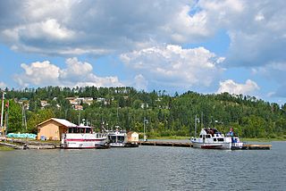
Gravel River Provincial Park covers 763 hectares (1,890 acres). The park is in the Thunder Bay District of Ontario, Canada, on Nipigon Bay, Lake Superior, at the mouth of the Gravel River. The park also includes the Little Gravel River and the Naomikan (Dead) River, which may be the course of the Gravel River before the railway line was built.

Lake Superior, the largest of the Great Lakes of North America, is also the world's largest freshwater lake by surface area, and the third largest freshwater lake by volume. The lake is shared by the Canadian province of Ontario to the north, the U.S. state of Minnesota to the west, and Wisconsin and the Upper Peninsula of Michigan to the south. The farthest north and west of the Great Lakes chain, Superior has the highest elevation of all five great lakes and drains into the St. Mary's River.
The Trans-Canada Highway (Highway 17) runs through the park from east to west. A power transmission line crosses the northern end of the park, and a snowmobile trail runs parallel to the power corridor. A Canadian Pacific railway line crosses the park from east to west. There was an MNR waste disposal site in the park, but it has been closed and moved to a new location. The park covers the east and center of Gravel Point, projecting into Lake Superior, but the western side of the point is a cottage subdivision that is not included in the park. The cottages are accessed by Mountain Bay Road, which runs south through the park from Highway 17.

The Trans-Canada Highway is a transcontinental federal-provincial highway system that travels through all ten provinces of Canada from the Pacific Ocean on the west to the Atlantic on the east. The main route spans 7,821 km (4,860 mi) across the country, one of the longest routes of its type in the world. The highway system is recognizable by its distinctive white-on-green maple leaf route markers, although there are small variations in the markers in some provinces.
Environment
The park is well-forested, and protects the land around the mouth of the slow-moving river, which meanders through the sands of its bird's foot deltaic fan. This is one of a small number of active deltas of this type in the Canadian Great Lakes. The park is in the boreal forest ecosystem. Controlled burning may be used as a substitute for natural forest fires, which are necessary for maintenance and renewal of the vegetation.
The peninsula is visited by many seasonally migrating waterfowl, and is used for nesting by shore birds. There is a nesting colony of great blue heron (Ardea herodias). Animal species include white-tailed deer (Odocoileus virginianus), moose (Alces alces), snowshoe hare (Lepus americanus) and Canada lynx (Lynx canadensis). Lake sturgeon (Acipenser fulvescens) are thought to spawn in the lower Gravel River, and northern brook lamprey (Ichthyomyzon fossor) have been found in the river.

The great blue heron is a large wading bird in the heron family Ardeidae, common near the shores of open water and in wetlands over most of North America and Central America, as well as the Caribbean and the Galápagos Islands. It is a rare vagrant to coastal Spain, the Azores, and areas of far southern Europe. An all-white population found only in south Florida and the Florida Keys is known as the great white heron. Debate exists about whether it is a white color morph of the great blue heron, a subspecies of it, or an entirely separate species.

The white-tailed deer, also known as the whitetail or Virginia deer, is a medium-sized deer native to North America, Central America, Ecuador, and South America as far south as Peru and Bolivia. It has also been introduced to New Zealand, Cuba, Jamaica, Hispaniola, the Bahamas, the Lesser Antilles, and some countries in Europe, such as the Czech Republic, Finland, Romania and Serbia. In the Americas, it is the most widely distributed wild ungulate.

The moose or elk (Eurasia), Alces alces, is a member of the New World deer subfamily and is the largest and heaviest extant species in the deer family. Moose are distinguished by the broad, palmate antlers of the males; other members of the deer family have antlers with a dendritic ("twig-like") configuration. Moose typically inhabit boreal forests and temperate broadleaf and mixed forests of the Northern Hemisphere in temperate to subarctic climates. Hunting and other human activities have caused a reduction in the size of the moose's range over time. Moose have been reintroduced to some of their former habitats. Currently, most moose are found in Canada, Alaska, New England, Fennoscandia, Baltic states, and Russia. Their diet consists of both terrestrial and aquatic vegetation. The most common moose predators are the gray wolf along with bears and humans. Unlike most other deer species, moose do not form herds and are solitary animals, aside from calves who remain with their mother until the cow begins estrus, at which point the cow chases away young bulls. Although generally slow-moving and sedentary, moose can become aggressive and move quickly if angered or startled. Their mating season in the autumn features energetic fights between males competing for a female.

Lake Superior Provincial Park is one of the largest provincial parks in Ontario, covering about 1,550 square kilometres (600 sq mi) along the northeastern shores of Lake Superior between Sault Ste. Marie and Wawa in Algoma District in Northeastern Ontario, Canada. Ontario Highway 17 now runs through the park. When the park was established by Ontario in 1944, there was no road access.
King's Highway 11, commonly referred to as Highway 11, is a provincially maintained highway in the Canadian province of Ontario. At 1,784.9 kilometres (1,109.1 mi), it is the second longest highway in the province, following Highway 17. Highway 11 begins at Highway 400 in Barrie, and arches through northern Ontario to the Ontario–Minnesota border at Rainy River via Thunder Bay; the road continues as Minnesota State Highway 72 across the Baudette-Rainy River International Bridge. North and west of North Bay, Highway 11 forms part of the Trans-Canada Highway. The highway is also part of MOM's Way between Thunder Bay and Rainy River.

Lake Nipigon is the largest lake entirely within the boundaries of the Canadian province of Ontario. It is part of the Great Lake drainage basin.

The Black Sturgeon River is a river in Thunder Bay District, Northwestern Ontario, Canada, located west of the Nipigon River, that flows to Lake Superior.
Nipigon is a township in Thunder Bay District, Northwestern Ontario, Canada, located along the west side of the Nipigon River and south of the small Lake Helen running between Lake Nipigon and Lake Superior. Lake Nipigon is located approximately 25 kilometres (16 mi) north of Nipigon.

The North Shore of Lake Superior runs from Duluth, Minnesota, United States, at the southwestern end of the lake, to Thunder Bay and Nipigon, Ontario, Canada, in the north to Sault Ste. Marie, Ontario, in the east. The shore is characterized by alternating rocky cliffs and cobblestone beaches, with forested hills and ridges through which scenic rivers and waterfalls descend as they flow to Lake Superior.

Whiteshell Provincial Park is a 2,721 km2 park centrally located in Canada in the province of Manitoba. It is found in the southeast region of the province along the Manitoba-Ontario boundary, approximately 130 km east of the city of Winnipeg. The park is located in the Canadian Shield region and has many rivers, remote lakes, boreal forest and bare granite ridges. It has rare archeological sites of petroforms on flat granite ridges. The park is used year-round for nature-oriented recreation activities.
The Nipigon River is a river in Thunder Bay District in Northwestern Ontario, Canada. It is about 48 km (30 mi) long and 50 to 200 m wide, and flows from Lake Nipigon to Nipigon Bay on Lake Superior at the community of Nipigon, dropping from an elevation of 260 to 183 m.
Tertiary Highway 811, commonly referred to as Highway 811, is the longest of Ontario's tertiary highways, and the highest posted route number in the province. The route encounters no named roads along its route, aside from its eastern terminus at Secondary Highway 527. It extends 59 kilometres (37 mi) westward into the wilderness, ending at a bridge over the Weaver River. The route was designated in 1976 with the intention of extending it further west, but this extension has yet to be constructed.
The Gull River is a river in Thunder Bay District in Northwestern Ontario, Canada. The river is in the Great Lakes Basin and is a tributary of Lake Nipigon. The river's name is translated from the Ojibwa name, gayaashk.
The Whitesand River is a river in Thunder Bay District, Ontario, Canada, part of the Hewitson River system. Another river in Thunder Bay District with the same name, Whitesand River, lies further northwest and flows into Lake Nipigon.
Whitesand Lake is a lake in Thunder Bay District, Ontario, Canada, part of the Hewitson River system. Another lake in Thunder Bay District with the same name, Whitesand Lake, lies further northwest and flows via the Whitesand River into Lake Nipigon.
The Mid-Continental Canadian forests are a taiga ecoregion of northern Canada.
The Midwestern Canadian Shield forests ecoregion, in the Taiga and Boreal forests Biome, are of northern Canada.

The Central Canadian Shield forests are a taiga ecoregion of Canada.

Black Bay Peninsula is a volcanic peninsula in Unorganized Thunder Bay District in Northwestern Ontario, Canada, located on the North Shore of Lake Superior. It separates Black Bay and Nipigon Bay and consists of over 300 flood basalt lava flows. Porphyry Island, an island entirely encompassed within Porphyry Island Provincial Park, lies off the tip of the peninsula. A 49-square-kilometre (19 sq mi) portion of the peninsula has been set aside as the Black Bay Peninsula Enhanced Management Area.

The Western Great Lakes forests is a terrestrial ecoregion as defined by the World Wildlife Fund. It is within the Temperate Broadleaf and Mixed Forests ecozone of North America, in the United States' states of Michigan, Wisconsin and Minnesota, and the Canadian provinces of Ontario and Manitoba.
Kelvin Island is a large island in the centre of Lake Nipigon, in Thunder Bay District in northwestern Ontario, Canada. It is named after the British scientist William Thomson, 1st Baron Kelvin (1824–1907).
The Namewaminikan River is a river in Thunder Bay District in northwestern Ontario, Canada. It is in the Great Lakes Basin and is a tributary of Lake Nipigon.


