
Algonquin Provincial Park is a provincial park located between Georgian Bay and the Ottawa River in Ontario, Canada, mostly within the Unorganized South Part of Nipissing District. Established in 1893, it is the oldest provincial park in Canada. Additions since its creation have increased the park to its current size of about 7,653 km2 (2,955 sq mi). The park is contiguous with several smaller, administratively separate provincial parks that protect important rivers in the area, resulting in a larger total protected area.

The Mattawa River is a river in central Ontario, Canada. It flows east from Trout Lake east of North Bay and enters the Ottawa River at the town of Mattawa. Counting from the head of Trout Lake, it is 76 km in length. The river's name comes from the Algonquin word for "meeting of waterways".

The Ogoki River is a river in the Thunder Bay and Cochrane Districts of Ontario. It springs from the wilderness just east of Savant Lake, flowing north of Lake Nipigon to Ogoki, where it joins the Albany River which empties into James Bay. The river is 480 kilometres (300 mi) long.

Mississagi Provincial Park is a natural environment-class park north of Elliot Lake, in Algoma District, Ontario, Canada. It lies on the Boland River, a tributary of the Little White River, which is a tributary of the Mississagi River. The park is accessed via Highway 639.

Garibaldi Provincial Park, also called Garibaldi Park, is a wilderness park located on the coastal mainland of British Columbia, Canada, 70 kilometres (43.5 mi) north of Vancouver. It was established in 1920 and named a Class A Provincial Park of British Columbia in 1927. The park is a popular destination for outdoor recreation, with over 30,000 overnight campers and over 106,000 day users in the 2017/2018 season.

Pukaskwa National Park is a national park located south of the town of Marathon, Ontario in the Thunder Bay District of northern Ontario, Canada. Established in 1978, Pukaskwa is known for its vistas of Lake Superior and boreal forests. The park covers an area of 1,878 square kilometres (725 sq mi), and protects part of the longest undeveloped shoreline anywhere on the Great Lakes.
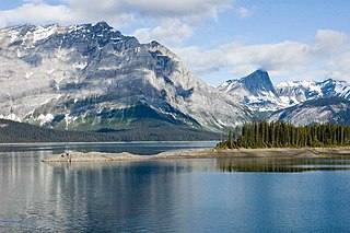
Peter Lougheed Provincial Park is a provincial park located in Alberta, Canada. The park is in Kananaskis Country about 90 kilometres (56 mi) west of Calgary, along the Kananaskis Trail.

Golden Ears Provincial Park is a Provincial park in British Columbia, Canada and is 555.9 square kilometres (214.6 sq mi). It is named after the prominent twin peaks which are commonly referred to as Golden Ears. The park's southern end is located on the northern edge of the district municipality of Maple Ridge on the north side of the Fraser River.
Itcha Ilgachuz Provincial Park is a provincial park in the Chilcotin Country of British Columbia, Canada. The park is 111,977 hectares in size and contains Far Mountain and Mount Downton, its two most prominent peaks.
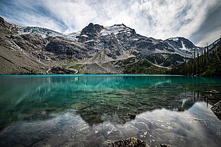
Joffre Lakes Provincial Park is a class A provincial park located 35 kilometres (22 mi) east of Pemberton in British Columbia, Canada. It was established in 1996, when Joffre Lakes Recreation Area was upgraded to park status.

Lady Evelyn-Smoothwater Provincial Park is a remote wilderness park in northeastern Ontario, Canada, north of Lake Temagami. It is one of five provincial parks located in the Temagami area.

The Queen Elizabeth II Wildlands Provincial Park is a provincial park in south-central Ontario, Canada, between Gravenhurst and Minden. The park, named for Elizabeth II, who at the time was Queen of Canada, is 33,505 hectares in size, making it the second largest park south of Algonquin Park, but it has a fragmented shape as a result of many private lands within its boundary.
Rock Lake Provincial Park is a provincial park in Alberta, Canada, located on the shores of Rock Lake, 64 km (40 mi) north-west from Hinton, north on the Bighorn Highway and 39 km west on an access road.

Buffalo Pound Provincial Park is a provincial park located in southern Saskatchewan, Canada, about 30 km (19 mi) north-east of downtown Moose Jaw and 86 km (53 mi) north-west of the city of Regina.

Canim Lake is a lake in British Columbia, Canada. Its west end is 36 km (22.4 mi) northeast of 100 Mile House. "Canim" means a type of large canoe in the Chinook Jargon. Canim Lake is 26.5 km (16.5 mi) long. It is also part of the territory of the Shuswap First Nation where the ancestors are part of the Lake Division of the Shuswap nation of the Interior Nations of British Columbia. The Reilly Commission states that the 2,029 hectares region around Canim Lake are set aside for the Shuswap First Nation. In the summer of 1995, there was an archaeological evidence of an ancient civilization and evidence of carbon dated as 4,300 old.

Murphys Point Provincial Park is a provincial park near Perth, Ontario, Canada. The 1,239-hectare (3,060-acre) park features natural areas prepared for hiking and skiing as well as access for day-use camping and water sports at Big Rideau Lake. Facilities include a park store, visitor centre and several "comfort centres", with flush toilets, showers and laundry facilities for the multi-day camper.
Narrow Hills Provincial Park is a northern boreal forest provincial recreational park in the Canadian province of Saskatchewan. It is located in a hilly plateau called the Cub Hills and contains several recreational facilities and over 25 accessible lakes within its boundaries. The geographical features of the park, including the lakes, valleys, and lowlands were formed over 10,000 years ago during the last ice age. The town of Smeaton is the closest community and it is located 70 kilometres (43 mi) to the south.

Trout Lake, formerly known as Fish Lake and Soda Butte Lake, is a 12 acres (0.049 km2) popular backcountry lake for hikers and anglers in Yellowstone National Park. The lake is located approximately .33 miles (0.53 km) north of the Northeast Entrance Road near the confluence of Pebble Creek and Soda Butte Creek. The lake sits in a depression on a high bench above the Soda Butte Creek Canyon. A steep trail through a Douglas fir forest leads to the lake. The trailhead is located at: 44°53′57″N110°7′21″W.

Mount Seymour Provincial Park is a park in Vancouver, British Columbia's North Shore Mountains. With an area of 35 square kilometres, it is located approximately 15 kilometres north of Downtown Vancouver. The park, named after Frederick Seymour, was established in 1936. Mount Seymour Provincial Park provides visitors with a variety of recreational activities and animals with natural habitat.

Silver Lake is a lake in Tay Valley, Lanark County, and Central Frontenac, Frontenac County, in Eastern Ontario, Canada. It is the source of Silver Lake Creek and is in the Ottawa River drainage basin.


