Dundas Valley Conservation Area

Last updated
Dundas Valley Conservation Area
DundasValleyPark.jpg
Entrance to the Conservation Area in October 2020
Location Canada
Nearest city Hamilton, Ontario
Coordinates 43°14′15″N79°59′38″W / 43.23750°N 79.99389°W / 43.23750; -79.99389
Area1200 ha
Established1970
Governing body Hamilton Conservation Authority
Website https://conservationhamilton.ca/conservation-areas/dundas-valley/

Dundas Valley Conservation Area is located on the Niagara Escarpment in Dundas, Ontario, a constituent community of Hamilton, Ontario, and is owned and operated by the Hamilton Conservation Authority. Its 40-kilometre trail system provides a connection to the Bruce Trail. [1] The area contains a trailhead of the Hamilton-Brantford-Cambridge Trails, Canada's first fully developed interurban multi-use trail system, which is a part of the Trans Canada Trail. [2]

Contents

Landform

The origins of the Dundas Valley, the main feature of the area, date back to the pre-glacial times, when the Niagara Escarpment was deeply incised by erosion. [3] The Wisconsin Glaciation furthered the erosion processes and resulted in deposition of glacial and glaciolacustrine sediments, forming the hummocky kame and kettle topography of the present. [4] In post-glacial times, the land has been shaped by the various streams that run through Dundas Valley. The area is contained in the Carolinian forest area of Eastern North America. [5] It contains 585 species of plants and animals, including 55 endangered species. [6]

Trail system

The Dundas Valley 40-kilometre long trail system is a recreational network of hiking, cycling and equestrian trails. It contains trails that form a loop, as well as out-and-back trails that have different start and finish terminals. While the majority of trails are contained in the area of Dundas, Ontario, there are some that extend Southwest into the neighboring community of Ancaster, Ontario. [6]

Main Loop Trail

The Main Loop Trail connects directly to the Trail Centre. It is an approximately 3,420m loop located in the heart of Dundas Valley that also serves as a connection to other trails. The Main Loop Trail is also part of the Bruce Trail. The trail passes by The Hermitage (Hamilton, Ontario) as well as the Hermitage Parking Lot and the Merrick Parking Lot. [6]

Headwaters Trail

Approximately one kilometer from the Trail Centre, the Headwaters Trail begins from an entrance on the Main Loop Trail. The 10.5-kilometre trail loop is the longest in Dundas Valley and consists of rolling hills, forests and meadows. Initially the trail passes by the Griffin House and crosses Sulphur Springs Road in Dundas, Ontario. The trail continues South and crosses Martin Road in Ancaster, Ontario, where it continues for approximately 1400 meters before forming a 3,240m loop just East of Paddy Greene Road in Ancaster. Headwaters Trail is also the entrance to the following trails: Homestead Trail, Lookout Trail, G. Donald Trail, and Spring Valley Trail. [6]

Sawmill Trail

Directly North of the Trail Centre is the Sawmill Trail. It is a 2.6 kilometer long loop that passes by Sawmill Pond and connects to the McCormack, Beckett, John White and Spring Creek Trails. [6] Along the Sawmill Trail is the John A. Beckett Living Forest. Named after a local judge and Hamilton Conservation Authority founder, [7] the forest contains trees native to the area that have been dedicated in honour of a person of the donor's choosing. [8]

Cultural heritage

Trail Centre

The Trail Centre. Trail Centre - Dundas Valley Conservation Area.jpg
The Trail Centre.

A modern replica of a Victorian railway station serves as the area's Trail Centre. Adjacent to it is a remnant of the Toronto, Hamilton and Buffalo Railway track, with a 1929 executive coach car and a 1931 baggage car donated by the Canadian Pacific Railway. The track was converted into an interurban rail trail, having been abandoned in 1988. This rail trail now serves as part of the Hamilton to Brantford Rail Trail, a 32-kilometre trail with terminals in West Hamilton and East Brantford. [9]

The Giant Rib Discovery Centre is located in the Trail Centre. Open on weekendsOpen seven days a week in July and August, and on weekends September to June, [10] the Centre features natural history displays and education programs about the Niagara Valley Escarpment.

The Hermitage

A magnificent stone mansion was built in 1855 by George Gordon Browne Leith, an immigrant from Scotland. Construction materials were obtained locally. Bricks originated from the Dundas Valley clay; limestone was quarried at the Credit River valley. Numerous attendant buildings were built, including a carriage house, children's nursery and a stable. After the death of Mrs. Leith in 1900, Mrs. Alma Dick Lauder, Leith's daughter and writer for the Hamilton Spectator, lived in The Hermitage. In October 1934, The Hermitage was almost completely burned. [11] The Hermitage burned down in 1934. After that, Leith's daughter Mrs. Lauder then built a much smaller house among the ruins and lived there until her death in 1942. [12] To prevent further deterioration, the ruins were stabilized using wooden braces.

Sulphur Springs Hotel

In 1865, George Leith sold ten acres of land to Mr. & Mrs. Matthew Wright on the north side of present-day Sulphur Springs Road. In 1870 they sold the property, and in 1880 the eighteen-bedroom home was turned into a hotel. A sulphurous mineral spring is found in the area. was the site of the Sulphur Springs Hotel built during the late 1880s.Since sulphur was believed to possess wondrous curative powers curative properties by local settlers and Indigenous people, the hotel's mineral spa was a very popular summertime destination. [11] The hotel closed down in 1910 after it was ravaged by two fires. The spring flows from a fountain first built in 1820 from cast iron. In 1850, it was replaced by a cement fountain. Having crumbled, it was restored in 1972.

Griffin House

The Griffin House was purchased in 1834 by Enerals Griffin and his wife Priscilla, including fifty acres of land. Born a slave in Virginia, Enerals escaped to Canada sometime in 1828-29, and both he and his descendants farmed in the area for the next 150 years. [13] The house is 1.5 storeys and consists of a dining room, living room and two upstairs bedrooms. The house was sold to the Hamilton Region Conservation Authority in 1988, with much of the original siding and clapboard preserved due to it being covered with board and batten cladding. [14]

Today, the Griffin House can be seen off of the Headwaters Trail, on Mineral Springs Road in Ancaster. [6]

Events

The OFSAA Cross Country Championships in 1994 saw competitors run through portions of the Headwaters Trail in Ancaster, off of Martin Road. [15]

Since 1992, Dundas Valley has also been the venue for the Sulphur Springs Trail Race, a series of running races of various distances that utilize different trail loops in Dundas Valley. [16]

The Hamilton Conservation Authority Equestrian Campout was first hosted in 2005, which is a weekend-long event where participants camp in the conservation area with their horses. [17]

Related Research Articles

<span class="mw-page-title-main">Bruce Trail</span> Hiking trail in Ontario, Canada

The Bruce Trail is a hiking trail in southern Ontario, Canada, from the Niagara River to the tip of Tobermory, Ontario. The main trail is more than 890 km (550 mi) long and there are over 400 km (250 mi) of associated side trails. The trail mostly follows the edge of the Niagara Escarpment, one of the nineteen UNESCO World Biosphere Reserves in Canada. The land the trail traverses is owned by the Government of Ontario, local municipalities, local conservation authorities, private landowners, and the Bruce Trail Conservancy (BTC). The Bruce Trail is the oldest and longest marked hiking trail in Canada. Its name is linked to the Bruce Peninsula and Bruce County, through which the trail runs. The trail is named after the county, which was named after James Bruce, 8th Earl of Elgin who was Governor General of the Province of Canada from 1847 to 1854.

<span class="mw-page-title-main">Brantford</span> City in Ontario, Canada

Brantford is a city in Ontario, Canada, founded on the Grand River in Southwestern Ontario. It is surrounded by Brant County, but is politically separate with a municipal government of its own that is fully independent of the county's municipal government.

<span class="mw-page-title-main">Ancaster, Ontario</span> Community/former town in Ontario, Canada

Ancaster is a historic town in the city of Hamilton, Ontario, Canada, located on the Niagara Escarpment. Founded as a town in 1793, it immediately developed itself into one of the first significant and influential early British Upper Canada communities established during the late 18th century eventually amalgamating with the city of Hamilton in 2001. By 1823, due to its accessible waterpower and location at the juncture of prehistoric indigenous trading routes, Ancaster had become Upper Canada's largest industrial and commercial centre. Additionally, Ancaster had at that time attracted the 2nd largest populace (1,681) in Upper Canada, trailing only Kingston, but surpassing the populations of nearby Toronto (1,376) and Hamilton (1,000). After this initial period of prosperity in the late 18th century, sudden significant water and rail transportation advancements of the early 19th century would soon better benefit Ancaster's neighbouring towns nearer the Lake Ontario waterfront. Stationary steam engines for industries rapidly developing in the 19th century would eventually make Ancaster's water-powered industries less vital. As a result, after the 1820s, Ancaster's influence during the remainder of the 19th century would begin to wane.

<span class="mw-page-title-main">Flamborough, Ontario</span> Former municipality, now part of Hamilton, Ontario, Canada

Flamborough is a district and former municipality in the city of Hamilton, Ontario, Canada. For most of its existence before amalgamation with Hamilton in 2001, Flamborough comprised the former townships of East Flamborough, West Flamborough, and Beverly, as well as the village of Waterdown. The largest suburban community is the former village of Waterdown containing perhaps one third of its thirty thousand or so inhabitants. Other Flamborough communities include Carlisle, Christie's Corners, Clappison's Corners, Copetown, Freelton, Greensville, Lynden, Kirkwall, Millgrove, Mountsberg, Orkney, Peters Corners, Rockton, Troy, Sheffield, Valens, Strabane and Westover.

King's Highway 403, or simply Highway 403, is a 400-series highway in the Canadian province of Ontario that travels between Woodstock and Mississauga, branching off from and reuniting with Highway 401 at both ends and travelling south of it through Hamilton and Mississauga. It is concurrent with the Queen Elizabeth Way (QEW) for 22 km (14 mi) from Burlington to Oakville. The Highway 403 designation was first applied in 1963 to a short stub of freeway branching off the QEW, and the entire route was completed on August 15, 1997, when the section from Brantford to the then-still independent Town of Ancaster was opened to traffic. The section of Highway 403 between Woodstock and Burlington was formally dedicated as the Alexander Graham Bell Parkway on April 27, 2016, in honour of Alexander Graham Bell.

Royal Botanical Gardens (RBG) is headquartered in Burlington owning extensive environmental protection areas, historic sites and culturally relevant gardens in Hamilton, Ontario, Canada. It is one of the major tourist attractions between Niagara Falls and Toronto, as well as a significant local and regional horticultural, education, conservation, and scientific resource. The mandate is derived by a Provincial Act of 1941 centred on human interaction with the natural world and protection of environmentally significant lands that form the western tip of Lake Ontario. Royal Botanical Gardens spans an area of about 10 km by 4 km, dominated by two coastal wetlands, and glacial-carved landscapes that extend from the lake up to the Niagara Escarpment plateau. The various gardens and natural areas are accessed through nine public entrance locations. It is one of several Prescribed Public Bodies listed under the Ontario Heritage Act.

<span class="mw-page-title-main">Russ Powers</span> Canadian politician

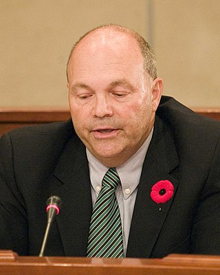
Russ Powers is a Canadian politician. He was a member of the House of Commons in Canada's 38th Parliament, representing the riding of Ancaster—Dundas—Flamborough—Westdale for the Liberal Party from 2004 to 2006.

<span class="mw-page-title-main">Sixteen Mile Creek (Halton Region)</span> River in Ontario, Canada

Sixteen Mile Creek is a river in Halton Region in the Greater Toronto Area of Ontario, Canada. It is in the Great Lakes Basin, and flows from the Niagara Escarpment through the towns of Milton and Oakville to Lake Ontario.

<span class="mw-page-title-main">The Hermitage (Hamilton, Ontario)</span> Historic house museum in Ontario, Canada

The Hermitage was a large residence situated in Ancaster, Hamilton, Ontario, Canada, which now exists as ruins and is part of The Hermitage and Gatehouse Museum maintained by the Hamilton Conservation Authority. The location is a popular destination for hikers and people interested in the paranormal.

<span class="mw-page-title-main">Hamilton Conservation Authority</span>

The Hamilton Conservation Authority maintains the greenspace, trails, parks and some attractions in the Hamilton, Ontario, Canada.

<span class="mw-page-title-main">Geography of Hamilton, Ontario</span>

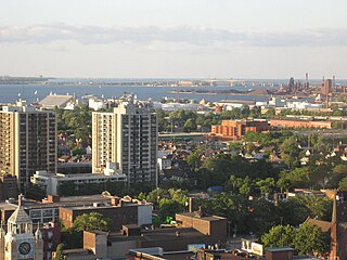
Hamilton is located on the western end of the Niagara Peninsula and wraps around the westernmost part of the Lake Ontario. Most of the city including the downtown section lies along the south shore. Situated in the geographic centre of the Golden Horseshoe, it lies roughly midway between Toronto and Buffalo. The two major physical features are Hamilton Harbour marking the northern limit of the city and the Niagara Escarpment running through the middle of the city across its entire breadth, bisecting the city into 'upper' and 'lower' parts.

<span class="mw-page-title-main">Brantford and Hamilton Electric Railway</span>

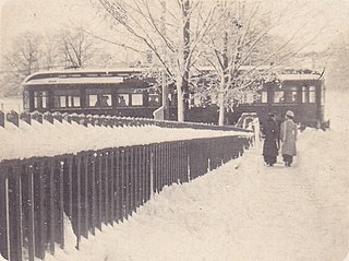
The Brantford and Hamilton Electric Railway (B&H) was an interurban electric railway which operated between Hamilton and Brantford in Ontario, Canada. According to Hilton & Due, this was the last radial (interurban) railway constructed in the Hamilton area and the only one built to a high standard.

The Hamilton–Brantford–Cambridge Trails are a network of multiuse interurban recreational rail trails connecting several municipalities in southern Ontario, Canada. The trails are part of the Southern Ontario Loop of the Trans Canada Trail. From end to end, the trail is 80 kilometres (50 mi) long, running from Cambridge south through Paris to Brantford and then East to central Hamilton.

Cainsville is a community straddling the boundary of Brantford and Brant County in Ontario, Canada.

<span class="mw-page-title-main">Darnley Cascade</span> Waterfall in Hamilton, Ontario

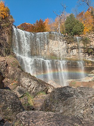
Darnley Cascade is a 4-metre-high (13 ft) cascade waterfall located at Crooks Hollow Conservation Area in Greensville, Hamilton, Ontario, Canada. Nearby attractions include Bruce Trail, Dundas Valley Conservation Area, Spencer Gorge/Webster's Falls Conservation Area, Hermitage ruins, Royal Botanical Gardens, Dundurn Castle, Christie Lake Conservation Area, Dundas Historical Society Museum and Carnegie Gallery.

<span class="mw-page-title-main">Griffin House (Ancaster, Ontario)</span>

Griffin House is a house built in 1827 by Englishmen in Ancaster. It was purchased, along with 50 acres of farmland, by Enerals Griffin and his wife Priscilla in 1834. The Griffins were enslaved in their early lives, but self-liberated by escaping to Canada in the early 1800s. The Griffins were some of the first Black Settlers in the area, and the site remains an important part of Black history in Canada. . It offers Underground Railroad tours and history-related programs.

Ainslie Wood is a residential neighbourhood in Hamilton, Ontario, Canada. It is centered on Alexander Park and located near McMaster University. It is bordered to the north by Main Street, Cootes Drive and Dundas, to the south and east by Highway 403, and to the west by Dundas and Ancaster.

<span class="mw-page-title-main">Lake Erie and Northern Railway</span> Former interurban railway in Ontario, Canada

The Lake Erie and Northern Railway was an interurban electric railway which operated in the Grand River Valley in Ontario, Canada. The railway owned and operated a north–south mainline which ran from Galt in the north to Port Dover on the shore of Lake Erie in the south. Along the way, it ran through rural areas of Waterloo County, Brant County, and Norfolk County, as well as the city of Brantford, where it had an interchange with the Brantford and Hamilton Electric Railway. Construction on the mainline began in 1913. The railway began operations in 1916 as a subsidiary of the Canadian Pacific Railway (CPR), which had purchased the line before construction had finished. In 1931, it was consolidated with the Grand River Railway under a single CPR subsidiary, the Canadian Pacific Electric Lines (CPEL), which managed both interurban railways, though they continued to exist as legally separate entities. Passenger service was discontinued in 1955 but electric freight operations continued until 1961, when the LE&N's electric locomotives were replaced by diesel CPR locomotives and the line was de-electrified. In the same year, service on the mainline from Simcoe to Port Dover was discontinued, but the remainder continued to operate as a branchline which as early as 1975 was known as the CP Simcoe Subdivision. The remainder of the line was officially abandoned in the early 1990s, ending almost seventy-five years of operation.

<span class="mw-page-title-main">Tinawatawa</span> Former Iroquois village

Tinawatawa, also called Quinaouatoua, was an Iroquois village of the Seneca people on the western end of the Niagara corridor, described as "a fertile flat belt of land stretching from western New York to the head waters of the Thames River". It was located on the western end of Lake Ontario.

References

  1. "Dundas Valley Conservation Area Brochure" (PDF). Hamilton Conservation Authority. Archived from the original (PDF) on April 12, 2007. Retrieved 2008-08-10.
  2. "Rail Trail Link Brochure" (PDF). Hamilton Conservation Authority. Archived from the original (PDF) on 2007-09-27. Retrieved 2008-08-10.
  3. "Dundas Valley". Carolinian Canada. Archived from the original on 2008-06-22. Retrieved 2008-08-10.
  4. "Natural Areas Report: DUNDAS VALLEY FORESTS". Ontario Ministry of Natural Resources. 2008-06-27. Retrieved 2008-08-10.[ dead link ]
  5. "Our Impact". Carolinian Canada. Retrieved 2020-11-17.
  6. 1 2 3 4 5 6 "Dundas Valley Brochure 2020" (PDF). Conservation Hamilton. Retrieved 2020-11-17.
  7. "Thomas A. Beckett". Hamilton Public Library. Retrieved 2020-11-17.
  8. "Beckett Forest tree dedication fact sheet" (PDF). Hamilton Conservation Foundation. 2017-09-01. Retrieved 2020-11-17.
  9. "Brantford to Hamilton Rail Trail". Grand River Conservation Authority. Retrieved 2020-11-29.
  10. "Dundas Valley Conservation Area". Hamilton Conservation Authority. Retrieved 2020-11-17.
  11. 1 2 "Hermitage Gatehouse". Hamilton Conservation Authority. Retrieved 2020-11-29.
  12. "Dundas Valley Conservation Area - Main loop Trail Guide" (PDF). Hamilton Conservation Authority. Archived from the original (PDF) on October 6, 2014. Retrieved 2008-08-10.
  13. "Main Loop Trail Guide 2005" (PDF). Conservation Hamilton. Retrieved 2020-11-17.
  14. "Griffin House National Historic Site". City of Hamilton. 2020-11-16. Retrieved 2020-11-17.
  15. "Cross Country Running: Past Results". Ontario Federation of School Athletic Associations. Retrieved 2020-11-17.
  16. "Sulphur Springs Trail Races". Burlington Runners. Retrieved 2020-11-17.
  17. "2019 Equestrian Campout Fundraiser". Hamilton Conservation Foundation. 2019-08-12. Retrieved 2020-11-17.