The protected areas of South Africa include national parks and marine protected areas managed by the national government, public nature reserves managed by provincial and local governments, and private nature reserves managed by private landowners. Most protected areas are intended for the conservation of flora and fauna. National parks are maintained by South African National Parks (SANParks). A number of national parks have been incorporated in transfrontier conservation areas.
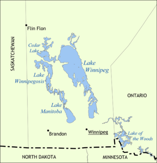
Lake Winnipeg is a very large, but relatively shallow 24,514-square-kilometre (9,465 sq mi) lake in North America, in the province of Manitoba, Canada. Its southern end is about 55 kilometres (34 mi) north of the city of Winnipeg. It is the largest lake within southern Canada's borders, and is part of the most undeveloped large watershed of southern Canada.
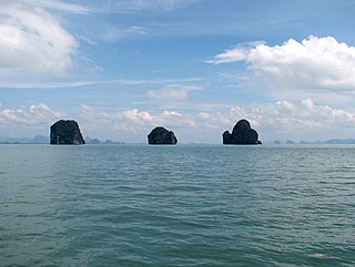
Phang Nga is one of the southern provinces (changwat) of Thailand, on the shore of the Andaman Sea to the west and Phang Nga Bay to the south. Neighboring provinces are Ranong, Surat Thani, and Krabi. To the south is the Phuket Province, connected by the Sarasin Bridge.

Whitefish Bay is a large bay on the eastern end of Lake Superior between Michigan, United States, and Ontario, Canada. It is located between Whitefish Point in Michigan and Whiskey Point along the more rugged, largely wilderness Canadian Shield of Ontario. The international border runs through the bay, which is heavily used by shipping traffic northbound from and southbound to the Soo Locks.

Sandy Hook is a barrier spit in Middletown Township, Monmouth County, New Jersey, United States. The barrier spit, approximately 6 miles (9.7 km) in length and varying from 0.1 to 1.0 mile wide, is located at the north end of the Jersey Shore. It encloses the southern entrance of Lower New York Bay south of New York City, protecting it from the open waters of the Atlantic Ocean to the east. The Dutch called the area "Sant Hoek", with the English "Hook" deriving from the Dutch "Hoek", meaning "spit of land".

Killbear Provincial Park is a provincial park located on Georgian Bay in the Parry Sound District of Ontario, near the town of Nobel. Killbear combines sandy beaches typical of the Great Lakes with the rock ridges and pines of the Canadian Shield.

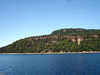
Quadra Island is an island off the eastern coast of Vancouver Island, British Columbia, Canada, part of the Discovery Islands located within the Strathcona Regional District. Quadra Island is about 35 kilometres from its northernmost point to its southernmost point. The island at its narrowest point, on its southern peninsula, is less than 2 km (1.24 mi) wide, and at its widest point, about 15 km (9 mi) wide. Quadra island is about 310 square kilometres in area. The population of island and surrounding mainland inlets, as of the 2006 federal census, was 2,472, down from the 2001 federal census count of 2,548. In 1903 it was named after the Spanish navigator Juan Francisco de la Bodega y Quadra, who explored and settled the Vancouver Island area in the late 18th century. It is separated from Vancouver Island by Discovery Passage, and from Cortes Island, and is linked to that island by a ferry from Heriot Bay on its eastern shore. The island has many beaches, trails, lakes, and parks. Main Lake Provincial Park is located on the northern part of the island, and Rebecca Spit Marine Provincial Park is on the eastern shore, near Heriot Bay.

Lemon Creek is a stream located on the South Shore of Staten Island, one of the five boroughs of New York City. It is one of the few remaining ground-level creeks in New York City.

The District Municipality of Sechelt is located on the lower Sunshine Coast of British Columbia. Approximately 50 km northwest of Vancouver, it is accessible from mainland British Columbia by a 40-minute ferry trip between Horseshoe Bay and Langdale, and a 25-minute drive from Langdale along Highway 101, also known as the Sunshine Coast Highway. The name Sechelt is derived from the Sechelt language word, shishalh, the name of the First Nations people who first settled the area thousands of years ago.
Hornby Island of British Columbia, Canada, is a Salish Sea island located near Vancouver Island's Comox Valley.

Howe Sound is a roughly triangular sound, or more precisely a network of fjords situated immediately northwest of Vancouver.
Anderson Bay Provincial Park is a provincial park in British Columbia, Canada, located on the southeast end of Texada Island near the community of Gillies Bay. Created in 2000, it is approximately 35 ha. in area.
Sandy Island Marine Provincial Park, formerly Sandy Island Provincial Park and also known as Tree Island Park, is an 18 hectare provincial park in British Columbia, Canada, located off the north end of Denman Island, on the west side of the Strait of Georgia to the south of Comox. The park comprises Sandy Island and the Seal Islets. It is accessible by boat and, at low tide, by foot across tidal flats from Longbeak Point on Denman Island.

Tweedsmuir North Provincial Park and Protected Area is a provincial park in British Columbia, Canada, which along with Tweedsmuir South Provincial Park and Entiako Provincial Park and Protected Area were once part of Tweedsmuir Provincial Park, then B. C.'s largest park, 9,810 square kilometres (3,790 sq mi) located in the Coast Range. Tweedsmuir gained park status in 1938 and Wells Gray Provincial Park in 1939, the earliest large parks established in the provincial parks system. Tweedsmuir North Provincial Park and Protected Area was re-designated a park and protected area as the latter classification allows resource extraction and other economic activities not permitted in full park designations. Entiako Provincial Park and Protected Area is located on the south flank of the Nechako River watercourse.

Tribune Bay Provincial Park is a provincial park located on Hornby Island in British Columbia, Canada. It features a broad, crescent-shaped beach of white sand, Tribune Bay, and spring wildflowers. There are opportunities for canoeing, fishing, hiking, tennis, picnicking, and open water swimming. Six pit toilets are provided.
The Fundy Shore Ecotour is a scenic drive in the Canadian province of Nova Scotia and encircles several sub-basins of the Bay of Fundy, which contains the highest tidal range on the planet.

The Western Port Bay Trail is a shared use path for cyclists and pedestrians which follows the coastline of Western Port Bay through several towns on the eastern side of the Mornington Peninsula in Melbourne, Victoria, Australia. The trail begins in Somerville, travelling south through the towns of Tyabb, Hastings, Bittern, Somers and ending in the town of Balnarring. Construction of the trail began in 1994, initially only as a 9 km path connecting the towns of Somerville, Tyabb and Hastings.

The Otis Pike Fire Island High Dune Wilderness, also known as the Otis G. Pike Wilderness Area or the Fire Island Wilderness, is a federally protected wilderness area located on Fire Island, a barrier island off the south shore of Long Island, New York, United States. The 1,380-acre wilderness is contained within the larger Fire Island National Seashore.

Wide Bay–Burnett is a region of the Australian state of Queensland, located between 170 and 400 kilometres north of the state capital, Brisbane. The area's population growth has exceeded the state average over the past 20 years, and it is forecast to grow to more than 430,000 by 2031. It is the subject of the Draft Wide Bay–Burnett Regional Plan, which aims to facilitate this growth while protecting over 90% of the region from urban development.


