List of historic places outside Greater Sudbury
Algoma District
| Name | Address | Coordinates | Government recognition (CRHP №) | | Image |
|---|---|---|---|---|---|
| Light Tower | Caribou Island Caribou Island ON | 47°20′23″N85°49′34″W / 47.3398°N 85.8260°W | Federal (10361) |  | |
| Former Canadian National Railways Station | West End Road (at 2nd Ave.) Hornepayne ON | 49°13′12″N84°46′34″W / 49.22°N 84.776°W | Federal (4588) |  More images | |
| Fort St. Joseph National Historic Site of Canada | St. Joseph Island Jocelyn ON | 46°05′05″N83°53′45″W / 46.0847°N 83.8957°W | Federal (12976) |  More images | |
| Light Tower | Michipicoten Island Michipicoten ON | 47°45′14″N85°35′48″W / 47.7538°N 85.5968°W | Federal (10365) |  Upload Photo | |
| Rydal Bank Church | 1634 Highway 638 Plummer Additional ON | 46°17′55″N83°47′37″W / 46.2985°N 83.7937°W | Plummer Additional municipality (8177) | Upload Photo | |
| Rydal Bank Community Hall | 16 Hoath Street Plummer Additional ON | 46°17′55″N83°47′37″W / 46.2985°N 83.7937°W | Plummer Additional municipality (8176) | Upload Photo | |
| 34-36 Herrick Street | 34 Herrick Street Sault Ste. Marie ON | 46°30′28″N84°19′22″W / 46.5077°N 84.3228°W | Sault Ste. Marie municipality (7374) | 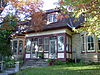 More images | |
| 115 Upton | 115 Upton Road Sault Ste. Marie ON | 46°30′21″N84°18′50″W / 46.5059°N 84.3138°W | Sault Ste. Marie municipality (7348) | Upload Photo | |
| 143 McGregor Avenue | 143 McGregor Avenue Sault Ste. Marie ON | 46°30′22″N84°18′41″W / 46.506°N 84.3114°W | Sault Ste. Marie municipality (6141) |  More images | |
| Algoma Central Engine House | Highway 532 Unorganized North Algoma District (Searchmont) ON | 46°46′59″N84°03′14″W / 46.783°N 84.054°W | Federal (4614,(7532) |  More images | |
| Algonquin Hotel | 864 Queen Street East Sault Ste. Marie ON | 46°30′23″N84°19′23″W / 46.5064°N 84.323°W | Sault Ste. Marie municipality (3572) | 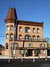 More images | |
| Barnes-Fawcett Block | 358 Queen Street Sault Ste. Marie ON | 46°30′46″N84°20′03″W / 46.5127°N 84.3343°W | Sault Ste. Marie municipality (7375) | 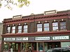 More images | |
| Bishop Fauquier Memorial Chapel | 1540 Queen Street East Sault Ste. Marie ON | 46°30′00″N84°17′14″W / 46.4999°N 84.2873°W | Sault Ste. Marie municipality (3313) | 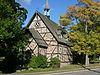 More images | |
| Bishop Fauquier Memorial Chapel Cemetery | 1540 Queen Street East Sault Ste. Marie ON | 46°30′00″N84°17′12″W / 46.4999°N 84.2867°W | Sault Ste. Marie municipality (3574) |  More images | |
| Buchan House | 943 Landslide Road Sault Ste. Marie ON | 46°35′36″N84°16′48″W / 46.5934°N 84.2801°W | Sault Ste. Marie municipality (5600) |  More images | |
| Central United Church | 160 Spring Street Sault Ste. Marie ON | 46°30′40″N84°19′46″W / 46.5111°N 84.3295°W | Ontario (5601), Sault Ste. Marie municipality (4222) | 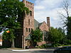 More images | |
| Clergue Blockhouse | 831 Queen Street East Sault Ste. Marie ON | 46°30′23″N84°19′29″W / 46.5063°N 84.3246°W | Sault Ste. Marie municipality (5595) | 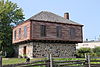 More images | |
| Coronation Block | 234 Queen Street East Sault Ste. Marie ON | 46°30′53″N84°20′12″W / 46.5147°N 84.3367°W | Sault Ste. Marie municipality (7356) |  More images | |
| Dawson Block | 708 Queen Street East Sault Ste. Marie ON | 46°30′28″N84°19′39″W / 46.5077°N 84.3274°W | Sault Ste. Marie municipality (8329) | 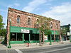 More images | |
| Eastbourne | 1048 Queen Street East Sault Ste. Marie ON | 46°30′20″N84°18′50″W / 46.5056°N 84.314°W | Sault Ste. Marie municipality (4056) |  More images | |
| Ermatinger House National Historic Site of Canada | 831 Queen Street East Sault Ste. Marie ON | 46°30′23″N84°19′26″W / 46.5064°N 84.3239°W | Federal (7415), Sault Ste. Marie municipality (5602) |  More images | |
| Forest Insect Laboratory | 875 Queen Street East Sault Ste. Marie ON | 46°30′20″N84°19′21″W / 46.5056°N 84.3224°W | Sault Ste. Marie municipality (5528) |  More images | |
| Hussey Block | 246 Queen Street East Sault Ste. Marie ON | 46°30′53″N84°20′12″W / 46.5147°N 84.3367°W | Sault Ste. Marie municipality (7685) | 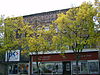 More images | |
| North West Company Lock | 75 Huron Street Sault Ste. Marie ON | 46°30′54″N84°19′21″W / 46.515°N 84.3226°W | Sault Ste. Marie municipality (5529) | 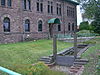 More images | |
| Old Post Office (Sault Ste. Marie Museum) | 690 Queen Street East Sault Ste. Marie ON | 46°30′29″N84°19′40″W / 46.508°N 84.3278°W | Sault Ste. Marie municipality (5519) | 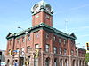 More images | |
| Old Town Cemetery | 1186 Queen Street East Sault Ste. Marie ON | 46°30′18″N84°18′21″W / 46.5051°N 84.3057°W | Sault Ste. Marie municipality (5550) |  More images | |
| Ontario Provincial Air Service Hangars | 69 Church Street Sault Ste. Marie ON | 46°30′17″N84°19′26″W / 46.5047°N 84.3238°W | Sault Ste. Marie municipality (5530) |  More images | |
| Precious Blood Cathedral | 778 Queen Street East Sault Ste. Marie ON | 46°30′27″N84°19′33″W / 46.5075°N 84.3259°W | Ontario (8185), Sault Ste. Marie municipality (5604) |  More images | |
| Rotary Welcome Cairns | Russ Ramsay Way Sault Ste. Marie ON | 46°30′29″N84°19′54″W / 46.5081°N 84.3318°W | Sault Ste. Marie municipality (7768) |  More images | |
| Sault Ste. Marie Canal National Historic Site of Canada | 1 Canal Drive Sault Ste. Marie ON | 46°30′44″N84°21′16″W / 46.5121°N 84.3545°W | Federal (4431) |  More images | |
| Sault Ste. Marie Canal Office Building | 1 Canal Drive Sault Ste. Marie ON | 46°30′42″N84°21′26″W / 46.5116°N 84.3571°W | Federal (11363) | 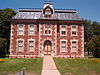 More images | |
| Sault Ste. Marie Canal Power House | 1 Canal Drive Sault Ste. Marie ON | 46°30′48″N84°20′59″W / 46.5134°N 84.3498°W | Federal (16389) |  More images | |
| Sault Ste. Marie Canal Superintendent's House | 1 Canal Drive Sault Ste. Marie ON | 46°30′50″N84°21′19″W / 46.5139°N 84.3552°W | Federal (11300) | 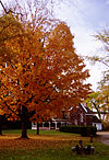 More images | |
| Sault Ste. Marie Canal Workshop | 1 Canal Drive Sault Ste. Marie ON | 46°30′48″N84°20′59″W / 46.5134°N 84.3498°W | Federal (11320) | 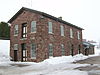 More images | |
| Sault Ste. Marie Cenotaph | 426 Queen Street East Sault Ste. Marie ON | 46°30′42″N84°19′58″W / 46.5118°N 84.3328°W | Sault Ste. Marie municipality (8437) | 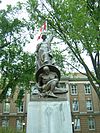 More images | |
| Sault Ste. Marie District Courthouse | 420 Queen Street East Sault Ste. Marie ON | 46°30′43″N84°19′57″W / 46.512°N 84.3324°W | Sault Ste. Marie municipality (5611) | 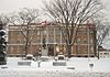 More images | |
| Tower | Southern tip of Ile Parisienne, northwest of Sault Ste. Marie in Lake Superior Sault Ste. Marie ON | 46°38′43″N84°43′26″W / 46.6453°N 84.7238°W | Federal (11494) | Upload Photo | |
| Upton | 10 Kensington Terrace Sault Ste. Marie ON | 46°30′22″N84°18′43″W / 46.5062°N 84.3119°W | Sault Ste. Marie municipality (7767) |  More images | |
| Lighttower | Northern tip of Shoal Island, in the St. Mary River St. Joseph ON | 46°18′48″N84°04′33″W / 46.3133°N 84.0757°W | Federal (13164) | Upload Photo | |
| Wellington Square Townhouses | 780 Wellington Street East Sault Ste. Marie ON | 46°30′35″N84°19′15″W / 46.5096°N 84.3207°W | Sault Ste. Marie municipality (7376) | 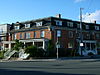 More images | |
| Whitefish Island National Historic Site of Canada | Sault Ste. Marie ON | 46°30′36″N84°21′04″W / 46.5101°N 84.3511°W | Federal (14945) |  More images | |
| Canadian Pacific Railway Station | Winnipeg Street (between Elgin & Durham Streets) White River ON | Federal (4613) | 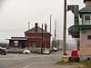 More images |
Cochrane District
| Name | Address | Coordinates | Government recognition (CRHP №) | | Image |
|---|---|---|---|---|---|
| Public Building | 22 Circle Street Kapuskasing ON | 49°25′02″N82°25′29″W / 49.4173°N 82.4248°W | Federal (4063) | Upload Photo | |
| HBC Staff House | 4 Front Street Moose Factory ON | 51°15′08″N80°36′22″W / 51.2523°N 80.6062°W | Ontario (8854) |  More images | |
| HBC Worker's House - McLeod House | 2 Museum Street Moose Factory ON | 51°15′15″N80°36′16″W / 51.2541°N 80.6044°W | Ontario (8855) | 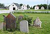 | |
| HBC Worker's House - Sackabuckiskum House | 2 Museum Street Moose Factory ON | 51°15′15″N80°36′13″W / 51.2543°N 80.6036°W | Ontario (8857) | 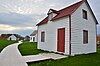 More images | |
| HBC Worker's House - Turner House | 2 Museum Street Moose Factory ON | 51°15′14″N80°36′18″W / 51.2539°N 80.6051°W | Ontario (8856) | Upload Photo | |
| Moose Factory Buildings National Historic Site of Canada | Moosonee ON | 51°16′45″N80°38′20″W / 51.2792°N 80.6389°W | Federal (10481) | More images |
Kenora District
| Name | Address | Coordinates | Government recognition (CRHP №) | | Image |
|---|---|---|---|---|---|
| Kenora Canadian Pacific Railway Station | Railway Street Kenora ON | Federal (4545) |  More images | ||
| Sioux Lookout railway station CNR | 53 Front Street Sioux Lookout ON | 50°05′51″N91°54′59″W / 50.0976°N 91.9164°W | Federal (6906), Ontario (8900) |  More images |
Manitoulin District
| Name | Address | Coordinates | Government recognition (CRHP №) | | Image |
|---|---|---|---|---|---|
| Janet Head Light Tower | Lot 25, West Range Gore Bay (Janet Head) ON | 45°56′48″N82°29′00″W / 45.9466°N 82.4833°W | Federal (16129) |  | |
| Light station Tower | Great Duck Island West Part, Manitoulin ON | 45°39′05″N82°57′12″W / 45.6515°N 82.9534°W | Federal (10937) | Upload Photo | |
| Manitowaning Lighttower | Arthur Street Manitowaning ON | 45°44′41″N81°48′18″W / 45.7448°N 81.8050°W | Federal (21067) |  | |
| Sheguiandah National Historic Site of Canada | Northeastern Manitoulin and the Islands (Sheguiandah) ON | 45°52′42″N81°54′24″W / 45.8782°N 81.9066°W | Federal (14555) | Upload Photo | |
| Fog Alarm | Mississagi Island Unorganized West Manitoulin District ON | 45°53′28″N83°13′32″W / 45.8912°N 83.2256°W | Federal (9603) | Upload Photo | |
| Lighttower | Mississagi Island Unorganized West Manitoulin District ON | 45°53′28″N83°13′32″W / 45.8912°N 83.2256°W | Federal (9623) |  |
Nipissing District
| Name | Address | Coordinates | Government recognition (CRHP №) | | Image |
|---|---|---|---|---|---|
| Canadian National Railway Station | 172 Second Avenue West North Bay ON | Federal (6810) | Upload Photo | ||
| North Bay CNR Station | 214 Second Avenue North Bay ON | 46°18′51″N79°27′40″W / 46.3141°N 79.4611°W | Ontario (8182) | Upload Photo | |
| North Bay CPR Station | 100 Ferguson Street North Bay ON | Federal (6903), Ontario (8183) | Upload Photo | ||
| Power Cavern and Control Building | Canadian Air Defence Sector (CADS) Complex North Bay ON | 46°20′14″N79°24′35″W / 46.3372°N 79.4098°W | Federal (13174) | Upload Photo | |
| Algonquin Provincial Park National Historic Site of Canada | Unorganized South Nipissing District ON | 45°33′00″N78°35′00″W / 45.55°N 78.5833°W | Federal (3249) |  More images |
Rainy River District
| Name | Address | Coordinates | Government recognition (CRHP №) | | Image |
|---|---|---|---|---|---|
| Federal Building | 301 Scott Street Fort Frances ON | 48°36′36″N93°23′43″W / 48.6100°N 93.3953°W | Federal (9485) | Upload Photo | |
| Fort St. Pierre National Historic Site of Canada | Point Park Fort Frances ON | 48°36′55″N93°21′23″W / 48.6153°N 93.3564°W | Federal (18945) | Upload Photo | |
| Former Canadian National Railway Station | 4th Street West (west of Central Avenue) Fort Frances ON | 48°36′49″N93°24′15″W / 48.6135°N 93.4043°W | Federal (6809) |  | |
| Kay-Nah-Chi-Wah-Nung National Historic Site of Canada | Morley (Stratton) ON | 48°38′46″N94°04′30″W / 48.6461°N 94.075°W | Federal (12056) | 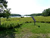 More images |
Sudbury District
| Name | Address | Coordinates | Government recognition (CRHP №) | | Image |
|---|---|---|---|---|---|
| Canadian Pacific Railway Station | Spencer Avenue Cartier ON | 46°42′21″N81°33′27″W / 46.7059°N 81.5576°W | Federal (4608) | 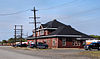 More images | |
| Killarney Lighthouse | Killarney ON | 45°58′06″N81°29′20″W / 45.9682°N 81.4889°W | Federal (9685) | 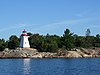 More images | |
| Killarney Northwest Lighthouse | Southern tip of Partridge Island Killarney ON | 45°59′02″N81°31′56″W / 45.9838°N 81.532314°W | Federal (10240) | Upload Photo |
Thunder Bay District
| Name | Address | Coordinates | Government recognition (CRHP №) | | Image |
|---|---|---|---|---|---|
| VIA Rail/Canadian National Railway Station | Railway Avenue (at Main St.) Greenstone (Nakina) ON | 50°10′37″N86°42′47″W / 50.177°N 86.713°W | Federal (6802) |  More images | |
| Pic River Site National Historic Site of Canada | Pic River 50 ON | 48°37′33″N86°16′56″W / 48.6259°N 86.2823°W | Federal (15782) | Upload Photo | |
| Canadian Pacific Railway Station | Brunswick Street Schreiber ON | Federal (4609) |  More images | ||
| Armoury | 317 Park Avenue Thunder Bay ON | 48°26′11″N89°13′41″W / 48.4363°N 89.2281°W | Federal (9616) | Upload Photo | |
| Canadian Car & Foundry National Historic Site of Canada | 1001 Montreal Street Thunder Bay ON | 48°21′32″N89°18′04″W / 48.359°N 89.301°W | Federal (16408) |  | |
| Cummins Pre-contact Site National Historic Site of Canada | Mapleward Road, Cummins Pond Thunder Bay ON | Federal (16843) | Upload Photo | ||
| Federal Building | 130 Syndicate Ave South Thunder Bay ON | 48°22′59″N89°14′52″W / 48.3831°N 89.2478°W | Federal (10463) | Upload Photo | |
| Finnish Labour Temple National Historic Site of Canada | 314 Bay Street Thunder Bay ON | 48°25′56″N89°13′48″W / 48.4322°N 89.2301°W | Federal (18724) |  More images | |
| Lamb Island Lighthouse | Lamb Island, 90km east of Thunder Bay in Lake Huron Thunder Bay ON | 48°36′08″N88°08′37″W / 48.6021°N 88.1435°W | Federal (20797) | Upload Photo | |
| Revenue Canada Building | 201 May Street North Thunder Bay ON | 48°23′13″N89°14′46″W / 48.387°N 89.246°W | Federal (4767) | 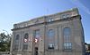 More images | |
| Thunder Bay Tourist Pagoda National Historic Site of Canada | 164 Arthur Street Thunder Bay ON | 48°26′05″N89°13′08″W / 48.4346°N 89.2188°W | Federal (7763) |  More images | |
| Union Station (Canadian Pacific Railway Station) | 440 Syndicate Avenue South Thunder Bay ON | Federal (4546) | More images | ||
| Lighttower | Eastern tip of Davieaux Island, Lake Superior Unorganized Thunder Bay District ON | 47°41′41″N85°48′19″W / 47.6947°N 85.8052°W | Federal (4758) | Upload Photo | |
| Lightstation: Tower | Battle Island, Lake Superior Unorganized Thunder Bay District ON | 48°45′06″N87°33′26″W / 48.7518°N 87.5572°W | Federal (9683) | Upload Photo |
Timiskaming District
| Name | Address | Coordinates | Government recognition (CRHP №) | | Image |
|---|---|---|---|---|---|
| Cobalt Mining District National Historic Site of Canada | Cobalt ON | 47°23′51″N79°40′30″W / 47.3975°N 79.675°W | Federal (4183) | 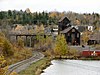 More images | |
| Cobalt O.N.R. Station | 1 Station Road Cobalt ON | 47°23′45″N79°41′03″W / 47.3959°N 79.6842°W | Ontario (10423) |  More images | |
| Sir Harry Oakes Chateau | 2 Chateau Drive Kirkland Lake ON | 48°08′55″N80°02′54″W / 48.1485°N 80.0483°W | Ontario (8170) |  More images |