Whitefish Island

Last updated

Whitefish Island
Whitefish Island Indian Reserve
Soo Locks-Sault-Ste Marie.png
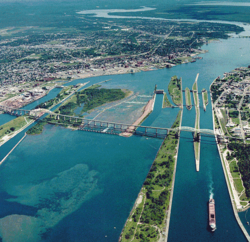
Aerial view of the St. Marys River; Whitefish Island is just to the left of the rapids.
Canada Ontario location map 2.svg
Red pog.svg
Whitefish Island
Coordinates: 46°31′N84°21′W / 46.517°N 84.350°W / 46.517; -84.350
Country Flag of Canada (Pantone).svg  Canada
Province Flag of Ontario.svg  Ontario
District Algoma
First Nation Batchewana
Area
  Land0.17 km2 (0.07 sq mi)
Population
 (2011)
  Total
0
  Density0/km2 (0/sq mi)
Time zone UTC-5 (EST)
  Summer (DST) UTC-4 (EDT)
Website www.batchewana.ca
Official nameWhitefish Island National Historic Site of Canada
Designated1981

Whitefish Island is an island in the St. Marys River, just south of Sault Ste. Marie, in Ontario, Canada.

Contents

History

It was an ancestral fishing station to the Anishenabek of the Great Lakes region for over 2,000 years. It was reserved for the use of Chief Nebenaigoching and his band in the Robinson Huron Treaty, 1850 with the British Crown. In 1895, it became part of the west side of the Sault Ste. Marie Canal.

After it was taken in a series of expropriations from 1902 to 1913 for railway purposes, it became a park in the Parks Canada national inventory. The island was designated a National Historic Site of Canada in 1981. [1]

A land claim was filed in 1982 by the Batchewana Indian Band, of the Batchewana First Nation, for the 22-acre (89,000 m2) island. After years of unsuccessful negotiations, hereditary Chief Edward James Sayers Nebenaigoching occupied the island from 1989 until the claim was settled in 1992. $3.5 million in damages were paid to the tribe, and the island was returned to Indian reserve status in 1997.[ citation needed ]

References