Sault Ste. Marie is a city in the Upper Peninsula of the U.S. state of Michigan. It is the county seat of Chippewa County and is the only city within the county. With a population of 13,337 at the 2020 census, it is the second-most populated city in the Upper Peninsula, behind Marquette. It is the primary city of the Sault Ste. Marie, MI Micropolitan Statistical Area, which encompasses all of Chippewa County and had a population of 36,785 at the 2020 census. Sault Ste. Marie was settled by mostly French colonists in 1668, making it the oldest city in Michigan.

The St. Marys River, sometimes written St. Mary's River, drains Lake Superior, starting at the end of Whitefish Bay and flowing 74.5 miles (119.9 km) southeast into Lake Huron, with a fall of 23 feet (7.0 m). For its entire length it is an international border, separating Michigan in the United States from Ontario, Canada.
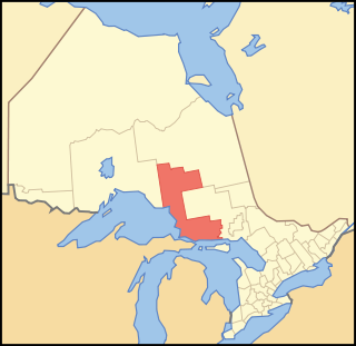
Algoma District is a district and census division in Northeastern Ontario in the Canadian province of Ontario.
The Soo Locks are a set of parallel locks, operated and maintained by the United States Army Corps of Engineers, Detroit District, that enable ships to travel between Lake Superior and the lower Great Lakes. They are located on the St. Marys River between Lake Superior and Lake Huron, between the Upper Peninsula of the U.S. state of Michigan and the Canadian province of Ontario. They bypass the rapids of the river, where the water falls 21 ft (6.4 m). The locks pass an average of 10,000 ships per year, despite being closed during the winter from January through March, when ice shuts down shipping on the Great Lakes. The winter closure period is used to inspect and maintain the locks.
The Sault Ste. Marie International Bridge spans the St. Marys River between the United States and Canada connecting the twin cities of Sault Ste. Marie, Michigan, and Sault Ste. Marie, Ontario. The bridge is operated by the International Bridge Administration under the direction of the Sault Ste. Marie Bridge Authority, a bi-national governing body consisting of four directors appointed by the governor of Michigan and four appointed by the Canadian government-owned Federal Bridge Corporation.
St. Joseph Island is in the northwestern part of Lake Huron. It is part of the Canadian province of Ontario. At 365 km2 (141 sq mi) in area, it is the sixth largest lake island in the world; the second largest island on Lake Huron, following Manitoulin Island; and the third largest of all the islands on the Great Lakes, trailing Manitoulin and Lake Superior's Isle Royale.

The Wolseley expedition was a military force authorized by Canadian Prime Minister John A. Macdonald to confront Louis Riel and the Métis in 1870, during the Red River Rebellion, at the Red River Colony in what is now the province of Manitoba. The expedition was also intended to counter American expansionist sentiments in northern border states. Leaving Toronto in May, the expedition arrived, after a three-month journey in arduous conditions, at Fort Garry on August 24. This extinguished Riel's provisional government and eradicated the threat of the American expansion into western Canada.

The Battle of Mackinac Island was a British victory in the War of 1812. Before the war, Fort Mackinac had been an important American trading post in the straits between Lake Michigan and Lake Huron. It was important for its influence and control over the Native American tribes in the area, which was sometimes referred to in historical documents as "Michilimackinac".

The Huron Central Railway is a railway operating in northern Ontario, Canada. It is operated by Genesee & Wyoming Canada, the Canadian subsidiary of Genesee & Wyoming.

The Sault Ste. Marie Canal is a National Historic Site in Sault Ste. Marie, Ontario, and is part of the national park system, managed by Parks Canada. It includes a lock to bypass the rapids on the St. Marys River.

Fort St. Joseph is a former British outpost on the southernmost point of St. Joseph Island in Ontario, Canada, on Lake Huron. The fort consisted of a blockhouse, powder magazine, bakery building, Indian council house and storehouse surrounded by a palisade.

The Nile Expedition, sometimes called the Gordon Relief Expedition (1884–1885), was a British mission to relieve Major-General Charles George Gordon at Khartoum, Sudan. Gordon had been sent to Sudan to help the Egyptians withdraw their garrisons after the British decided to abandon Sudan in the face of a rebellion led by self-proclaimed Mahdi, Mahommed Ahmed. A contingent of Canadians was recruited to help the British navigate their small boats up the Nile River. The Nile Expedition was the first overseas expedition by Canadians in a British imperial conflict, although the Nile Voyageurs were civilian employees and did not wear uniforms.

SS Kamloops was a Canadian lake freighter that was part of the fleet of Canada Steamship Lines from its launching in 1924 until it sank with all hands in Lake Superior off Isle Royale, Michigan, United States, on or about 7 December 1927.
The Lewis Cass expedition of 1820 was a survey of the western part of Michigan Territory led by Lewis Cass, governor of the territory. On January 14, 1820, United States Secretary of War John C. Calhoun authorized Cass to lead a party of scientists, soldiers, Canadian voyageurs, and Native Americans into the wilderness of western Michigan Territory. The purpose of the expedition was to:

Fort Brady was a frontier fort established in Sault Sainte Marie, Michigan to guard against British incursions from Canada. The original location of the fort, known as Old Fort Brady, was along the Saint Mary's River. Fort Brady was located at this site from 1822 until 1893, when it was moved to a new location on higher ground, known as New Fort Brady. The fort was located at the new site from 1893 until its close in 1944. The site of Old Fort Brady was designated a Michigan State Historic Site in 1956 and listed on the National Register of Historic Places in 1971; New Fort Brady was designated a Michigan State Historic Site in 1970 and listed on the National Register of Historic Places in 1972.

Sault Ste. Marie is a city in Ontario, Canada. The third-largest city in Northern Ontario after Sudbury and Thunder Bay, it is located on the St. Mary's River on the Canada–US border. To the southwest, across the river, is the United States and the city of Sault Ste. Marie, Michigan. The two cities are joined by the Sault Ste. Marie International Bridge, which connects Interstate 75 on the Michigan side to Huron Street on the Ontario side. Shipping traffic in the Great Lakes system bypasses the Saint Mary's Rapids via the American Soo Locks, the world's busiest canal in terms of tonnage that passes through it, while smaller recreational and tour boats use the Canadian Sault Ste. Marie Canal.
The Batchewana First Nation is an Ojibwe First Nation in northern Ontario. Their traditional lands run along the eastern shore of Lake Superior, from Batchawana Bay to Whitefish Island. They were reserved this land in the 1850 Robinson Huron Treaty, but surrendered most of it under the 1859 Pennefather Treaty. Through purchase and land claims, it has reclaimed some territories, including Goulais Bay 15A, Obadjiwan 15E, Rankin Location 15D and Whitefish Island.
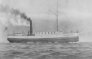
The Independence was a propeller-driven steamboat that was the first steam-driven vessel to run on Lake Superior in October 1845, initiating the era of steam navigation on that lake. During her career, she saw service shipping passengers and supplies to the mining settlements along the south shores of the lake and often returning with copper ore or was commissioned to carry other goods. Her eight-year career on Lake Superior ended when her boilers exploded, killing several aboard, and ultimately sending the steamboat to the bottom in pieces.
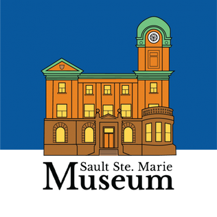
Sault Ste. Marie Museum is a museum in Sault Ste. Marie, Ontario, Canada. Built as a post office from 1902 to 1906, this building became a museum in 1982 when it was purchased by the City of Sault Ste. Marie. It is operated by the Sault Ste. Marie & 49th Field Regiment R.C.A. Historical Society.