Sault Ste. Marie Airport is an international airport located 8.0 nautical miles west-southwest of the city of Sault Ste. Marie, Ontario, Canada at the far eastern end of Lake Superior and the beginning of the St. Mary's River.

Elliot Lake Municipal Airport is a registered aerodrome located 4 nautical miles southeast of the city of Elliot Lake, Ontario, Canada.
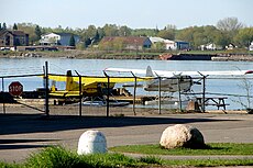
Sault Ste. Marie/Partridge Point Water Aerodrome, formerly TC LID: CNV7, was adjacent to Sault Ste. Marie, Ontario, Canada.

The Sault Ste. Marie Canal is a National Historic Site in Sault Ste. Marie, Ontario, and is part of the national park system, managed by Parks Canada. It includes a lock to bypass the rapids on the St. Marys River.

Canadian Bushplane Heritage Centre (CBHC), located on the north bank of the St. Marys River in Sault Ste. Marie, Ontario, Canada, is dedicated to preserving the history of bush flying and forest protection in Canada. It was founded in 1987 by a group of local volunteers to preserve the province's history in bush planes and aerial firefighting.
Toronto Area Control Center is one of seven area control centers in Canada operated by Nav Canada. The Toronto Area Control Centre is based near Toronto Pearson International Airport in Mississauga, Ontario.

Sault Ste. Marie is a city in Ontario, Canada. The third-largest city in Northern Ontario after Sudbury and Thunder Bay, it is located on the St. Mary's River on the Canada–US border. To the southwest, across the river, is the United States and the Michigan city of the same name. The two cities are joined by the Sault Ste. Marie International Bridge, which connects Interstate 75 on the Michigan side to Huron Street on the Ontario side. Shipping traffic in the Great Lakes system bypasses the Saint Mary's Rapids via the American Soo Locks, the world's busiest canal in terms of tonnage that passes through it, while smaller recreational and tour boats use the Canadian Sault Ste. Marie Canal.
DwightWater Aerodrome is located adjacent to Dwight, Ontario, Canada.
Dwight/South Portage Water Aerodrome is located 2.5 nautical miles west of Dwight, Ontario, Canada.