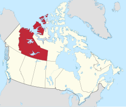
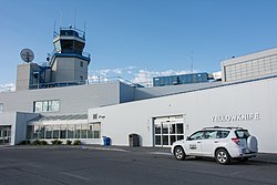
Community Airport name PU PR MI AOE [ A] Operator Elevation ICAO TC LID IATA Image Coordinates Aklavik Aklavik/Freddie Carmichael Airport PU Govt of Northwest Territories 21 ft (6.4 m) CYKD LAK 68°13′24″N 135°00′21″W / 68.22333°N 135.00583°W / 68.22333; -135.00583 (Aklavik/Freddie Carmichael Airport ) Aklavik Aklavik Water Aerodrome PU K & D Contracting 7 ft (2.1 m) CER6 68°13′21″N 134°59′30″W / 68.22250°N 134.99167°W / 68.22250; -134.99167 (Aklavik Water Aerodrome ) Behchokǫ̀ Rae/Edzo Airport PU Til Cho Construction 587 ft (179 m) CRE2 62°46′00″N 116°05′01″W / 62.76667°N 116.08361°W / 62.76667; -116.08361 (Rae/Edzo Airport ) Colville Lake Colville Lake/Tommy Kochon Aerodrome PU Govt of Northwest Territories 899 ft (274 m) CYVL YCK 67°02′00″N 126°05′00″W / 67.03333°N 126.08333°W / 67.03333; -126.08333 (Colville Lake Airport ) Colville Lake Colville Lake Water Aerodrome PU Kapami Co-op Association 801 ft (244 m) CED7 67°02′29″N 126°06′02″W / 67.04139°N 126.10056°W / 67.04139; -126.10056 (Colville Lake Water Aerodrome ) Délı̨nę Déline Airport PU Govt of Northwest Territories 702 ft (214 m) CYWJ YWJ 65°12′40″N 123°26′11″W / 65.21111°N 123.43639°W / 65.21111; -123.43639 (Déline Airport ) Délı̨nę Déline Water Aerodrome PU Charter Community of Déline 512 ft (156 m) CEN7 65°11′00″N 123°25′00″W / 65.18333°N 123.41667°W / 65.18333; -123.41667 (Déline Water Aerodrome ) Diavik Diamond Mine Diavik Airport PR Diavik Diamond Mines 1,416 ft (432 m) CDK2 64°30′41″N 110°17′22″W / 64.51139°N 110.28944°W / 64.51139; -110.28944 (Diavik Airport ) Ekati Diamond Mine Ekati Airport PR Arctic Canadian Diamond Company 1,536 ft (468 m) CYOA YOA 64°41′56″N 110°36′53″W / 64.69889°N 110.61472°W / 64.69889; -110.61472 (Ekati Airport ) Ford Bay,Great Bear Lake Ford Bay Airport PR Trophy Lodge 673 ft (205 m) CBC2 66°02′15″N 124°42′54″W / 66.03750°N 124.71500°W / 66.03750; -124.71500 (Ford Bay Airport ) Ford Bay,Great Bear Lake Ford Bay Water Aerodrome PR Trophy Lodge 512 ft (156 m) CEL7 66°02′00″N 124°41′00″W / 66.03333°N 124.68333°W / 66.03333; -124.68333 (Ford Bay Water Aerodrome ) Fort Good Hope Fort Good Hope Airport PU Govt of Northwest Territories 267 ft (81 m) CYGH YGH 66°14′27″N 128°39′03″W / 66.24083°N 128.65083°W / 66.24083; -128.65083 (Fort Good Hope Airport ) Fort Liard Fort Liard Airport PU Govt of Northwest Territories 708 ft (216 m) CYJF YJF 60°14′08″N 123°28′12″W / 60.23556°N 123.47000°W / 60.23556; -123.47000 (Fort Liard Airport ) Fort McPherson Fort McPherson Airport PU Govt of Northwest Territories 115 ft (35 m) CZFM ZFM 67°24′27″N 134°51′38″W / 67.40750°N 134.86056°W / 67.40750; -134.86056 (Fort McPherson Airport ) Fort Providence Fort Providence Airport PU Govt of Northwest Territories 525 ft (160 m) CYJP 61°19′09″N 117°36′22″W / 61.31917°N 117.60611°W / 61.31917; -117.60611 (Fort Providence Airport ) Fort Reliance Fort Reliance Water Aerodrome PU Lutselk'e Dene Council 514 ft (157 m) CJN8 62°42′00″N 109°10′00″W / 62.70000°N 109.16667°W / 62.70000; -109.16667 (Fort Reliance Water Aerodrome ) Fort Resolution Fort Resolution Airport PU Govt of Northwest Territories 527 ft (161 m) CYFR YFR 61°10′51″N 113°41′23″W / 61.18083°N 113.68972°W / 61.18083; -113.68972 (Fort Resolution Airport ) Fort Simpson Fort Simpson Airport PU Govt of Northwest Territories 556 ft (169 m) CYFS YFS 61°45′37″N 121°14′11″W / 61.76028°N 121.23639°W / 61.76028; -121.23639 (Fort Simpson Airport ) Fort Simpson Fort Simpson (Great Slave No. 1) Heliport PR Govt of Northwest Territories 500 ft (150 m) CFS2 61°50′18″N 121°19′35″W / 61.83833°N 121.32639°W / 61.83833; -121.32639 (Fort Simpson/(Great Slave No. 1) Heliport ) Fort Simpson Fort Simpson (Great Slave No. 2) Heliport PR Govt of Northwest Territories 48 ft (15 m) CFD8 61°50′12″N 121°19′30″W / 61.83667°N 121.32500°W / 61.83667; -121.32500 (Fort Simpson/(Great Slave No. 2) Heliport ) Fort Simpson Fort Simpson Island Airport PR Simpson Air 405 ft (123 m) CET4 61°52′00″N 121°21′58″W / 61.86667°N 121.36611°W / 61.86667; -121.36611 (Fort Simpson Island Airport ) Fort Simpson Fort Simpson Island Water Aerodrome PR Wolverine Air / Simpson Air 375 ft (114 m) CEZ7 61°52′00″N 121°22′00″W / 61.86667°N 121.36667°W / 61.86667; -121.36667 (Fort Simpson Island Water Aerodrome ) Fort Smith Fort Smith Airport PU Govt of Northwest Territories 673 ft (205 m) CYSM YSM 60°01′13″N 111°57′43″W / 60.02028°N 111.96194°W / 60.02028; -111.96194 (Fort Smith Airport ) Fort Smith Fort Smith (District) Heliport PR Department of Environment & Climate Change,Govt of Northwest Territories 665 ft (203 m) CEC5 60°00′11″N 111°54′34″W / 60.00306°N 111.90944°W / 60.00306; -111.90944 (Fort Smith (District) Heliport ) Frank Channel Frank Channel (Forestry) Heliport PR Department of Environment & Climate Change,Govt of Northwest Territories 520 ft (160 m) CFB2 62°47′10″N 115°56′45″W / 62.78611°N 115.94583°W / 62.78611; -115.94583 (Frank Channel (Forestry) Heliport ) Gahcho Kue Diamond Mine Gahcho Kue Aerodrome PR De Beers Canada 1,429 ft (436 m) CGK2 63°26′07″N 109°08′41″W / 63.43528°N 109.14472°W / 63.43528; -109.14472 (Gahcho Kue Aerodrome ) Gamèti Gamètì/Rae Lakes Airport PU Govt of Northwest Territories 724 ft (221 m) CYRA YRA 64°06′58″N 117°18′35″W / 64.11611°N 117.30972°W / 64.11611; -117.30972 (Gamètì/Rae Lakes Airport ) Graham Lake Graham Lake (Yellow Dog Lodge) Water Aerodrome PR Yellow Dog Lodge 725 ft (221 m) CYD2 62°53′28″N 113°52′04″W / 62.89111°N 113.86778°W / 62.89111; -113.86778 (Graham Lake (Yellow Dog Lodge) Water Aerodrome ) Great Bear Lake Great Bear Lake Airport PR Plummers Great Bear Lake Lodge 551 ft (168 m) CFF4 DAS 66°42′11″N 119°43′02″W / 66.70306°N 119.71722°W / 66.70306; -119.71722 (Great Bear Lake Airport ) Great Bear Lake Great Bear Lake Water Aerodrome PU Plummers Great Bear Lake Lodge 512 ft (156 m) CES9 66°42′30″N 119°41′00″W / 66.70833°N 119.68333°W / 66.70833; -119.68333 (Great Bear Lake Water Aerodrome ) Great Slave Lake Taltheilei Narrows Airport PR Plummers Great Slave Lake Lodge 617 ft (188 m) CFA7 62°35′50″N 111°32′28″W / 62.59722°N 111.54111°W / 62.59722; -111.54111 (Taltheilei Narrows Airport ) Great Slave Lake Taltheilei Narrows Water Aerodrome PR Plummers Great Slave Lake Lodge 514 ft (157 m) CED9 62°36′00″N 111°31′00″W / 62.60000°N 111.51667°W / 62.60000; -111.51667 (Taltheilei Narrows Water Aerodrome ) Hay River Hay River/Merlyn Carter Airport PU Govt of Northwest Territories 541 ft (165 m) CYHY YHY 60°50′23″N 115°46′58″W / 60.83972°N 115.78278°W / 60.83972; -115.78278 (Hay River/Merlyn Carter Airport ) Hay River Hay River (District) Heliport PR Department of Environment & Natural Resources,Govt of Northwest Territories 550 ft (170 m) CET5 60°47′04″N 115°49′33″W / 60.78444°N 115.82583°W / 60.78444; -115.82583 (Hay River (District) Heliport ) Hay River Hay River Water Aerodrome PR Carter Air Service 514 ft (157 m) CEF8 60°51′07″N 115°43′50″W / 60.85194°N 115.73056°W / 60.85194; -115.73056 (Hay River Water Aerodrome ) Inuvik Inuvik (Mike Zubko) Airport PU 15 [ 5] Govt of Northwest Territories 223 ft (68 m) CYEV YEV 68°18′14″N 133°28′59″W / 68.30389°N 133.48306°W / 68.30389; -133.48306 (Inuvik (Mike Zubko) Airport ) Inuvik Inuvik/Shell Lake Water Aerodrome PU 15 [ 6] [ B] North-Wright Airways 57 ft (17 m) CEE3 68°19′28″N 133°38′04″W / 68.32444°N 133.63444°W / 68.32444; -133.63444 (Inuvik/Shell Lake Water Aerodrome ) Jean Marie River Jean Marie River Airport PU Govt of Northwest Territories 457 ft (139 m) CET9 61°31′21″N 120°37′30″W / 61.52250°N 120.62500°W / 61.52250; -120.62500 (Jean Marie River Airport ) Kasba Lake Kasba Lake Airport PR Kasba Lake Lodge 1,143 ft (348 m) CJL8 60°17′27″N 102°30′11″W / 60.29083°N 102.50306°W / 60.29083; -102.50306 (Kasba Lake Airport ) Kasba Lake Kasba Lake Water Aerodrome PR Kasba Lake Lodge 1,089 ft (332 m) CJP5 60°17′00″N 102°31′00″W / 60.28333°N 102.51667°W / 60.28333; -102.51667 (Kasba Lake Water Aerodrome ) Łutselk'e Lutselk'e Airport PU Govt of Northwest Territories 586 ft (179 m) CYLK 62°25′06″N 110°40′56″W / 62.41833°N 110.68222°W / 62.41833; -110.68222 (Lutselk'e Airport ) Łutselk'e Lutselk'e Water Aerodrome PU Łutselk'e Dene Council 514 ft (157 m) CEB9 62°24′00″N 110°45′00″W / 62.40000°N 110.75000°W / 62.40000; -110.75000 (Lutselk'e Water Aerodrome ) Nahanni Butte Nahanni Butte Airport PU Govt of Northwest Territories 598 ft (182 m) CBD6 61°01′47″N 123°23′20″W / 61.02972°N 123.38889°W / 61.02972; -123.38889 (Nahanni Butte Airport ) Nahanni National Park Reserve Náįlįcho Water Aerodrome PR Nahanni National Park Reserve 2,200 ft (670 m) CFV5 61°36′27″N 125°45′24″W / 61.60750°N 125.75667°W / 61.60750; -125.75667 (Náįlįcho Water Aerodrome ) Namushka LodgeHarding Lake ) Namushka Lodge Water Aerodrome PR Namuska Lodge 670 ft (200 m) CEP9 62°25′00″N 113°21′00″W / 62.41667°N 113.35000°W / 62.41667; -113.35000 (Namushka Lodge Water Aerodrome ) Norman Wells Norman Wells Airport PU Govt of Northwest Territories 237 ft (72 m) CYVQ YVQ 65°16′54″N 126°47′54″W / 65.28167°N 126.79833°W / 65.28167; -126.79833 (Norman Wells Airport ) Norman Wells Norman Wells Water Aerodrome PR Northwright Air Ltd. 200 ft (61 m) CEU8 65°15′29″N 126°41′29″W / 65.25806°N 126.69139°W / 65.25806; -126.69139 (Norman Wells Water Aerodrome ) North of Sixty Fishing Camps Obre Lake/North of Sixty Airport PR North of Sixty Fishing Camps 1,202 ft (366 m) CKV4 YDW 60°18′56″N 103°07′54″W / 60.31556°N 103.13167°W / 60.31556; -103.13167 (Obre Lake/North of Sixty Airport ) North of Sixty Fishing Camps Obre Lake/North of Sixty Water Aerodrome PR North of Sixty Fishing Camps 1,150 ft (350 m) CKP8 60°19′13″N 103°07′36″W / 60.32028°N 103.12667°W / 60.32028; -103.12667 (Obre Lake/North of Sixty Water Aerodrome ) Paulatuk Paulatuk (Nora Aliqatchialuk Ruben) Airport PU Govt of Northwest Territories 15 ft (4.6 m) CYPC YPC 69°21′38″N 124°04′33″W / 69.36056°N 124.07583°W / 69.36056; -124.07583 (Paulatuk (Nora Aliqatchialuk Ruben) Airport ) Paulatuk Paulatuk Water Aerodrome PU Hamlet 0 ft (0 m) CEW8 69°21′00″N 124°04′00″W / 69.35000°N 124.06667°W / 69.35000; -124.06667 (Paulatuk Water Aerodrome ) Prairie Creek Prairie Creek Airport PR Canadian Zinc Corp. 2,950 ft (900 m) CBH4 61°33′53″N 124°48′54″W / 61.56472°N 124.81500°W / 61.56472; -124.81500 (Prairie Creek Airport ) Sachs Harbour Sachs Harbour (David Nasogaluak Jr. Saaryuaq) Airport PU Govt of Northwest Territories 283 ft (86 m) CYSY YSY 71°59′38″N 125°14′33″W / 71.99389°N 125.24250°W / 71.99389; -125.24250 (Sachs Harbour Airport ) Sambaa K'e Sambaa K'e Aerodrome PU Govt of Northwest Territories 1,666 ft (508 m) CEU9 60°25′25″N 121°16′11″W / 60.42361°N 121.26972°W / 60.42361; -121.26972 (Sambaa K'e Aerodrome ) Sambaa K'e Sambaa K'e Water Aerodrome PU Sambaa K'e First Nation 1,623 ft (495 m) CEG9 60°26′32″N 121°14′10″W / 60.44222°N 121.23611°W / 60.44222; -121.23611 (Sambaa K'e Water Aerodrome ) Snare River Snare River Airport PR Northwest Territories Power Corporation 700 ft (210 m) CEV9 63°26′00″N 116°11′00″W / 63.43333°N 116.18333°W / 63.43333; -116.18333 (Snare River Airport ) Taltson River Taltson River Airport PR Northwest Territories Power Corporation 875 ft (267 m) CFW5 60°23′39″N 111°20′50″W / 60.39417°N 111.34722°W / 60.39417; -111.34722 (Taltson River Airport ) Tuktoyaktuk Tuktoyaktuk/James Gruben Airport PU 15 [ 7] Govt of Northwest Territories 14 ft (4.3 m) CYUB YUB 69°26′00″N 133°01′35″W / 69.43333°N 133.02639°W / 69.43333; -133.02639 (Tuktoyaktuk/James Gruben Airport ) Tulita Tulita Airport PU Govt of Northwest Territories 329 ft (100 m) CZFN ZFN 64°54′35″N 125°34′21″W / 64.90972°N 125.57250°W / 64.90972; -125.57250 (Tulita Airport ) Tundra Mine / Salmita Mine Tundra Mine/Salamita [ sic ] Mine Aerodrome PR Indigenous and Northern Affairs Canada 1,382 ft (421 m) CTM7 64°04′22″N 111°09′48″W / 64.07278°N 111.16333°W / 64.07278; -111.16333 (Tundra Mine/Salamita Mine Aerodrome ) Tungsten Tungsten (Cantung) Airport PR North American Tungsten Corp 3,651 ft (1,113 m) CBX5 61°57′25″N 128°12′10″W / 61.95694°N 128.20278°W / 61.95694; -128.20278 (Tungsten (Cantung) Airport ) Ulukhaktok Ulukhaktok Airport PU Govt of Northwest Territories 118 ft (36 m) CYHI YHI 70°45′46″N 117°48′22″W / 70.76278°N 117.80611°W / 70.76278; -117.80611 (Ulukhaktok Airport ) Wekweètì Wekweètì Airport PU Govt of Northwest Territories 1,208 ft (368 m) CYWE 64°11′27″N 114°04′36″W / 64.19083°N 114.07667°W / 64.19083; -114.07667 (Wekweètì Airport ) Whatì Whatì Airport PU Govt of Northwest Territories 882 ft (269 m) CEM3 63°07′54″N 117°14′46″W / 63.13167°N 117.24611°W / 63.13167; -117.24611 (Whatì Airport ) Whatì Whatì Water Aerodrome PU Whatì Hamlet 870 ft (270 m) CEQ8 63°09′00″N 117°16′00″W / 63.15000°N 117.26667°W / 63.15000; -117.26667 (Whatì Water Aerodrome ) Wrigley Wrigley Airport PU Govt of Northwest Territories 490 ft (150 m) CYWY YWY 63°12′34″N 123°26′12″W / 63.20944°N 123.43667°W / 63.20944; -123.43667 (Wrigley Airport ) Yellowknife Yellowknife Airport PU 15 [ 8] Govt of Northwest Territories 675 ft (206 m) CYZF YZF 62°27′46″N 114°26′25″W / 62.46278°N 114.44028°W / 62.46278; -114.44028 (Yellowknife Airport ) Yellowknife Yellowknife Water Aerodrome PU Ahmic AirAir Tindi 514 ft (157 m) CEN9 62°28′00″N 114°21′00″W / 62.46667°N 114.35000°W / 62.46667; -114.35000 (Yellowknife Water Aerodrome )