Jean Marie River Airport

Last updated
Jean Marie River Airport
Summary
Airport typePublic
OperatorGovernment of the Northwest Territories
Location Jean Marie River, Northwest Territories
Time zone MST (UTC−07:00)
  Summer (DST)MDT (UTC−06:00)
Elevation  AMSL 457 ft / 139 m
Coordinates 61°31′21″N120°37′30″W / 61.52250°N 120.62500°W / 61.52250; -120.62500 Coordinates: 61°31′21″N120°37′30″W / 61.52250°N 120.62500°W / 61.52250; -120.62500
Map
NWT All Region Locator.svg
Airplane silhouette.svg
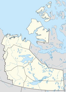
CET9
Location in the Northwest Territories
Canada location map 2.svg
Airplane silhouette.svg
CET9
CET9 (Canada)
Runways
Direction LengthSurface
ftm
11/292,512766Gravel/clay

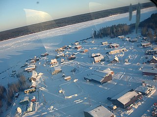
Jean Marie River Airport( TC LID : CET9) is located adjacent to Jean Marie River, Northwest Territories, Canada.

Related Research Articles

Sault Ste. Marie Airport

Sault Ste. Marie Airport,, is an international airport located 8.0 nautical miles west-southwest of the city of Sault Ste. Marie, Ontario, Canada at the far eastern end of Lake Superior and the beginning of the St. Mary's River.

Sault Ste. Marie Water Aerodrome

Sault Ste. Marie Water Aerodrome,, is located adjacent on the St. Marys River in Sault Ste. Marie, Ontario, Canada. It shares its airspace and waterway with neighbouring Sault Ste Marie International Seaplane Base in the United States.

Jean Marie River Place in Northwest Territories, Canada

Jean Marie River is a "Designated Authority" in the Dehcho Region of the Northwest Territories, Canada. The community is located on the Jean Marie River where it joins the Mackenzie River. The community has a small airport, Jean Marie River Airport, and is accessible by charter aircraft throughout the year and by the all-season JMR Access Road 27 km (17 mi) from the Mackenzie Highway.

References

  1. Canada Flight Supplement. Effective 0901Z 16 July 2020 to 0901Z 10 September 2020.