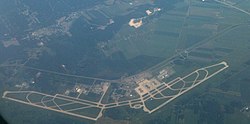
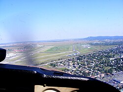
List of airports in the Montreal area

Last updated

Montreal-blank.png
Red pog.svg
CYMX
Red pog.svg
CYUL
Red pog.svg
CSA4
Red pog.svg
CHA3
Red pog.svg
CSW5
Red pog.svg
CSH9
Red pog.svg
CHS5
Red pog.svg
CSN2
Red pog.svg
CLP2
Red pog.svg
CCH5
Red pog.svg
CMH4
Red pog.svg
CPZ6
Red pog.svg
CSZ8
Red pog.svg
CYCV (H)
Red pog.svg
CVP2 (H)
Red pog.svg
CST8 (H)
Red pog.svg
CYMY (H)
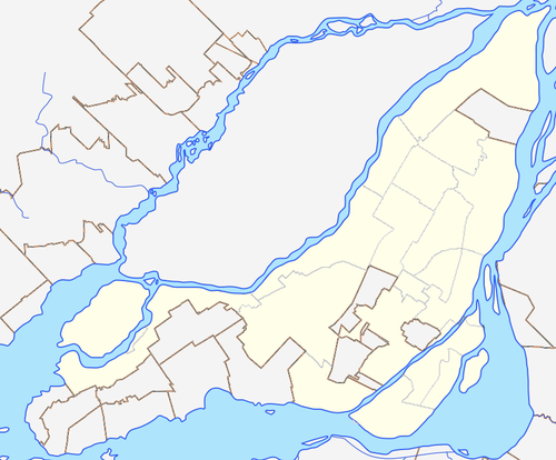
Location in Montreal. Airports marked "(H)" are historical.
Canada Quebec relief location map.jpg
Red pog.svg
Montreal
Location in Quebec

The following active airports serve the area around Montreal, Quebec, Canada, lying underneath or immediately adjacent to Montreal's terminal control area: [1] [2]

Contents

Montreal-Pierre Elliot Trudeau International Airport terminal and control tower Montreal-Pierre Elliot Trudeau International Airport terminal and control tower.jpg
Montréal-Pierre Elliot Trudeau International Airport terminal and control tower
Montreal-Mirabel International Airport Mirabel-International.jpg
Montréal–Mirabel International Airport
Montreal Saint-Hubert Longueuil Airport Montreal-Saint-Hubert Airport.jpg
Montreal Saint-Hubert Longueuil Airport
The former Cartierville Airport Saint-Laurent Cartierville Airport 1946.jpg
The former Cartierville Airport

Land based airports

Scheduled commercial airline service

Airport name ICAO/TC LID/IATA LocationCoordinates
Montréal–Mirabel International Airport CYMX (YMX) Mirabel 45°40′55″N074°00′19″W / 45.68194°N 74.00528°W / 45.68194; -74.00528 (Montreal-Mirabel International Airport)
Montréal–Trudeau International Airport CYUL (YUL) Dorval 45°28′14″N073°44′27″W / 45.47056°N 73.74083°W / 45.47056; -73.74083 (Montréal-Pierre Elliot Trudeau International Airport)
Montreal Saint-Hubert Longueuil Airport CYHU (YHU) Saint-Hubert, Longueuil 45°31′03″N073°25′01″W / 45.51750°N 73.41694°W / 45.51750; -73.41694 (Montréal/Saint-Hubert Airport)

Other

Airport name ICAO/TC LID/IATA LocationCoordinates
Alexandria Aerodrome CNS4 North Glengarry, Ontario 45°20′00″N074°37′00″W / 45.33333°N 74.61667°W / 45.33333; -74.61667 (Alexandria Aerodrome)
Hawkesbury Airport CNV4 Hawkesbury, Ontario 45°37′00″N074°39′00″W / 45.61667°N 74.65000°W / 45.61667; -74.65000 (Hawkesbury Airport)
Hawkesbury (East) Airport CPG5 Hawkesbury, Ontario 45°34′58″N074°32′56″W / 45.58278°N 74.54889°W / 45.58278; -74.54889 (Hawkesbury (East) Airport)
Lac Agile (Mascouche) Airport CSA2 Mascouche 45°47′31″N073°38′17″W / 45.79194°N 73.63806°W / 45.79194; -73.63806 (Lac Agile (Mascouche) Airport)
Lachute Airport CSE4 Lachute 45°38′22″N074°22′14″W / 45.63944°N 74.37056°W / 45.63944; -74.37056 (Lachute Airport)
Montréal/Aéroparc Île Perrot CSP6 Montreal 45°22′34″N073°54′26″W / 45.37611°N 73.90722°W / 45.37611; -73.90722 (Montréal/Aéroparc Île Perrot)
Montréal/Les Cèdres Airport CSS3 Les Cèdres 45°20′51″N074°04′36″W / 45.34750°N 74.07667°W / 45.34750; -74.07667 (Montréal/Les Cèdres Airport)
Montréal/Saint-Lazare Aerodrome CST3 Saint-Lazare 45°23′33″N074°08′03″W / 45.39250°N 74.13417°W / 45.39250; -74.13417 (Montréal/Saint-Lazare Aerodrome)
Saint-Jean Airport CYJN (YJN) Saint-Jean-sur-Richelieu 45°17′40″N073°16′52″W / 45.29444°N 73.28111°W / 45.29444; -73.28111 (Saint-Jean-sur-Richelieu Airport)
Saint-Mathias Aerodrome CSP5 Saint-Mathias-sur-Richelieu 45°30′03″N073°14′30″W / 45.50083°N 73.24167°W / 45.50083; -73.24167 (Saint-Mathias Aerodrome)
Saint-Mathias/Grant Aerodrome CSX5 Saint-Mathias-sur-Richelieu 45°28′19″N073°11′58″W / 45.47194°N 73.19944°W / 45.47194; -73.19944 (Saint-Mathias/Grant Aerodrome)
Saint-Mathieu-de-Beloeil Aerodrome CSB3 Saint-Mathieu-de-Beloeil 45°35′24″N073°14′19″W / 45.59000°N 73.23861°W / 45.59000; -73.23861 (Saint-Mathieu-de-Beloeil Aerodrome)
Salaberry-de-Valleyfield Aerodrome CSD3 Salaberry-de-Valleyfield 45°12′30″N074°08′29″W / 45.20833°N 74.14139°W / 45.20833; -74.14139 (Salaberry de Valleyfield Aerodrome)
Richelieu Airport CSX3 Richelieu 45°26′52″N073°14′03″W / 45.44778°N 73.23417°W / 45.44778; -73.23417 (Richelieu Airport)
Richelieu/Messier Aerodrome CRM3 Richelieu 45°22′41″N073°13′37″W / 45.37806°N 73.22694°W / 45.37806; -73.22694 (Richelieu/Messier Aerodrome)

Montréal-Trudeau (formerly known as Dorval) handles the scheduled passenger service for Montreal. Mirabel formerly also handled scheduled passenger service, but it has been discontinued and the airport is little used. Saint-Hubert is the major general aviation reliever for the city, though Trudeau also sees a lot of general aviation traffic.

Plattsburgh International Airport in Plattsburgh, New York, markets itself as "Montreal's U.S. airport". The airport is 97 km (60 mi) from Montreal, and closer than Trudeau to the South Shore. More than 80% of passengers departing Plattsburgh Airport are Canadian. [3] [4] [5] [6]

Water aerodromes

Airport name ICAO/TC LID/IATA LocationCoordinates
Montréal/Boisvert & Fils Water Airport CSA4 Rivière des Prairies, Montreal 45°38′44″N073°35′49″W / 45.64556°N 73.59694°W / 45.64556; -73.59694 (Montréal/Boisvert & Fils Water Airport)
Montréal/Hydro Aéroport de Montréal Water Airport CHA3 Saint Lawrence River, Longueuil, Montreal 45°32′40″N073°30′55″W / 45.54444°N 73.51528°W / 45.54444; -73.51528 (Montréal/Hydro Aéroport de Montréal Water Airport)
Saint-Mathias Water Aerodrome CSV9 Richelieu River, Saint-Mathias-sur-Richelieu 45°30′10″N073°15′08″W / 45.50278°N 73.25222°W / 45.50278; -73.25222 (Saint-Mathias Water Aerodrome)

Heliports

Airport name ICAO/TC LID/IATA LocationCoordinates
Montréal (Bell) Heliport CSW5 Montreal 45°41′06″N073°55′52″W / 45.68500°N 73.93111°W / 45.68500; -73.93111 (Montréal (Bell) Heliport)
Montréal East (AIM) Heliport CSH9 Montreal 45°38′09″N073°33′44″W / 45.63583°N 73.56222°W / 45.63583; -73.56222 (Montréal East (AIM) Heliport)
Montréal/Heliport Senneville CHS5 Montreal 45°26′34″N073°57′38″W / 45.44278°N 73.96056°W / 45.44278; -73.96056 (Montréal/Heliport Senneville)
Montréal/Kruger Heliport CSN2 Montreal 45°30′25″N073°38′09″W / 45.50694°N 73.63583°W / 45.50694; -73.63583 (Montréal/Kruger Heliport)
Montréal/Laval (Artopex Plus) Heliport CLP2 Montreal 45°34′43″N073°45′00″W / 45.57861°N 73.75000°W / 45.57861; -73.75000 (Montréal/Laval (Artopex Plus) Heliport)
Montréal/Les Cèdres Heliport CSH6 Les Cèdres 45°21′00″N074°05′00″W / 45.35000°N 74.08333°W / 45.35000; -74.08333 (Montréal/Les Cèdres Heliport)
Montréal/Longueuil (Centre Hospitalier Pierre-Boucher) Heliport CCH5Hôpital Pierre Boucher, Montreal 45°32′17″N073°27′36″W / 45.53806°N 73.46000°W / 45.53806; -73.46000 (Montréal/Longueuil (Centre hospitalier Pierre-Boucher) Heliport)
Montréal/Mirabel Hélico Heliport CMH4 Montreal 45°41′44″N073°57′09″W / 45.69556°N 73.95250°W / 45.69556; -73.95250 (Montréal/Mirabel Hélico Heliport)
Montréal/Passport Hélico Heliport CPP8 Montreal 45°43′21″N073°35′43″W / 45.72250°N 73.59528°W / 45.72250; -73.59528 (Montréal/Passport Hélico Heliport)
Montréal/Point Zero Heliport CPZ6 Montreal 45°31′47″N073°39′27″W / 45.52972°N 73.65750°W / 45.52972; -73.65750 (Montréal/Point Zero Heliport)
Montréal/Saint-Hubert Heli-Inter Heliport CTG2 Saint-Hubert, Longueuil 45°31′57″N073°24′42″W / 45.53250°N 73.41167°W / 45.53250; -73.41167 (Montréal/Saint-Hubert Helicraft Heliport)
Montréal (Sacre-Coeur) Heliport CSZ8 Hôpital du Sacré-Cœur de Montréal, Montreal 45°31′58″N073°42′44″W / 45.53278°N 73.71222°W / 45.53278; -73.71222 (Montréal (Sacre-Coeur) Heliport)
Valleyfield (Ciment Deval Inc) Heliport CSY5 Salaberry-de-Valleyfield 45°15′49″N074°08′57″W / 45.26361°N 74.14917°W / 45.26361; -74.14917 (Valleyfield (Transport BRS Inc) Heliport)

Historical airports

Airport name ICAO/TC LID/IATA LocationCoordinates
Cartierville Airport CYCV (YCV) Saint-Laurent 45°31′00″N073°43′00″W / 45.51667°N 73.71667°W / 45.51667; -73.71667 (Cartierville Airport)
Chambly Airport CTT2 Chambly 45°24′04″N073°17′43″W / 45.40111°N 73.29528°W / 45.40111; -73.29528 (Chambly Airport)
Hawkesbury (Windover Field) Airport CPD8 Hawkesbury, Ontario 45°33′52″N074°48′35″W / 45.56444°N 74.80972°W / 45.56444; -74.80972 (Hawkesbury (Windover Field) Airport)
Montréal/Boucherville Water Aerodrome CTA7 Boucherville 45°37′40″N073°27′17″W / 45.62778°N 73.45472°W / 45.62778; -73.45472 (Montréal/Boucherville Water Aerodrome)
Montréal/Île Sainte-Hélène Water Airport CVP2 Saint Helen's Island, Montreal 45°31′15″N073°32′20″W / 45.52083°N 73.53889°W / 45.52083; -73.53889 (Montréal/Île Sainte-Hélène Water Airport)
Montréal/Marina Venise Water Airport CST8 Rivière des Mille Îles, Montreal 45°37′59″N073°46′59″W / 45.63306°N 73.78306°W / 45.63306; -73.78306 (Montréal/Marina Venise Water Airport)
Montréal/Mascouche Airport CSK3 Mascouche 45°43′07″N073°35′53″W / 45.71861°N 73.59806°W / 45.71861; -73.59806 (Montréal/Mascouche Airport)
CFB St. Hubert Montreal 45°30′47″N073°25′20″W / 45.51306°N 73.42222°W / 45.51306; -73.42222 (RCAF Station St Hubert)
Victoria STOLport CYMY (YMY) Montreal 45°28′57″N073°32′55″W / 45.48250°N 73.54861°W / 45.48250; -73.54861 (Victoria STOLport)

Related Research Articles

<span class="mw-page-title-main">Greater Moncton Roméo LeBlanc International Airport</span> International airport serving Moncton, New Brunswick, Canada

Greater Moncton Roméo LeBlanc International Airport or Moncton/Greater Moncton Roméo LeBlanc International Airport is located in the city of Dieppe 4 nautical miles east northeast of downtown Moncton, New Brunswick, Canada. Originally named Greater Moncton International Airport, the airport was renamed in 2016, in honour of former Governor General Roméo LeBlanc.

<span class="mw-page-title-main">Montréal–Trudeau International Airport</span> Airport in Dorval, Quebec, Canada

Montréal–Trudeau International Airport or Montréal–Trudeau, formerly known and still commonly referred to as Montréal–Dorval International Airport, is an international airport in Dorval, Quebec, Canada. It is the only Transport Canada designated international airport serving Montreal and is situated 20 km (12 mi) west of Downtown Montreal. The airport terminals are located entirely in the suburb of Dorval, while one runway is located in the Montreal borough of Saint-Laurent. Air Canada, the country's flag carrier, also has its corporate headquarters complex on the Saint-Laurent side of the airport. It also serves Greater Montreal and adjacent regions in Quebec and eastern Ontario, as well as the states of Vermont and northern New York in the United States. The airport is named in honour of Pierre Elliott Trudeau, the 15th Prime Minister of Canada and father of current Prime Minister Justin Trudeau.

<span class="mw-page-title-main">Montréal–Mirabel International Airport</span> Airport in Mirabel, Quebec, Canada

Montréal–Mirabel International Airport, originally called Montréal International Airport, widely known as Mirabel and branded as YMX International Aerocity of Mirabel, is a cargo and former international passenger airport in Mirabel, Quebec, Canada, 21 nautical miles northwest of Montreal. It opened on October 4, 1975, and the last commercial passenger flight took off on October 31, 2004.

<span class="mw-page-title-main">Montreal Saint-Hubert Longueuil Airport</span> Airport in the Saint-Hubert borough of Longueuil, Quebec, Canada

Montréal Saint-Hubert Longueuil Airport, also called Montréal/Saint-Hubert Airport, is located in the Saint-Hubert borough of Longueuil, Quebec. The airport is located 16 km (9.9 mi) east of Downtown Montreal and 3 nautical miles east of Longueuil.

<span class="mw-page-title-main">Ottawa Macdonald–Cartier International Airport</span> Airport in Ontario, Canada

Ottawa/Macdonald–Cartier International Airport or Macdonald–Cartier International Airport is the main international airport serving Ottawa, Ontario, Canada, and its metropolitan area known as the National Capital Region. It is named after the Canadian statesmen and two of the "founding fathers of Canada", Sir John A. Macdonald and Sir George-Étienne Cartier. Located 5.5 nautical miles south of downtown Ottawa in the south end of the city, it is Canada's eighth-busiest airport, Ontario's second-busiest airport by airline passenger traffic, with 2,992,334 passengers in 2022. The airport was the home base for First Air.

Lachute Airport is a general aviation airport 1 nautical mile southwest of Lachute, northwest of Montreal, Quebec, Canada.

<span class="mw-page-title-main">Kapuskasing Airport</span> Airport in northern Ontario, Canada

Kapuskasing Airport is located 2 nautical miles west of the town of Kapuskasing in northern Ontario, Canada. The airport formerly handled scheduled passenger service through Bearskin Airlines, which flew to Timmins but that service was discontinued at the end of June 2017. It is an airport of entry, providing customs services for general aviation flights arriving directly from the United States.

<span class="mw-page-title-main">Timmins Victor M. Power Airport</span> Airport in Ontario, Canada

Timmins Victor M. Power Airport is located 6 nautical miles north-northwest of Timmins, Ontario, Canada. The airport serves both scheduled passenger and cargo flights and general aviation, including air ambulance (MEDEVAC), forest-fire fighting, and flight training.

<span class="mw-page-title-main">Cranbrook/Canadian Rockies International Airport</span> International airport in southeastern British Columbia, Canada

Cranbrook/Canadian Rockies International Airport is an international airport located 5 nautical miles north of Cranbrook and 20 km (12 mi) south-east of Kimberley, British Columbia, in the Canadian Rockies.

Billy Bishop Toronto City Water Aerodrome is located in Toronto Harbour, Toronto, Ontario, Canada, adjacent to Billy Bishop Toronto City Airport on the Toronto Islands. Closed briefly in 2005, the aerodrome provides the only facility for floatplanes in the city. The aerodrome is classified as an airport of entry by Nav Canada and is staffed by the Canada Border Services Agency (CBSA). CBSA officers at this airport can handle general aviation aircraft only, with no more than 15 passengers.

Charlo Airport is located 4.8 nautical miles south-southeast of Charlo, New Brunswick, Canada.

Dolbeau-Saint-Félicien AirportAéroport Dolbeau-St-Félicien, is located 8.5 nautical miles southwest of Dolbeau-Mistassini, Quebec, Canada.

<span class="mw-page-title-main">Îles-de-la-Madeleine Airport</span> Airport in the Magdalen Islands, Quebec, Canada

Îles-de-la-Madeleine Airport is located on House Harbour island in the Magdalen Islands, Quebec, Canada. Although it is almost at sea level, nearby land rises significantly to the south, prohibiting circling approaches in that direction. Sea gulls are a frequent concern when landing at Îles-de-la-Madeleine.

<span class="mw-page-title-main">Plattsburgh International Airport</span> Airport in Town of Plattsburgh, NY

Plattsburgh International Airport is a county public-use airport located three nautical miles (6 km) south of the central business district of the city of Plattsburgh, within the Town of Plattsburgh in Clinton County, New York, United States. About 85 percent of the airport's passengers in 2013 were Canadians, mostly from Montreal.

Pelee Island Airport is located adjacent to the west side of Pelee, Ontario, Canada. Approximately 5,500 passengers passed through Pelee Island Airport in 2009.

<span class="mw-page-title-main">Winnipeg/St. Andrews Airport</span> Airport in St. Andrews, Manitoba

Winnipeg/St. Andrews Airport or St. Andrews Airport is a general aviation facility located 10 nautical miles north northeast of Winnipeg, in the Rural Municipality of St. Andrews, Manitoba, Canada. In 2011 it was Canada's 16th busiest airport by aircraft movements.

<span class="mw-page-title-main">Kingston Norman Rogers Airport</span> Airport in Kingston, Ontario

Kingston Norman Rogers Airport or YGK Airport, also known as Kingston Airport, is the main airport serving Kingston, Ontario and its metropolitan area. The airport is named after former MP Norman McLeod Rogers, Minister of Labour and then National Defence in Prime Minister William Lyon Mackenzie King's cabinet. Located 4.3 nautical miles west of downtown Kingston, Ontario, in the west end of the city, it is the largest airport in the region, in 2019 it was reported that 70,000 people travel through the airport each year.

<span class="mw-page-title-main">La Grande Rivière Airport</span> Airport in Quebec, Canada

La Grande Rivière Airport is an airfield location about 30 km (19 mi) south southwest of Radisson, Quebec, Canada. It is used mostly to shuttle Hydro-Québec personnel between Radisson and the larger cities in Quebec, but it is also served by regular scheduled flights of Air Inuit. Passengers from Nunavik region flying south to Montreal go through security at this airport instead of their origin airport.

References

  1. Canada Flight Supplement. Effective 0901 Z 16 July 2020 to 0901Z 10 September 2020.
  2. Nav Canada 's Water Aerodrome Supplement. Effective 0901 Z 26 March 2020 to 0901Z 22 April 2021.
  3. Nicas, Jack. "Canadians Crowd U.S. Airports. Why? Taxes: Miffed by Rising Fees, Canadian Travelers Flock to Nearby U.S. Airports". The Wall Street Journal. July 7, 2012.
  4. Levere, Jane L. (2013-07-16). "Airports on the Border Make Room for Canadian Fliers". The New York Times. p. B6. ISSN   0362-4331 . Retrieved 2020-02-09.
  5. Davis, Mark (2015-08-26). "Taking Off: Plattsburgh Airport Is Drawing More Flights, Travelers". Seven Days.
  6. "Plattsburgh airport vies for Montreal market". Burlington Free Press. 2016-03-18. Retrieved 2020-04-26.
Map all coordinates using: OpenStreetMap