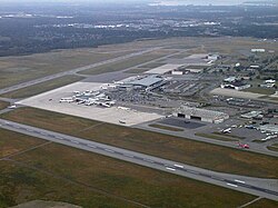
List of airports in the Ottawa area

Last updated

Newottawamap.png
Red pog.svg
CYND
Red pog.svg
CYOW
Red pog.svg
CNR6
Red pog.svg
CYRP
Red pog.svg
CPL3
Red pog.svg
CSF7
Red pog.svg
CPR2
Red pog.svg
CHF2
Red pog.svg
CYRO
Red pog.svg
CYSH
Red pog.svg
CNQ5
Red pog.svg
CTR7
Red pog.svg
CRB7
Red pog.svg
CPN7
Red pog.svg
CTA9
Red pog.svg
CPK7
Red pog.svg
CPP7
Red pog.svg
CYDH
Red pog.svg
CQH2
Red pog.svg
CWH4
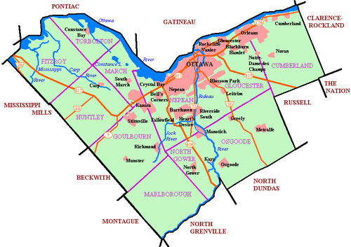
Location in the Ottawa area
Canada Ontario relief location map.jpg
Red pog.svg
Ottawa
Location in Ontario

The following active airports serve the area around Ottawa, Ontario, Canada, lying under or adjacent to Ottawa's terminal control area: [1] [2]

Contents

Land airports

Scheduled commercial airline service

Ottawa Macdonald-Cartier International Airport Ottawa Airport.jpg
Ottawa Macdonald–Cartier International Airport
Gatineau-Ottawa Executive Airport Gatineau Airport.JPG
Gatineau-Ottawa Executive Airport
Carp Airport Carp Airport 08A.JPG
Carp Airport
Kars/Rideau Valley Air Park Kars Rideau Valley Airpark 04.JPG
Kars/Rideau Valley Air Park
Airport name ICAO/TC LID/IATA LocationCoordinates
Ottawa Macdonald–Cartier International Airport CYOW (YOW) Ottawa 45°19′21″N075°40′09″W / 45.32250°N 75.66917°W / 45.32250; -75.66917 (Ottawa Macdonald-Cartier International Airport)

Other

Airport name ICAO/TC LID/IATA LocationCoordinates
Arnprior Airport CNP3 Arnprior 45°24′49″N076°21′57″W / 45.41361°N 76.36583°W / 45.41361; -76.36583 (Arnprior/South Renfrew Municipal Airport)
Carleton Place Airport CNR6 Carleton Place 45°06′14″N076°07′24″W / 45.10389°N 76.12333°W / 45.10389; -76.12333 (Carleton Place Airport)
Carp Airport CYRP (YRP) Carp 45°19′21″N076°01′20″W / 45.32250°N 76.02222°W / 45.32250; -76.02222 (Ottawa/Carp Airport)
Gatineau-Ottawa Executive Airport CYND (YND) Gatineau, Quebec 45°31′17″N075°33′51″W / 45.52139°N 75.56417°W / 45.52139; -75.56417 (Gatineau-Ottawa Executive Airport)
Kars/Rideau Valley Air Park CPL3 Kars 45°06′00″N075°38′00″W / 45.10000°N 75.63333°W / 45.10000; -75.63333 (Kars/Rideau Valley Air Park)
Ottawa/Casselman (Shea Field) Aerodrome CSF7 Casselman 45°17′59″N075°10′17″W / 45.29972°N 75.17139°W / 45.29972; -75.17139 (Ottawa/Casselman (Shea Field) Aerodrome)
Ottawa/Embrun Aerodrome CPR2 Embrun 45°14′28″N075°17′55″W / 45.24111°N 75.29861°W / 45.24111; -75.29861 (Ottawa/Embrun Aerodrome)
Ottawa/Manotick (Hope Field) Aerodrome CHF2 Manotick 45°11′26″N075°42′31″W / 45.19056°N 75.70861°W / 45.19056; -75.70861 (Ottawa/Manotick (Hope Field) Aerodrome)
Ottawa/Rockcliffe Airport CYRO (YRO) Ottawa 45°27′37″N075°38′46″W / 45.46028°N 75.64611°W / 45.46028; -75.64611 (Ottawa/Rockcliffe Airport)
Pendleton Airport CNF3 Pendleton 45°29′10″N075°05′46″W / 45.48611°N 75.09611°W / 45.48611; -75.09611 (Pendleton Airport)
Smiths Falls-Montague Airport CYSH (YSH) Smiths Falls 44°56′45″N075°56′26″W / 44.94583°N 75.94056°W / 44.94583; -75.94056 (Smiths Falls-Montague (Russ Beach) Airport)

Macdonald-Cartier handles all of the scheduled passenger service for Ottawa, in addition to a large amount of general aviation and some military traffic. The remaining airports serve almost exclusively general aviation. Macdonald-Cartier, Gatineau, Carp, Smiths Falls, and Arnprior have instrument approaches and winter maintenance for year-round, all-weather operations.

Water aerodromes

Airport name ICAO/TC LID/IATA LocationCoordinates
Arnprior Water Aerodrome CNB5 Arnprior 45°24′27″N076°21′35″W / 45.40750°N 76.35972°W / 45.40750; -76.35972 (Arnprior Water Aerodrome)
Blue Sea Lake (Outaouais Aviation) Water Aerodrome CBS6 Blue Sea Lake 46°11′47″N076°03′28″W / 46.19639°N 76.05778°W / 46.19639; -76.05778 (Blue Sea Lake (Outaouais Aviation) Water Aerodrome)
Constance Lake Water Aerodrome CNQ5Constance Lake, Ottawa 45°24′10″N075°58′32″W / 45.40278°N 75.97556°W / 45.40278; -75.97556 (Constance Lake Water Aerodrome)
Ottawa/Rockcliffe Water Aerodrome CTR7 Ottawa 45°27′47″N075°38′47″W / 45.46306°N 75.64639°W / 45.46306; -75.64639 (Ottawa/Rockcliffe Water Aerodrome)
Rivière Blanche/Cardinal Aviation Water Aerodrome CRB7 Gatineau, Quebec 45°32′51″N075°37′40″W / 45.54750°N 75.62778°W / 45.54750; -75.62778 (Rivière Blanche/Cardinal Aviation Water Aerodrome)

Heliports

Airport name ICAO/TC LID/IATA LocationCoordinates
Carleton Place (District Memorial Hospital) Heliport CPN7 Carleton Place 45°08′32″N076°08′16″W / 45.14222°N 76.13778°W / 45.14222; -76.13778 (Carleton Place (District Memorial Hospital) Heliport)
Ottawa/Gatineau (Casino) Heliport CTA9 Gatineau, Quebec 45°26′47″N075°43′35″W / 45.44639°N 75.72639°W / 45.44639; -75.72639 (Ottawa/Gatineau (Casino) Heliport)
Ottawa (Children's Hospital) Heliport CPK7 Ottawa 45°24′04″N075°39′01″W / 45.40111°N 75.65028°W / 45.40111; -75.65028 (Ottawa (Children's Hospital) Heliport)
Ottawa (Civic Hospital) Heliport CPP7 Ottawa 45°23′30″N075°43′14″W / 45.39167°N 75.72056°W / 45.39167; -75.72056 (Ottawa (Civic Hospital) Heliport)
Ottawa/Dwyer Hill Heliport CYDH Ottawa 45°07′50″N075°56′54″W / 45.13056°N 75.94833°W / 45.13056; -75.94833 (Ottawa/Dwyer Hill Heliport)
Ottawa/Questral Helicopters CQH2 Ottawa 45°17′57″N075°30′00″W / 45.29917°N 75.50000°W / 45.29917; -75.50000 (Ottawa/Questral Helicopters)
Ottawa (Winchester District Memorial Hospital) Heliport CWH4 Winchester 45°05′17″N075°21′16″W / 45.08806°N 75.35444°W / 45.08806; -75.35444 (Ottawa (Winchester District Memorial Hospital) Heliport)
Smiths Falls (Community Hospital) Heliport CNS9 Smiths Falls 44°54′26″N076°01′38″W / 44.90722°N 76.02722°W / 44.90722; -76.02722 (Smiths Falls (Community Hospital) Heliport)

See also

References

  1. Canada Flight Supplement. Effective 0901 Z 16 July 2020 to 0901Z 10 September 2020.
  2. Nav Canada 's Water Aerodrome Supplement. Effective 0901 Z 26 March 2020 to 0901Z 22 April 2021.