The village of Long Island Locks was first settled in 1833.[4] In the 1830s, a small settlement formed in the area of the newly-constructed Long Island locks on the Rideau Canal, but there was no development in the area of present-day Manotick. A post office was established in 1854.[4]
In 1859, when a bulkhead was constructed across the west branch of the Rideau River, the entrepreneur Moss Kent Dickinson and his partner Joseph Merrill Currier obtained the water rights and constructed a stone mill on the shores of the Rideau River. The flour mill, as well as a carding mill, sawmill and a bung factory, also built by Dickinson, helped spur the development of the settlement. The flour mill was purchased in 1946 by Harry Watson and renamed Watson's Mill. It survives as a working museum, with an operational grist mill.
M. K. Dickinson, Esq., established the Long Island Flouring Mills in 1860, which had the capacity of grinding one hundred barrels of flour per diem. The buildings were substantially built of stone. The saw mill, built by M. K. Dickinson, Esq., employed twelve men and turned out about two million feet of sawn lumber per annum.[4]
Dickinson House, built in 1863, was the first major building in Manotick. It served as a general store, bank, post office, and telegraph office. The Dickinson, Spratt, and Watson families, which owned and operated Watson’s Mill, used the house as their residence from 1870 to 1972. It is currently furnished to give visitors an interpretation of what the space was like when the Dickinson family was in residence. It is included amongst other architecturally-interesting and historically-significant buildings in Doors Open Ottawa, alongside Watson's Mill.[5] Open Doors Ottawa sometimes coincides with Dickinson Days, which is Manotick’s annual festival celebrating the Founder of the village.[6]
By 1866, Long Island Locks was a post village with a population of 100 of the township of Gloucester, on the Rideau Canal, seven miles from Gloucester station, on the Ottawa and Prescott railway, and 15 miles from Ottawa. The village contained two general stores and a number of mechanics. There were two church buildings here, one occupied alternately by the Presbyterian congregation and the English Church, and the other by the Wesleyan Methodists.[4]
By 1866, Manotick was a post village with a population of 100 of the township of North Gower, on the Rideau River, five miles from Kelly's station on the Ottawa and Prescott Railway, and 17 miles from Ottawa. There was excellent water power supplied by the Rideau Canal with mails tri-weekly. The Loyal Orange Lodge, No. 477, met in Orange Hall in the village on the first Friday in each month.[4]
The original St. James Anglican Church was built of wood in a Norman style in 1876 on land donated by Moss Kent Dickinson. When a larger church was built in 1985, the original style and appearance, including a Norman tower, the original stained glass windows, plaques and much of the other furnishings were maintained. The church was included with other architecturally interesting and historically-significant buildings in Doors Open Ottawa, held June 2 and 3, 2012.[5]
Manotick was host to a Royal Canadian Navy experimental ionospheric laboratory, the Radio Propagation Laboratory (RPL) on the Prescott Highway. The RPL evolved from Section 6 of the Operational Intelligence Centre (OIC/6) of the navy during World War II. It originally occupied small huts on the Prescott Highway, which from 1944 to 1947 housed a naval high-frequency radio station, operating under the call sign CFF. The station received and transmitted messages between Naval Service Headquarters, Allied Authorities, and ships at sea, and frequently intercepted enemy transmissions. A name plate now marks the site, which is located south of the Central Experimental Farm's Arboretum in Ottawa, between the Rideau Canal and the Prescott Highway.
SunTech Greenhouses LTD, a Hydroponic Greenhouse covering 2.3 acres, was constructed in 1999 on a ninety acre lot. An additional 12,000 square feet was added in the spring of 2001, bringing the greenhouse acreage to 2.5 acres. Since then, the infrastructure was increased by 1.5 acres in 2012, bringing the total greenhouse surface to 4 acres.[5]
As commercial traffic on the Rideau Canal became less important, the population in the village declined. The population in the village rebounded as Manotick came to be viewed by some as a bedroom community for Ottawa and joined the City of Ottawa in 2001.
With perceived overdevelopment of housing in the south of Ottawa, including the rapid growth of Barrhaven, Manotick strives to maintain its character and property values by carefully managing growth and by working closely with developers.
J. Edgar Hoover visited Manotick in the 1920s to see a relative, and Al Capone is said to have had business-related ties to the town.[7]
On the first Friday and Saturday of June, the people of Manotick congregate in the heart of Manotick around Dickinson Square to celebrate Dickinson Days. The festival is named after Moss Kent Dickinson, who operated Watson's Mill (then as Long Island Flouring Mill) and was responsible for founding Manotick. This spring festival, organized by local organizations such as the Kiwanis Club, the BIA, and Watson’s Mill, usually includes activities such as a parade, pancake breakfast, arts and crafts sales, wagon rides, music, dance and drama performances.[13] The celebration coincides with "Pioneer Days", organized by the staff and volunteers of Watson's Mill.
Dickinson Days usually coincides with Doors Open Ottawa, where many local buildings, such as churches and government buildings, are open to the public for one day a year.
Watson's Mill
Watson's Mill is Manotick's most recognized landmark. Its image is used as a symbol for the village. It is the only working museum in the Ottawa area and one of very few operating industrial grist mills in North America. Indeed, Watson's Mill still sells stone-ground whole wheat flour which is made on site.
Moss Kent Dickinson and Joseph Merrill Currier founded the mill as the Long Island Flouring Mills in 1860. It was one of a series of mills constructed in the area using power from the Rideau Canal. It earned its current name when it was purchased by Harry Watson in 1946. Watson was the last owner to operate the mill at an industrial level. When the Rideau Valley Conservation Authority bought the mill in 1972, it was developed into a museum.
The mill is also well known for its ghost story. The legend is that Ann Currier, wife of Joseph Currier, haunts the mill, following her death in a tragic accident[14] there in 1861.
Watson's Mill is open to the public during the summer months and hosts a variety of events, including milling demonstrations every Sunday.
Mahogany subdivision dispute
Parts of this article (those related to this section) need to be updated. Please help update this article to reflect recent events or newly available information.(January 2010)
In 2007, Minto Developments Inc. sought approval to construct a community of approximately 1800 new homes in Manotick. The number was later revised to 1400 in early 2008 through the Development Concept Plan process with the city of Ottawa and numerous public meetings and consultations with residents. The project drew concerns by residents in the area. In the opinion of some local residents, the Minto proposal went against the spirit and letter of the pre-existing Manotick's Secondary Plan. The Secondary Plan for the Village of Manotick was adopted by the City of Ottawa at amalgamation in 2001, providing for growth of only 250 houses by 2020.[15] Residents cited that the project would double Manotick's population and that the current services and infrastructure will be insufficient to handle the population explosion. Some residents were also concerned that Manotick will lose its "small town" character. Villagers want future development direction to be decided by residents and their elected officials, not developers.
On April 24, 2007, the West Manotick Community Association (WMCA) organized a town hall meeting to discuss the issue of Minto's proposed development at the Manotick Arena. The event drew over 2000 citizens concerned about preserving the rural character and scale of Manotick and to ensure any future planning accounts for the rural nature of the village. During 2007 and 2008, the City of Ottawa, the WMCA and Minto all hosted several formal and informal public meetings to demonstrate changes and evolutions to the proposed Development Concept Plans and to encourage public debate. Changes to the plan were made by the developer through the process.
In 2008, the Ottawa City Council rejected Minto's proposed development, stating that Minto's plan did not comply with the City's Official Plan for Manotick, nor its Secondary Plan. Additionally, the City claimed that the proposed development did not match the village's "rural character".[16] Minto appealed the council's decision, sending the matter to the Ontario Municipal Board ("OMB") in a seven-week hearing that ended in late January 2009. The OMB overruled the Ottawa City Council in a "controversial" decision to approve Minto's plans.[15] The City of Ottawa requested a Leave to Appeal the OMB decision, with a hearing that took place on June 25, 2009.
Ultimately, extensive cooperation between Minto and the community resulted in an approved plan for the development, and the construction now is long underway.[17]
Related Research Articles
The Rideau Canal is a 202-kilometre long canal that links the Ottawa River at Ottawa with the Cataraqui River and Lake Ontario at Kingston, Ontario, Canada. Its 46 locks raise boats from the Ottawa River 83 metres upstream along the Rideau River to the Rideau Lakes, and from there drop 50 metres downstream along the Cataraqui River to Kingston.
Old Ottawa South is an older urban neighbourhood in Capital Ward in Ottawa, Ontario, Canada. Old Ottawa South is a relatively small and compact neighbourhood, located between the Rideau Canal and the Rideau River. The eastern boundary is Avenue Road. Bronson Avenue forms the western border of the residential neighbourhood. Carleton University is on the other (western) side of Bronson but the campus can be considered to be geographically within Old Ottawa South as the campus is also nestled between the river and the canal.
Richmond is a rural village within the amalgamated City of Ottawa, Ontario, Canada. Founded in 1818, it spans the Jock River, a tributary of the Rideau River. A part of the National Capital Region, Richmond is located 10 kilometres (6.2 mi) southwest of Kanata and immediately south to the community of Stittsville.
The Regional Municipality of Ottawa–Carleton was a Regional Municipality and Census Division in Ontario, Canada, that existed between January 1, 1969, and January 1, 2001, and was primarily centred on the City of Ottawa. It was created in 1969 by restructuring Carleton County and annexing Cumberland Township from the United Counties of Prescott and Russell into the newly created Region of Ottawa–Carleton.
Barrhaven is a suburb of Ottawa, Ontario, Canada. It is located about 17 km (11 mi) southwest of the city's downtown core. Prior to amalgamation with Ottawa in 2001, Barrhaven was part of the City of Nepean. Its population as of the Canada 2021 Census was 103,234.
The Bytown and Prescott Railway (B&PR) was a railway joining Ottawa with Prescott on the Saint Lawrence River, in the Province of Canada. The company was incorporated in 1850, and the first train ran from Prescott into Bytown on Christmas Day, 1854. The 84 kilometres (52 mi) railway, Ottawa's first to outside markets, was initially used to ship lumber collected on the Ottawa River for further shipping along the St. Lawrence to markets in the United States and Montreal.
The Ontario Municipal Board (OMB) was an independent administrative board, operated as an adjudicative tribunal, in the province of Ontario, Canada. It heard applications and appeals on municipal and planning disputes, as well as other matters specified in provincial legislation. The tribunal reported to the Ministry of the Attorney General from 2012 until it was replaced in 2018. The Board had been criticized for its broad powers and authority to override the Planning Act decisions of municipal councils.
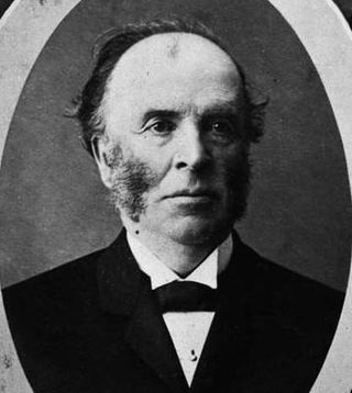
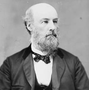
Moss Kent Dickinson was a Canadian businessman, mayor of Ottawa from 1864 to 1866, Member of Parliament from 1882 to 1887 and the founder of Manotick.
Watson's Mill is an historic flour and gristmill in Manotick, Ontario, Canada. It is the only working museum in the Ottawa area and one of the very few operating industrial grist mills in North America. Watson's Mill still sells stone-ground whole wheat flour which is made on site. The mill is also well known for its ghost Annabelle. The legend is that Ann Currier, wife of Joseph, haunts the mill, following her death in a tragic accident there in 1861. Watson's Mill is Manotick's most recognized landmark. Its image is used as a symbol for the village.
Joseph Merrill Currier was a Canadian member of parliament and businessman.
Burritts Rapids is a small village located on the Rideau River in eastern Ontario.
North Gower is a small village in eastern Ontario, originally part of North Gower Township, now part of the city of Ottawa. Surrounding communities include Richmond, Kemptville, Kars and Manotick. Public high school students in this area go to South Carleton High School in Richmond. Elementary school students go to Marlborough Public School in North Gower.
King's Highway 16, commonly referred to as Highway 16 and historically as the Prescott Highway, is a provincially maintained highway in the Canadian province of Ontario. The highway once travelled from near Prescott to Ottawa, traversing the distance between the St. Lawrence River and the Ottawa River. However, its length was truncated significantly when most of the route was twinned with a second roadway, and renumbered as Highway 416. A short stub remains through Johnstown, providing access to the Ogdensburg–Prescott International Bridge across the St. Lawrence River to Ogdensburg, New York, where New York State Route 812 continues south.
Riverside South is a suburban community in Gloucester-South Nepean Ward in the south end of the city of Ottawa, Ontario, Canada, just southwest of Ottawa Macdonald–Cartier International Airport. Prior to amalgamation in 2001, the area was located in the city of Gloucester. Its population, according to the Canada 2021 Census, was 19,802.
Kars is a village on the Rideau River within Rideau-Jock Ward in the city of Ottawa, Ontario. Prior to joining the city in 2000 it was part of Rideau Township.
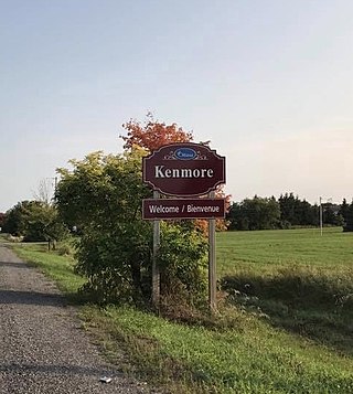
Kenmore is a rural community in Osgoode Ward in the southeastern corner of the City of Ottawa, Ontario, Canada. Prior to amalgamation in 2001, it was located in Osgoode Township. It consists of two small residential neighbourhoods and farmland. Notable features include Kenmore Bicentennial Park, Kenmore Community Centre, and the Castor River, a tributary of the South Nation River. According to the Canada 2011 Census, the population of the surrounding blocks was 501.
The architecture of Ottawa is most marked by the city's role as the national capital of Canada. This gives the city a number of monumental structures designed to represent the federal government and the nation. It also means that as a city dominated by government bureaucrats, much of its architecture tends to be formalistic and functional. However, the city is also marked by Romantic and Picturesque styles of architecture such as the Parliament Building's Gothic Revival architecture.
The history of Ottawa, capital of Canada, was shaped by events such as the construction of the Rideau Canal, the lumber industry, the choice of Ottawa as the location of Canada's capital, as well as American and European influences and interactions. By 1914, Ottawa's population had surpassed 100,000 and today it is the capital of a G7 country whose metropolitan population exceeds one million.
David Glendon Brown is a Canadian politician. He is currently the city councillor for Rideau-Jock Ward on Ottawa City Council. He was first elected in the 2022 Ottawa municipal election.
This page is based on this Wikipedia article Text is available under the CC BY-SA 4.0 license; additional terms may apply. Images, videos and audio are available under their respective licenses.