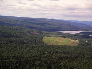
Cantung Mine is a tungsten producer in the Nahanni area of the Northwest Territories, Canada, located northeast of Watson Lake in the Flat River Valley of the Selwyn Range close to the Yukon border. Tungsten was originally discovered in the area in 1954 by prospectors. Cantung Mine operated from 1962 to 1986, again from 2002 to 2003, and from 2005. Production was suspended from October 2009 to October 2010. The mine owner, North American Tungsten Corporation, went bankrupt in 2015 and the mine closed in October of that year. The federal government of Canada now owns the mine and has to clean up the site. As of December, 2017, the mine remained closed, with the possibility of being opened to process a nearby lithium deposit.

Yellowknife Airport is located in Yellowknife, Northwest Territories, Canada. The airport is part of the National Airports System, and is operated by the Government of the Northwest Territories. The airport has regular scheduled passenger service and a number of freight services. In 2007, the terminal handled 527,000 passengers.

The Nahanni Range Road was completed in the early 1960s from Watson Lake, Yukon along the present alignment of the Robert Campbell Highway to Miner Junction, thence along the Highway 10 route, across the border into the Northwest Territories to the privately owned mining town known, confusingly, as either Cantung or Tungsten. The portion between Cantung Junction and Watson Lake has, since 1971, been part of the Robert Campbell Highway.

Diavik Airport, is a private aerodrome in the Northwest Territories, Canada that serves the Diavik Diamond Mine. It's situated in a busy area due to the closeness of Ekati Airport. Prior permission is required to land except in the case of an emergency.

Colville Lake/Tommy Kochon Aerodrome is a registered aerodrome located next to Colville Lake, Northwest Territories, Canada. A new terminal and a longer runway was opened in October 2012 and cost $12.8 million.

Wekweètì Airport, formerly known as Snare Lake Airport, is located 3.2 nautical miles east of Wekweeti, Northwest Territories, Canada.

Fort Resolution Airport is located adjacent to Fort Resolution, Northwest Territories, Canada.

Fort Liard Airport is located adjacent to Fort Liard, Northwest Territories, Canada. North Cariboo Air offers charter services from the airport.

Hay River/Merlyn Carter Airport is located 1.5 nautical miles north of Hay River, Northwest Territories, Canada. Sandhill cranes may be found nesting on the airport from May until September. The airport is named for former bush pilot Merlyn Carter who was killed by a black bear in 2005.

Ekati Airport is located at the Ekati Diamond Mine, Northwest Territories, Canada and is operated by Dominion Diamond Ekati Corp. Prior permission is required to land except in the case of an emergency. It is a busy aerodrome with blasting in the area and barren-ground caribou may be found on the runway.

The Fort Smith Airport is located near Fort Smith, Northwest Territories, Canada. Runway 03/21 has no winter service.

Déline Airport is located 1.4 nautical miles northwest of Deline, Northwest Territories, Canada. Caribou may be found on the runway. It played a role in the first episode of Arctic Air.

Wrigley Airport, is located near Wrigley, Northwest Territories, Canada.

Fort McPherson Airport is located 2 nautical miles south of Fort McPherson, Northwest Territories, Canada.
Tungsten is a chemical element with symbol W and atomic number 74.

Gahcho Kue Aerodrome is an airport located 1.4 nautical miles east southeast of the Gahcho Kue Diamond Mine Project, Northwest Territories, Canada. The airport is owned and operated by De Beers Canada and serves the Gahcho Kue Diamond Mine Project. The airport originally was an ice runway on Kennady Lake and was 5,146 ft (1,569 m) in length and numbered 08/26. The ice runway was only open from January to April.


