List of secondary highways in Algoma District

Last updated

This is a list of secondary highways in Algoma District, most of which serve as logging roads or provide access to isolated and sparsely populated areas in the Algoma District of northeastern Ontario. Some of the shorter ones are also access routes for communities with moderate amounts of tourism, most famously St. Joseph Island's highway 548.

Contents

Highway 519

Ontario Highway 519.svg

Highway 519

Route information
Maintained by the Ministry of Transportation of Ontario
Length30.5 km [1]  (19.0 mi)
Major junctions
West endOntario 17 crown.svg  Highway 17 near Obatanga Provincial Park
East end Dubreuilville
Location
Country Canada
Province Ontario
Highway system
Ontario Highway 518.svg Highway 518 Ontario Highway 520.svg Highway 520

Secondary Highway 519, commonly referred to as Highway 519, is a provincially maintained highway in the Canadian province of Ontario. The highway is 30.5 km (19.0 mi) in length, connecting Highway 17 near Obatanga Provincial Park with Dubreuilville station. A private logging road continues east from there.

Highway 519 was assumed in 1956, and has remained unchanged since then. The route is gravel surface throughout its length and encounters no communities of any size along its length, aside from Dubreuilville.

Highway 532

Ontario Highway 532.svg

Highway 532

Route information
Maintained by the Ministry of Transportation of Ontario
Length14.2 km [1]  (8.8 mi)
Existed1974[ citation needed ]–present
Major junctions
South endOntario Highway 556.svg  Highway 556 near Glendale
North endChristina Mine Road
Location
Country Canada
Province Ontario
Counties Algoma District
Towns Searchmont
Villages Wabos
Highway system
Ontario Highway 531.svg Highway 531 Ontario Highway 533.svg Highway 533

Secondary Highway 532, commonly referred to as Highway 532, is a provincially maintained secondary highway in the Canadian province of Ontario. The route connects several mining and milling towns in Unorganized Algoma District, notably Searchmont. The route is remote, ending at a mine access road 14.2 kilometres (8.8 mi) north of Highway 556, its southern terminus.

A former designation of Highway 532 travelled through Muskoka along the Parry Sound Colonization Road and was redesignated as Highway 141 in 1974. At that time, the present route was established following what was until then a segment of Highway 556. It has remained unchanged since then.

Highway 538

Ontario Highway 538.svg

Highway 538

Route information
Maintained by the Ministry of Transportation of Ontario
Length5.6 km [1]  (3.5 mi)
Existed1956–present
Major junctions
West endOntario 17 crown.svg  Highway 17 at Algoma Mills
East endOntario 17 crown.svg  Highway 17 between Algoma Mills and Pronto
Location
Country Canada
Province Ontario
Towns North Shore
Highway system
Ontario Highway 537.svg Highway 537 Ontario Highway 539.svg Highway 539

Secondary Highway 538, commonly referred to as Highway 538, is a provincially maintained highway in the Canadian province of Ontario. The highway is 5.6 kilometres (3.5 mi) in length and follows an older alignment of Highway 17 east of Blind River, between the Canadian Pacific Railway tracks and the shoreline of the North Channel of Lake Huron, while the present Highway 17 runs north of the railway tracks. The route was designated in 1956 and has remained unchanged since.

Highway 546

Ontario Highway 546.svg

Highway 546

Route information
Maintained by the Ministry of Transportation of Ontario
Length76.5 km [1]  (47.5 mi)
Major junctions
Southwest endOntario 17 crown.svg  Highway 17 at Iron Bridge
Major intersectionsOntario Highway 639.svg  Highway 639 north of Elliot Lake
Northeast endMount Lake
Location
Country Canada
Province Ontario
Towns Iron Bridge, Parkinson
Highway system
Ontario Highway 545.svg Highway 545 Ontario Highway 547.svg Highway 547

Secondary Highway 546, commonly referred to as Highway 546, is a secondary highway in the Canadian province of Ontario. Located within the Algoma District, the highway extends for 76.5 kilometres (47.5 mi) from a junction with Highway 17 at Iron Bridge to Mount Lake, 12.5 kilometres (7.8 mi) northeast of a junction with Highway 639 north of Elliot Lake.

Between the intersections with Highway 17 and Highway 639, the highway is part of the Deer Trail tourist route. From north of the intersection with Highway 554, it follows the Little White River.

Highway 547

Ontario Highway 547.svg

Highway 547

Route information
Maintained by the Ministry of Transportation of Ontario
Length5.6 km [1]  (3.5 mi)
ExistedFebruary 27, 1964 [2] –present
Major junctions
South endOntario 101 crown.svg  Highway 101 near Wawa
North endCedar Street in Hawk Junction
Location
Country Canada
Province Ontario
Counties Algoma District
Highway system
Ontario Highway 546.svg Highway 546 Ontario Highway 548.svg Highway 548

Secondary Highway 547, commonly referred to as Highway 547, is a secondary highway in the Canadian province of Ontario. Located within the Algoma District, the highway spans a distance of 5.6 kilometres (3.5 mi), connecting the community of Hawk Junction to Highway 101 near Wawa.

Highway 548

Ontario Highway 548.svg

Highway 548

Route information
Maintained by Ministry of Transportation of Ontario
Length74.6 km [1]  (46.4 mi)
Major junctions
North endOntario 17 crown.svg  Highway 17 near Desbarats
South endOntario Highway 548.svg  Highway 548 (69.1 km (42.9 mi) loop around St. Joseph Island)
Location
Country Canada
Province Ontario
Highway system
Ontario Highway 547.svg Highway 547 Ontario Highway 550.svg Highway 550

Secondary Highway 548, commonly referred to as Highway 548, is a secondary highway in the Canadian province of Ontario. Despite the route's secondary highway designation, it is the main and most important highway of St. Joseph Island. This highway consists of the Bernt Gilbertson Bridge to the island and a continuous loop route that circles the island.

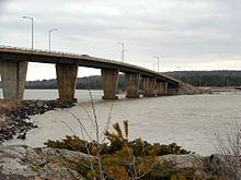
The highway connects the hamlets of Richard's Landing and Hilton Beach, and guides tourists to Fort St. Joseph. Between the bridge road and Richard's Landing, as well as along the bridge route, it is built up to King's Highway standards. The remainder of the route is built to secondary highway standards, with a single solid centerline throughout.

Termini

Highway 548 bridge to St Joseph Island St Joseph Island Bridge.jpg
Highway 548 bridge to St Joseph Island

North-South segment

  • Northern terminus: Highway 17/Trans Canada Highway.
  • Southern terminus: T-intersection with the loop segment at Kents Corners, 5.4 kilometres (3.4 mi) south of Highway 17.

Loop segment

  • Continuous loop around St. Joseph's Island for 69.1 km (42.9 mi). To aid in navigation and addressing, segments of the loop have been given suffix letters by the local municipalities, which usually correspond to the local road name. For example, the portion of Highway 548 which is signed along D Line is named 548D, along Huron Line is it named 548H, etc. [3]

Highway 550

Ontario Highway 550.svg

Highway 550

Second Line
Route information
Maintained by Ministry of Transportation of Ontario
Length11.3 km [1]  (7.0 mi)
Existed1956–present
Major junctions
West endDead end in Gros Cap, Ontario
Major intersectionsOntario Highway 565.svg  Highway 565
East endOntario 17 crown.svg  Highway 17 in Sault Ste. Marie
Location
Country Canada
Province Ontario
Major cities Sault Ste. Marie, Ontario
Highway system

Secondary Highway 550, commonly referred to as Highway 550, is a secondary highway in the Canadian province of Ontario. It runs east/west from the city of Sault Ste. Marie, Ontario to the hamlet of Gros Cap in Prince Township. It is known as Second Line within the Sault's city limits.

Its eastern terminus is an intersection with Highway 17, the Trans-Canada Highway, at the north end of the city. From here it is a four-lane undivided road, used heavily by commercial truck traffic as a link between Highway 17 and Carmen's Way, the truck bypass linking Second Line with the International Bridge. Trucks are now able to avoid the downtown core by using Highway 17, Highway 550, and Carmen's Way to reach the border with the U.S. Highway 550 reduces to two lanes west of Goulais Avenue. The highway intersects with Highway 565, also known as Airport Road. Highway 550 continues to its western terminus, at a roundabout on the shores of Lake Superior, in Gros Cap.

The MTO maintains the 9.1 km (5.7 mi) portion of Highway 550 west of Town Line Road. A 2.2 km (1.4 mi) section of Second Line between Carmen's Way and Highway 17 (Great Northern Road) is maintained under a Connecting Link agreement. The remainder, between Town Line Road and Carmen's Way, is maintained by the city of Sault Ste. Marie.

Roundabout at the western end of Hwy. 550 in Gros Cap. Gros Cap ON.JPG
Roundabout at the western end of Hwy. 550 in Gros Cap.

Highway 552

Ontario Highway 552.svg

Highway 552

Route information
Maintained by the Ministry of Transportation of Ontario
Length18.3 km [1]  (11.4 mi)
Major junctions
Southeast endOntario Highway 556.svg  Highway 556 at Island Lake
Major intersectionsOntario 17 crown.svg  Highway 17 near Karalash Corners
Northwest endGrant's Road in Goulais Bay
Location
Country Canada
Province Ontario
Counties Algoma District
Highway system
Ontario Highway 551.svg Highway 551 Ontario Highway 553.svg Highway 553

Secondary Highway 552, commonly referred to as Highway 552, is a secondary highway in the Canadian province of Ontario, located within the Algoma District. Commencing at a junction with Highway 556 in the community of Island Lake, the highway extends northwesterly for 18.3 kilometres (11.4 mi) to the community of Goulais Bay.

It passes through the communities of Kirby's Corner and Bourdage Corner, and intersects with Highway 17, the main route of the Trans-Canada Highway, just outside Karalash Corners.

Highway 552 near Island Lake Hwy 552 ON.JPG
Highway 552 near Island Lake

Highway 554

Ontario Highway 554.svg

Highway 554

Route information
Maintained by the Ministry of Transportation of Ontario
Length16.6 km [1]  (10.3 mi)
Major junctions
Northwest endOntario 129 crown.svg  Highway 129 northeast of Wharncliffe
Southeast endOntario Highway 546.svg  Highway 546 near Parkinson
Location
Country Canada
Province Ontario
Major cities Kynoch, Parkinson
Highway system
Ontario Highway 553.svg Highway 553 Ontario Highway 555.svg Highway 555

Secondary Highway 554, commonly referred to as Highway 554, is a short secondary highway in the Canadian province of Ontario. Located within the Algoma District, the highway extends for 16.6 kilometres (10.3 mi) from a junction with Highway 129 northeast of Wharncliffe to a junction with Highway 546 near Parkinson. The highway follows the valley of the Little White River for most of its length.

Highway 555

Secondary Highway 555, commonly referred to as Highway 555, is the former designation for a secondary highway in Blind River, which extended from Highway 17 to Granary Lake. The highway also had the street names Woodward Avenue in the main population centre of Blind River, and Granary Lake Road north of Highway 557.

When the route number was removed from the system in the 1990s, the portion of the route south of the Highway 557 intersection was renumbered as an extension of Highway 557. The Granary Lake Road section was entirely decommissioned from the provincial highway system, and now exists only as a local road.

In 1991, the Ministry of Transportation issued a report which proposed that the route be extended to meet Spine Road in Elliot Lake, [4] creating an alternate route which would reduce the length of a commute between Elliot Lake and Blind River by approximately 20 kilometres compared to the current routes of Highway 17 and Highway 108. [4] While the ministry has not announced a plan to proceed with the construction, in 2015 Elliot Lake's city council passed a motion calling for the project to be revived. [4]

Highway 556

Ontario Highway 556.svg

Highway 556

Searchmont Highway, Ranger Lake Road
Route information
Maintained by the Ministry of Transportation of Ontario
Length103.7 km [1]  (64.4 mi)
Major junctions
FromOntario 17 crown.svg  Highway 17 at Heyden
Major intersectionsOntario Highway 532.svg  Highway 532 near Searchmont
ToOntario 129 crown.svg  Highway 129 near Aubrey Falls
Location
Country Canada
Province Ontario
Highway system
Ontario Highway 555.svg Highway 555 Ontario Highway 557.svg Highway 557

Secondary Highway 556, commonly referred to as Highway 556 or Ranger Lake Road is a secondary highway in the province of Ontario, Canada. Its western terminus is at Highway 17 in the hamlet of Heyden, just north of Sault Ste. Marie. Its eastern terminus is at Highway 129.

It is 103.7 kilometres (64.4 mi) in length, [1] of which only 27 km (17 mi) are paved.[ citation needed ] This paved section runs from its western terminus to the intersection with Highway 532 near Searchmont and is therefore informally known as the Searchmont Highway. From this point, the highway surface is rough gravel for its remaining length. Ranger Lake is the only community on this portion of Highway 556. Despite its relatively poor surface, it is considered an alternate link between Chapleau and Sault Ste. Marie.

Hwy 556 near Island Lake Hwy 556 ON.JPG
Hwy 556 near Island Lake

Highway 557

Ontario Highway 557.svg

Highway 557

Route information
Maintained by the Ministry of Transportation of Ontario
Length19.7 km [1]  (12.2 mi)
Major junctions
South endGranary Lake Road near Blind River
(signed south to Highway 17)
North end Matinenda Lake
Location
Country Canada
Province Ontario
Counties Algoma District
Highway system
Ontario Highway 556.svg Highway 556 Ontario Highway 558.svg Highway 558

Secondary Highway 557, commonly referred to as Highway 557, is a secondary highway in the Canadian province of Ontario, located within the Algoma District. Commencing at a junction with Highway 17 in the town of Blind River, the highway extends northerly for 22.9 km (14.2 mi) to the shore of Matinenda Lake, providing the primary road access to Matinenda Lake Provincial Park as well as to rural parts of the town of Blind River and the neighbouring Mississauga First Nation. The road has the street name Woodward Avenue from Highway 17 to Granary Lake Road, and Matinenda Road west of that intersection.

Prior to the late 1990s, the Woodward Avenue segment of the highway was designated as Highway 555. The 557 designation applied only to Matinenda Road, while the 555 designation continued along Granary Lake Road. When Granary Lake Road was decommissioned from the provincial highway system, the 557 designation was extended along Woodward Avenue rather than the 555 designation being shifted from Granary to Matinenda.

The MTO does not maintain the 3.2 km (2.0 mi) section of Highway 557 south of the Granary Lake Road intersection through Blind River, [1] This section is signed as part of the highway for continuity to Highway 17.

Highway 563

Ontario Highway 563.svg

Highway 563

Route information
Maintained by Ministry of Transportation of Ontario
Length5.5 km [1]  (3.4 mi)
Major junctions
South end Batchawana Bay government dock at Lake Superior
North endOntario 17 crown.svg  Highway 17Wawa, Sault Ste. Marie
Location
Country Canada
Province Ontario
Counties Algoma District
Highway system
Ontario Highway 562.svg Highway 562 Ontario Highway 564.svg Highway 564

Secondary Highway 563, commonly referred to as Highway 563, is a secondary highway in the Canadian province of Ontario, beginning at Highway 17/Trans Canada Highway about 70 kilometres (43 mi) north of Sault Ste. Marie, and following the shoreline of Batchawana Bay. The area is a vacation spot, and Highway 563 goes through the community of the same name as the bay. Batchawana Bay has a church, post office, elementary school, motel, and homes for the permanent residents, among them First Nations people. Near the Hwy 563/17 junction is the Carp River, and there are rental cabins along the riverbank.

Highway 563 along Batchawana Bay Hwy 563 ON.JPG
Highway 563 along Batchawana Bay

Highway 565

Ontario Highway 565.svg

Highway 565

Airport Road
Route information
Maintained by Ministry of Transportation of Ontario
Length1.6 km [1]  (0.99 mi)
Major junctions
South end Prince/Sault Ste. Marie municipal boundary
North endOntario Highway 550.svg  Highway 550 in Prince
Location
Country Canada
Province Ontario
Major cities Sault Ste. Marie, Ontario
Highway system
Ontario Highway 564.svg Highway 564 Ontario Highway 566.svg Highway 566

Secondary Highway 565, commonly referred to as Highway 565, is a secondary highway in the Canadian province of Ontario, near Sault Ste. Marie. More commonly known as Airport Road, the highway is approximately 1.6 kilometres (0.99 mi) in length, shortened from its original length of 4.4 kilometres (2.7 mi) before municipal downloading. Originally, Highway 565's southern terminus was the intersection of Point-Aux-Pins Road, near the St. Mary's River. It was initially truncated at the entrance to Sault Ste. Marie Airport but now ends at Base Line, at the Sault Ste. Marie-Prince Township boundary.

Highway 631

Ontario Highway 631.png

Secondary Highway 631, commonly referred to as Highway 631, is a secondary highway in the Algoma District of Northern Ontario. This highway is roughly 167.2 kilometres (103.9 mi) in length, and connects Highway 17 at White River with Highway 11 between Hearst and Longlac.

Highway 631 is a very isolated road. There are no services available nor any development along its entire length except at Hornepayne, the only community situated on it, about 100 kilometres (60 mi) from White River.

The road was opened on May 26, 1973, costing C$7.5 million to construct. The White River terminus became a subject of brief controversy after it was rerouted to meet Highway 17 within property owned by the town's mayor, Naldo Bracci. [5]

Hwy 631 ON.jpg
"No fuel for 97 km" sign in White River
Hwy 631 ON 2.JPG
View along Hwy. 631.

Highway 638

Ontario Highway 638.svg

Highway 638

Route information
Maintained by the Ministry of Transportation of Ontario
Length52.1 km [1]  (32.4 mi)
Major junctions
Northwest endOntario 17B crown.svg  Highway 17B in Echo Bay
Major intersectionsOntario 17 crown.svg  Highway 17 in Echo Bay
Ontario Highway 670.svg  Highway 670 at Ophir
Southeast endOntario 17 crown.svg  Highway 17 in Bruce Mines
Location
Country Canada
Province Ontario
Major cities Echo Bay, Bruce Mines
Highway system
Ontario Highway 637.svg Highway 637 Ontario Highway 639.svg Highway 639

Secondary Highway 638, commonly referred to as Highway 638, is a secondary highway located in the District of Algoma in Ontario. The highway measures 52.1 kilometres (32.4 mi) in length, extending from Echo Bay eastward through the communities of Sylvan Valley, Leeburn and Ophir, where it turns southward and runs south through Rydal Bank, Bruce Station, and finally to its southeastern terminus, also at Highway 17, in the town of Bruce Mines.

Highway 638 in Rydal Bank Rydal Bank ON.JPG
Highway 638 in Rydal Bank

Highway 639

Ontario Highway 639.svg

Highway 639

Route information
Maintained by the Ministry of Transportation of Ontario
Length23.2 km [1]  (14.4 mi)
Major junctions
South endOntario 108 crown.svg  Highway 108 at Quirke Mine Road in Elliot Lake
North endOntario Highway 546.svg  Highway 546 north of Elliot Lake
Location
Country Canada
Province Ontario
Major cities Elliot Lake
Highway system
Ontario Highway 638.svg Highway 638 Ontario Highway 640.svg Highway 640

Secondary Highway 639, commonly referred to as Highway 639, is a secondary highway in the Canadian province of Ontario. Located within the Algoma District, the highway extends for 23.2 kilometres (14.4 mi) from the junction of Highway 108 and Quirke Mine Road, near the northern city limits of Elliot Lake, to a junction with Highway 546 north of the city.

The highway does not link the city to any significant residential settlements, but is used primarily as an access road to Mississagi Provincial Park and a few recreational lodges. The highway had an average daily traffic count of just 70 vehicles in 2007. [1]

The highway is a continuation of the same roadway as Highway 108, the main highway into Elliot Lake from the south. It is part of the Deer Trail tourist route. [6]

Highway 651

Ontario Highway 651.svg

Highway 651

Route information
Maintained by the Ministry of Transportation of Ontario
Length52.9 km [1]  (32.9 mi)
HistoryEstablished July 1, 1967
Extended April 30, 1969 [7]
Major junctions
South endOntario 101 crown.svg  Highway 101
North end CPR crossing in Missanabie
Location
Country Canada
Province Ontario
Districts Algoma
Highway system
Ontario Highway 650.svg Highway 650 Ontario Highway 652.svg Highway 652

Secondary Highway 651, commonly referred to as Highway 651, is a provincially maintained highway in the Canadian province of Ontario. The highway is 52.9 kilometres (32.9 mi) in length, connecting Highway 101 east of Wawa with the remote community of Missanabie.

Highway 651 was established on Centennial anniversary of Confederation, but did not connect to any other roads originally; access to the route was provided from Missanabie. While this situation has since been remedied, the route nevertheless remains extremely isolated.

Highway 670

Ontario Highway 670.svg

Highway 670

Route information
Maintained by the Ministry of Transportation of Ontario
Length9.3 km [1]  (5.8 mi)
Existed1989–present
Major junctions
West endOntario Highway 638.svg  Highway 638 at Ophir
East endNardi Road at Dunns Valley
Location
Country Canada
Province Ontario
Counties Algoma District
Highway system
Ontario Highway 668.svg Highway 668 Ontario Highway 671.svg Highway 671

Secondary Highway 670, commonly referred to as Highway 670, is a 9.3-kilometre (5.8 mi) two-lane gravel road running from Highway 638 at Ophir at its western terminus to Dunns Valley at its eastern terminus, which ends at Nardi road. At Highway 670 and Nardi Road, the roadway can continue north to Skookum lake (under a different designation), east along "The Shaw" road to Little Rapids (just north of Thessalon, Ontario) or west, down Nardi road that opens to an 800-acre farm land held within a horseshoe of mountains.

Highway 670 was established in mid- to late 1989, when a 9.5 km (5.9 mi) segment of Highway 638 between Ophir and Dunns Valley was renumbered. [8] [9]

Related Research Articles

<span class="mw-page-title-main">Algoma District</span> District in Ontario, Canada

Algoma District is a district and census division in Northeastern Ontario in the Canadian province of Ontario.

King's Highway 17, more commonly known as Highway 17, is a provincially maintained highway and the primary route of the Trans-Canada Highway through the Canadian province of Ontario. It begins at the Manitoba boundary, 50 km (31 mi) west of Kenora, and the main section ends where Highway 417 begins just west of Arnprior. A small disconnected signed section of the highway still remains within the Ottawa Region between County Road 29 and Grants Side Road. This makes it Ontario's longest highway.

<span class="mw-page-title-main">Ontario Highway 638</span> Ontario provincial highway

Secondary Highway 638, commonly referred to as Highway 638, is a provincially maintained secondary highway located in the District of Algoma in the Canadian province of Ontario. The route begins at Highway 17B in Echo Bay and travels eastward to Ophir, where it turns south to Bruce Mines, ending 1.1 km (0.7 mi) north of Highway 17. The north–south portion of the route was designated in 1956 as Highway 561. In 1962, Highway 638 was designated from Echo Bay to Highway 561, as well as a segment of the latter route from Ophir to Dunns Valley. The highway took on its current routing in 1989, assuming the route of Highway 561 south from Ophir to Bruce Mines; the section of Highway 638 from Ophir to Dunns Valley was renumbered as Highway 670.

<span class="mw-page-title-main">Ontario Highway 538</span> Ontario provincial highway

Secondary Highway 538, commonly referred to as Highway 538, is a provincially maintained highway in the Canadian province of Ontario. The highway is 5.6 kilometres (3.5 mi) in length and follows an older alignment of Highway 17 east of Blind River and near the village of Algoma Mills, between the Canadian Pacific Railway tracks and the shoreline of the North Channel of Lake Huron, while the present Highway 17 runs north of the railway tracks. The route was designated in 1956 and has remained unchanged since.

<span class="mw-page-title-main">Unorganized North Algoma District</span> Unorganized area in Ontario, Canada

Unorganized North Algoma District is an unorganized area in northeastern Ontario, Canada, comprising all areas in Algoma District, north of the Sault Ste. Marie to Elliot Lake corridor, which are not part of an incorporated municipality or a First Nation. It covers 44,077.03 km2 (17,018.24 sq mi) of land, and had a population of 6050 in 2021. Many of these communities were/are stations on the Algoma Central Railway or were logging/mining towns.

King's Highway 108, commonly referred to as Highway 108, is a provincially maintained highway in the Canadian province of Ontario. Located in the Algoma District, the highway extends for 41.6 kilometres (25.8 mi) from an intersection with Highway 17 west of Serpent River, through the urban core of Elliot Lake, to an intersection with Quirke Mine Road in the north end of the city. The highway continues as Secondary Highway 639 north of Quirke Mine Road.

King's Highway 129, commonly referred to as Highway 129, is a provincially maintained highway in the Canadian province of Ontario. Located in the Algoma and Sudbury districts, the highway extends for 221 kilometres (137 mi) from a junction with Highway 17 in Thessalon to the town of Chapleau, just north of Highway 101. The route is isolated and lightly travelled throughout its length; while providing access to several remote settlements, the only sizable communities along the route are the two termini. The highway was established in 1956 along the Chapleau Road. From the early 1960s to mid-1970s, Highway 129 was designated as the Chapleau Route of the Trans-Canada Highway.

Highway 17B was formerly the designation for six business routes of Highway 17, the main route of the Trans-Canada Highway through the Canadian province of Ontario. Each generally followed the original route of Highway 17 through the town or city that it served, and was subsequently given the Highway 17B designation when a newer bypass route was constructed to either reduce traffic pressure on the local street network, or provide a better thoroughfare that avoided urban areas altogether.

<span class="mw-page-title-main">Ontario Highway 654</span> Ontario provincial highway

Secondary Highway 654, commonly referred to as Highway 654, is a secondary highway in the Canadian province of Ontario. The highway is 23.1 kilometres (14.4 mi) in length, connecting Highway 534 south of Nipissing with Highway 11 in Callander. The route was designated in 1964, and has remained unchanged since then. It is sparsely travelled, but paved throughout its length.

<span class="mw-page-title-main">Ontario Highway 533</span> Ontario provincial highway

Secondary Highway 533, commonly referred to as Highway 533, is a provincially maintained secondary highway in the Canadian province of Ontario. The route begins in the town of Mattawa, at Highway 17, and travels north to Highway 63. Between these two junctions is a large barren expanse of wilderness with almost no habitation. Mattawa is the only community along the route. Highway 533 was assumed in 1956, along with many of the secondary highways in the province. It was later extended to Highway 63 in 1958, establishing the route as it remains today. A roundabout with Highway 17 was opened in late 2011, the first on a provincial highway in Ontario.

<span class="mw-page-title-main">Ontario Highway 810</span> Ontario provincial highway

Tertiary Highway 810, commonly referred to as Highway 810, is a provincially maintained access road, extending from Bull Lake to Richie Falls alongside the River aux Sables north of Massey. A northerly extension of Highway 553, the road was established in 1974 and has remained unchanged since then.

References

  1. 1 2 3 4 5 6 7 8 9 10 11 12 13 14 15 16 17 18 19 20 Ministry of Transportation of Ontario (2016). "Annual Average Daily Traffic (AADT) counts" . Retrieved February 1, 2021.
  2. Ontario Department of Highways (March 31, 1964). "Appendix No. 3 - Schedule of Controlled Access Highways". Annual Report (Report). p. 267.
  3. St. Joseph Island map Archived 2009-03-10 at the Wayback Machine
  4. 1 2 3 "Council considers old idea for new road" Archived 2015-09-23 at the Wayback Machine . Elliot Lake Standard , August 5, 2015.
  5. Reguly, Robert (May 29, 1973). "Queen's Park Reroutes Highway to Land Owned By Conservative". The Toronto Star. p. 1.
  6. Highway 639 at onthighways.com
  7. A.A.D.T. Traffic Volumes 1955–1969 And Traffic Collision Data 1967–1969 (Report). Department of Highways. 1970. p. 145.
  8. Transportation Capital Branch (1989). "Provincial Highways Distance Table". Provincial Highways Distance Table: King's Secondary Highways and Tertiary Roads. Ministry of Transportation of Ontario: 109, 120. ISSN   0825-5350.
  9. Ontario Road Map (Map). Cartography by Cartography Section. Ministry of Transportation. 1990–91. § O–P34.