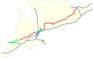
King's Highway 401, commonly referred to as Highway 401 and also known by its official name as the Macdonald–Cartier Freeway or colloquially referred to as the four-oh-one, is a controlled-access 400-series highway in the Canadian province of Ontario. It stretches 828 kilometres (514 mi) from Windsor in the west to the Ontario–Quebec border in the east. The part of Highway 401 that passes through Toronto is North America's busiest highway, and one of the widest. Together with Quebec Autoroute 20, it forms the road transportation backbone of the Quebec City–Windsor Corridor, along which over half of Canada's population resides. It is also a Core Route in the National Highway System of Canada. The route is maintained by the Ministry of Transportation of Ontario (MTO) and patrolled by the Ontario Provincial Police. The speed limit is 100 km/h (62 mph) throughout the majority of its length, with the remaining exceptions being the posted 80 km/h (50 mph) limit westbound in Windsor, in most construction zones, and the 110 km/h (68 mph) speed limit on the 40 km (25 mi) stretch between Windsor and Tilbury that was raised on April 22, 2022, the 7 km (4.3 mi) extension east of the aforementioned, the 35 km (22 mi) stretch between Highway 35 / 115 and Cobourg, the 44 km (27 mi) stretch between Colborne and Belleville, the 66 km (41 mi) stretch between Belleville and Kingston, and the 107 km (66 mi) stretch between Highway 16 and the east end of the highway that were raised on July 12, 2024.
King's Highway 407, commonly referred to as Highway 407 and colloquially as the "four-oh-seven", is a tolled 400-series highway in the Canadian province of Ontario. Comprising a privately leased segment and a publicly owned segment, the route spans the entire Greater Toronto Area (GTA) around the city of Toronto, travelling through the suburbs of Burlington, Oakville, Mississauga, Brampton, Vaughan, Markham, Pickering, Whitby, and Oshawa before ending in Clarington, north of Orono. At 151.4 km long, it is the fourth-longest expressway in Ontario's 400-series network, after Highways 417, 400, and 401. The segment between Burlington and Brougham in Pickering is leased to and operated by the 407 ETR Concession Company Limited and is officially known as the 407 Express Toll Route (407 ETR). It begins at the junction of the Queen Elizabeth Way (QEW) and Highway 403 in Burlington and travels 108.0 km (67.1 mi) across the GTA to Brock Road in Pickering. East of Brock Road, the tollway continues east as Highway 407, a toll route operated by the provincial government, for 43.4 km (27.0 mi), to Highway 35/115 in Clarington. The route interchanges with nine freeways: the QEW, Highway 403, Highway 401, Highway 410, Highway 427, Highway 400, Highway 404, Highway 412, and Highway 418. Highway 407 is an electronically operated toll highway; there are no toll booths along the route. Distances are calculated automatically using transponders or automatic number-plate recognition, which are scanned at entrance and exit portals.

The 400-series highways are a network of controlled-access highways in the Canadian province of Ontario, forming a special subset of the provincial highway system. They are analogous to the Interstate Highway System in the United States or the Autoroute system of neighbouring Quebec, and are regulated by the Ministry of Transportation of Ontario (MTO). The 400-series designations were introduced in 1952, although Ontario had been constructing divided highways for two decades prior. Initially, only Highways 400, 401 and 402 were numbered; other designations followed in the subsequent decades. To this day, not all controlled-access highways in Ontario are a part of the 400-series highway network. The network is situated almost entirely in Southern Ontario, although Highway 400 extends into the more remote northern portion of the province.

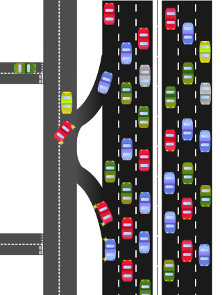
A frontage road is a local road running parallel to a higher-speed, limited-access road. A frontage road is often used to provide access to private driveways, shops, houses, industries or farms. Where parallel high-speed roads are provided as part of a major highway, these are also known as local lanes. Sometimes a similar arrangement is used for city roads; for example, the collector portion of Commonwealth Avenue in Boston, Massachusetts, is known as a carriage road.
King's Highway 427, also known as Highway 427 and colloquially as the 427, is a 400-series highway in the Canadian province of Ontario that runs from the Queen Elizabeth Way (QEW) and Gardiner Expressway in Toronto to Major Mackenzie Drive in Vaughan. It is Ontario's second busiest freeway by volume and the third busiest in North America, behind Highway 401 and Interstate 405 in California. Like Highway 401, a portion of the route is divided into a collector-express system with twelve to fourteen continuous lanes. Notable about Highway 427 are its several multi-level interchanges; the junctions with the QEW/Gardiner Expressway and Highway 401 are two of the largest interchanges in Ontario and were constructed between 1967 and 1971, while the interchanges with Highway 409 and Highway 407 were completed in 1992 and 1995, respectively.
King's Highway 409, commonly referred to as Highway 409 and historically as the Belfield Expressway, is a 400-series highway in the Canadian province of Ontario that extends from Highway 401 in Toronto to Pearson International Airport, west of Highway 427, in Mississauga. It is a short freeway used mainly as a spur route for traffic travelling to the airport or Highway 427 northbound from Highway 401 westbound, as these route movements are not accommodated at the complex interchange between Highways 401 and 427.

King's Highway 7, commonly referred to as Highway 7 and historically as the Northern Highway, is a provincially maintained highway in the Canadian province of Ontario. At its peak, Highway 7 measured 716 km (445 mi) in length, stretching from Highway 40 east of Sarnia in Southwestern Ontario to Highway 17 west of Ottawa in Eastern Ontario. However, due in part to the construction of Highways 402 and 407, the province transferred the sections of Highway 7 west of London and through the Greater Toronto Area to county and regional jurisdiction. The highway is now 535.7 km (332.9 mi) long; the western segment begins at Highway 4 north of London and extends 154.1 km (95.8 mi) to Georgetown, while the eastern segment begins at Donald Cousens Parkway in Markham and extends 381.6 km (237.1 mi) to Highway 417 in Ottawa.
The E. C. Row Expressway is a municipal expressway in the city of Windsor, Ontario, Canada. It divides the city in half as it crosses it between the Ojibway Parkway in the west and Banwell Road in the east, a distance of 15.4 kilometres (9.6 mi). It was built between 1971 and 1983, reaching completion across the city on June 9, 1983. It was part of Highway 2 and Highway 18 until the province transferred ownership and responsibility for the route to the City of Windsor on April 1, 1997. In 2015, the westernmost 3 kilometres (1.9 mi) was significantly upgraded as part of the Highway 401 extension project. The freeway is named after Edgar Charles Row, the president of Chrysler Canada between 1951 and 1956.
King's Highway 404, also known as Highway 404 and colloquially as the 404, is a 400-series highway in the Canadian province of Ontario. A continuation of the municipal Don Valley Parkway (DVP) north of Highway 401, it connects Toronto with East Gwillimbury. The 50.1-kilometre (31.1 mi) controlled-access freeway also connects with Highway 407 in Markham, which formed the northeastern ring road of the Greater Toronto Area until the opening of Highway 412 in 2016. Highway 404 provides access to the eastern edge of Richmond Hill, Aurora and Newmarket and the western edge of Whitchurch-Stouffville, in addition to the southern edge of Keswick.
King's Highway 400, commonly referred to as Highway 400, historically as the Toronto–Barrie Highway, and colloquially as the 400, is a 400-series highway in the Canadian province of Ontario linking the city of Toronto in the urban and agricultural south of the province with the scenic and sparsely populated central and northern regions. The portion of the highway between Toronto and Lake Simcoe roughly traces the route of the Toronto Carrying-Place Trail, a historic trail between the Lower and Upper Great Lakes. North of Highway 12, in combination with Highway 69, it forms a branch of the Trans-Canada Highway (TCH), the Georgian Bay Route, and is part of the highest-capacity route from southern Ontario to the Canadian West, via a connection with the mainline of the TCH in Sudbury. The highway also serves as the primary route from Toronto to southern Georgian Bay and Muskoka, areas collectively known as cottage country. The highway is patrolled by the Ontario Provincial Police and has a speed limit of 100 km/h (62 mph), except for the section south of Highway 401, where the speed limit is 80 km/h (50 mph) and the 60 km (37 mi) stretch between MacTier and Nobel, where the speed limit was raised to 110 km/h (68 mph) on April 22, 2022.
King's Highway 403, or simply Highway 403, is a 400-series highway in the Canadian province of Ontario that travels between Woodstock and Mississauga, branching off from and reuniting with Highway 401 at both ends and travelling south of it through Hamilton and Mississauga. It is concurrent with the Queen Elizabeth Way (QEW) for 22 km (14 mi) from Burlington to Oakville. The Highway 403 designation was first applied in 1963 to a short stub of freeway branching off the QEW, and the entire route was completed on August 15, 1997, when the section from Brantford to the then-still independent Town of Ancaster was opened to traffic. The section of Highway 403 between Woodstock and Burlington was formally dedicated as the Alexander Graham Bell Parkway on April 27, 2016, in honour of Alexander Graham Bell.
King's Highway 410, also known as Highway 410 and colloquially as the four-ten, is a 400-series highway in the Canadian province of Ontario that connects Highways 401 and 403 to Brampton. North of Brampton, the commuter freeway ends and the route becomes Highway 10, which continues north through Caledon as a four-lane undivided highway. The route is patrolled by the Ontario Provincial Police and has a speed limit of 100 km/h (62 mph).
King's Highway 416, commonly referred to as Highway 416 and as the Veterans Memorial Highway, is a 400-series highway in the Canadian province of Ontario that connects Highway 417 in Ottawa with Highway 401 between Brockville and Cornwall. The 76.4-kilometre-long (47.5 mi) freeway acts as an important trade corridor from Interstate 81 between New York and Eastern Ontario via Highway 401, as well as the fastest link between Ottawa and Toronto. Highway 416 passes through a largely rural area, except near its northern terminus where it enters the suburbs of Ottawa. The freeway also serves several communities along its length, notably Spencerville and Kemptville.
The Hanlon Expressway or Hanlon Parkway is a high-capacity at-grade suburban limited-access road connecting Highway 401 with the city of Guelph in the Canadian province of Ontario. The 17 km (11 mi) route travels in a generally north–south direction on the city's west side. It is signed as Highway 6 for its entire length; from Wellington Street to Woodlawn Road it is concurrent with Highway 7. The speed limit alternates between 70 and 80 km/h.

Pennsylvania Route 309 is a state highway that runs for 134 miles (216 km) through eastern Pennsylvania. The route runs from an interchange between PA 611 and Cheltenham Avenue on the border of Philadelphia and Cheltenham Township north to an intersection with PA 29 in Bowman Creek, a village in Monroe Township in Wyoming County. The highway connects Philadelphia and its northern suburbs to Allentown and the Lehigh Valley, and Hazleton and Wilkes-Barre in Wyoming Valley.
King's Highway 412, or simply Highway 412, is a controlled-access highway and former tolled highway in the Canadian province of Ontario. The route is 8.9 km (5.5 mi) long, connecting Highway 401 with the eastern extension of Highway 407. The route lies entirely within Whitby in the Regional Municipality of Durham, travelling within one kilometre of the border between Whitby and Ajax and Pickering.
King's Highway 418, or simply Highway 418, is a controlled-access highway and former tolled highway in the Canadian province of Ontario. The 400-series highway is 9.2 km (5.7 mi) long, travelling through the Regional Municipality of Durham to connect Highway 401 with the eastern extension of Highway 407. The freeway is located entirely within the Municipality of Clarington near Durham Regional Road 34.
King's Highway 35, commonly referred to as Highway 35, is a provincially maintained highway in the Canadian province of Ontario, linking Highway 401 with the Kawartha Lakes, Haliburton, and Algonquin Provincial Park. The highway travels from west of Newcastle, through Lindsay, near Fenelon Falls, Coboconk, Minden Hills, and into Haliburton before terminating at Highway 60 to the west of Algonquin Park. Within those areas, it services the communities of Orono, Cameron, Rosedale, Norland, Moore Falls, Miners Bay, Lutterworth, Carnarvon, Buttermilk Falls, Halls Lake, Pine Springs and Dorset. The winding course of the road, combined with the picturesque views offered along its length, have led some to declare it the most scenic highway in Ontario.

U.S. Route 202 is a US Highway running from New Castle, Delaware, northeast to Bangor, Maine. In the U.S. state of Pennsylvania, the route runs for 59 miles (95 km), from the Delaware state line in Bethel Township, Delaware County, to the New Hope–Lambertville Toll Bridge over the Delaware River in Solebury Township, where the route crosses into New Jersey. The highway runs through the western and northern suburbs of Philadelphia in the Delaware Valley metropolitan area, and serves as a toll-free bypass around the city, avoiding the busy traffic and congestion on Interstate 95 (I-95). It is signed north–south and follows a general southwest–northeast direction through the state.

U.S. Route 220 is a U.S. Highway that is a spur route of US 20. It runs from Rockingham, North Carolina, north to South Waverly, Pennsylvania. In the state of Pennsylvania, the route runs 248 miles (399 km) from the Maryland border in Cumberland Valley Township, Bedford County northeast to an interchange with Interstate 86 (I-86)/New York State Route 17 in South Waverly, Bradford County a short distance south of the New York border. Through the state, US 220 passes through the cities and towns of Bedford, Altoona, State College, Lock Haven, Williamsport, and Towanda. US 220 is concurrent with the entire completed Pennsylvania segment of I-99 between I-70/I-76 in Bedford and near I-80 near Bellefonte. US 220 is also a freeway around Bedford, along the I-80 concurrency between Bellefonte and Mill Hall, between Mill Hall and Jersey Shore, from the western end of Williamsport to near Halls, and near the New York border. The remainder of US 220 in Pennsylvania is mostly a two-lane surface road.


