List of secondary highways in Rainy River District

Last updated

This is a list of secondary highways in Rainy River District, most of which serve isolated and sparsely populated areas in the Rainy River District of northwestern Ontario.

Contents

Highway 502

Highway 600

Ontario Highway 600.svg

Highway 600

Route information
Maintained by Ministry of Transportation of Ontario
Length86.4 km [1]  (53.7 mi)
Major junctions
West end Rainy River north limits, north of Highway 11
Major intersectionsOntario Highway 617.svg  Highway 617
Ontario Highway 619.svg  Highway 619
Ontario Highway 621.svg  Highway 621
East endOntario 71 crown.svg  TCH-blank.svg   Highway 71  / TCH near Black Hawk
Location
Country Canada
Province Ontario
Districts Rainy River District
Towns Rainy River
Highway system
Ontario Highway 599.svg Highway 599 Ontario Highway 601.svg Highway 601

Provincial Highway 600 is a secondary highway in the Canadian province of Ontario. Its total length is 86.4 kilometres (53.7 mi). Its western terminus is Highway 11 in Rainy River, and its eastern terminus is at Highway 71. It is also one of only a few Ontario highways that are still gravel.

Highway 602

Ontario Highway 602.svg

Highway 602

Route information
Maintained by Ministry of Transportation of Ontario
Length44.6 km [1]  (27.7 mi)
Major junctions
West endOntario 11 crown.svg Ontario 71 crown.svg  TCH-blank.svg   Highway 11  / Highway 71  / TCH in Emo
Major intersectionsOntario Highway 613.svg  Highway 613
Ontario Highway 611.svg  Highway 611
East end Fort Frances west limits at Oakwood Road
Location
Country Canada
Province Ontario
Districts Rainy River District
Towns Emo, Fort Frances
Highway system
Ontario Highway 601.svg Highway 601 Ontario Highway 603.svg Highway 603

Highway 602 is a secondary highway in the Canadian province of Ontario. Its total length is 44.6 kilometres (27.7 mi). Its western terminus is Highway 11 in Emo, and its eastern terminus is at Highway 71 in Fort Frances.

Highway 611

Highway 613

Ontario Highway 613.svg

Highway 613

Route information
Maintained by Ministry of Transportation of Ontario
Length39.9 km [1]  (24.8 mi)
Major junctions
South endOntario Highway 602.svg  Highway 602 at Big Fork
Major intersectionsOntario 11 crown.svg  Highway 11
North endDead end at Lake Despair government dock near Naicatchewenin First Nation
Location
Country Canada
Province Ontario
Districts Rainy River District
Towns Big Fork, Devlin, Burriss, and Government Landing
Highway system
Ontario Highway 612.svg Highway 612 Ontario Highway 614.svg Highway 614

Secondary Highway 613 is a secondary highway in the Canadian province of Ontario. Its total length is 39.9 kilometres (24.8 mi). Its northern terminus is near Hope Lake and the Northwest Bay First Nation Reserve, and its southern terminus is at Highway 602.

Highway 615

Ontario Highway 615.svg

Highway 615

Route information
Maintained by Ministry of Transportation of Ontario
Length21.3 km [1]  (13.2 mi)
ExistedMay 9, 1956 [2] –present
Major junctions
South endOntario 71 crown.svg  TCH-blank.svg   Highway 71  / TCH near Off Lake Corner
North endDead end at Clearwater Lake
Location
Country Canada
Province Ontario
Districts Thunder Bay District
Towns Off Lake Corner, Burditt Lake
Highway system
Ontario Highway 614.svg Highway 614 Ontario Highway 617.svg Highway 617
Former provincial highways
Highway 616  

Secondary Highway 615, commonly referred to as Highway 615, is a secondary highway in the Canadian province of Ontario, located in Rainy River District. The route connects Highway 71 (the Trans-Canada Highway) with Burditt Lake and Clearwater Lake. It is 21.3 kilometres (13.2 mi) in length. [1] Highway 615 was assumed in early 1956. [3] [4]

Highway 617

Highway 619

Highway 621

Highway 622

Highway 623

Highway 633

Ontario Highway 633.svg

Highway 633

Route information
Maintained by Ministry of Transportation of Ontario
Length5.1 km [1]  (3.2 mi)
ExistedOctober 29, 1959 [5] –present
Major junctions
South endOntario 11 crown.svg  TCH-blank.svg   Highway 11  / TCH approximately 30 km (20 mi) east of Atikokan
North endDead end at Kawene flag stop
Location
Country Canada
Province Ontario
Districts Rainy River District
Towns Kawene
Highway system
Ontario Highway 632.svg Highway 632 Ontario Highway 634.svg Highway 634

Secondary Highway 633, commonly referred to as Highway 633, is a secondary highway in the Canadian province of Ontario, located in Rainy River District. The route begins at Highway 11, the Trans-Canada Highway, approximately 30 kilometres (20 mi) east of Atikokan. It travels north for 5.1 kilometres (3.2 mi) to the village of Kawene, ending at a flag stop on the Canadian National Railway.

Highway 633 was assumed by the Department of Highways, predecessor to the modern Ministry of Transportation, on October 29, 1959. [5] It has remained unchanged since then.

Related Research Articles

<span class="mw-page-title-main">Ontario Highway 638</span> Ontario provincial highway

Secondary Highway 638, commonly referred to as Highway 638, is a provincially maintained secondary highway located in the District of Algoma in the Canadian province of Ontario. The route begins at Highway 17B in Echo Bay and travels eastward to Ophir, where it turns south to Bruce Mines, ending 1.1 km (0.7 mi) north of Highway 17. The north–south portion of the route was designated in 1956 as Highway 561. In 1962, Highway 638 was designated from Echo Bay to Highway 561, as well as a segment of the latter route from Ophir to Dunns Valley. The highway took on its current routing in 1989, assuming the route of Highway 561 south from Ophir to Bruce Mines; the section of Highway 638 from Ophir to Dunns Valley was renumbered as Highway 670.
<span class="mw-page-title-main">Ontario Highway 522</span> Ontario provincial highway

Secondary Highway 522, commonly referred to as Highway 522, is a provincially maintained highway in the Canadian province of Ontario. The highway is 109.6 kilometres (68.1 mi) in length, connecting Highway 69 near Cranberry with Highway 11 at the community of Trout Creek. Highway 522 serves as the only link between these two routes south of Highway 17 and north of Highway 124. It is often used to access Grundy Lake Provincial Park, a popular camping area for northbound travellers.
<span class="mw-page-title-main">Ontario Highway 502</span> Ontario provincial highway

Secondary Highway 502, commonly referred to as Highway 502, is a provincially maintained secondary highway in the Canadian province of Ontario. The highway is 151.7 kilometres (94.3 mi) long, connecting Highway 11 east of Fort Frances with Highway 17 in Dryden, via Highway 594. It also carries the Great River Road designation.
<span class="mw-page-title-main">Ontario Highway 516</span> Ontario provincial highway

Secondary Highway 516, commonly referred to as Highway 516, is a provincially maintained secondary highway in the Canadian province of Ontario. The highway is 103.6-kilometre (64.4 mi) in length, connecting Highway 72 and Highway 642 near Sioux Lookout with Highway 599 north of Savant Lake.
<span class="mw-page-title-main">Ontario Highway 526</span> Ontario provincial highway

Secondary Highway 526, commonly referred to as Highway 526, is a provincially maintained secondary highway in the Canadian province of Ontario. It is a short and lightly travelled route that connects Highway 69 with the community of Britt.
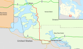
<span class="mw-page-title-main">Ontario Highway 71</span> Ontario provincial highway

King's Highway 71, commonly referred to as Highway 71, is a provincially maintained highway in the Canadian province of Ontario. The 194-kilometre-long (121 mi) route begins at the Fort Frances–International Falls International Bridge in Fort Frances, continuing from US Highway 53 (US 53) and US 71 in Minnesota, and travels west concurrently with Highway 11 for 40 kilometres (25 mi) to Chapple. At that point, Highway 11 continues west while Highway 71 branches north and travels 154 kilometres (96 mi) to a junction with Highway 17 just east of Kenora. Highway 71 forms a branch of the Trans-Canada Highway for its entire length, with the exception of the extremely short segment south of Highway 11 in Fort Frances.

King's Highway 28, commonly referred to as Highway 28, is a provincially maintained highway in the Canadian province of Ontario. The southwest–northeast route extends from Highway 7 east of Peterborough, to Highway 41 in Denbigh. The route passes over undulating hills before entering the Canadian Shield near Burleigh Falls, and gradually turns eastward.

<span class="mw-page-title-main">Ontario Highway 531</span> Ontario provincial highway

Secondary Highway 531, commonly referred to as Highway 531, is a provincially maintained secondary highway in the Canadian province of Ontario. It connects Highway 17 east of North Bay with the community of Bonfield. The 3.5-kilometre (2.2 mi) route was established in 1956, and has remained the same since then. It passes through a forested area and has several private residences located along its length. Aside from Maple Road, its southern terminus, and Highway 17, its northern terminus, Highway 531 encounters no roads along its length.

<span class="mw-page-title-main">Ontario Highway 503</span> Former Ontario provincial highway

Secondary Highway 503, commonly referred to as Highway 503, was a provincially maintained secondary highway in the Canadian province of Ontario. The 116.8 km (72.6 mi) route existed between 1956 and 1998. Between 1956 and 1963, the highway stretched from Kirkfield to Sebright, and then along the Monck Road from Sebright to Kinmount, entirely within Victoria County. In 1964, the route was extended to Highway 121 in Tory Hill along the route of Highway 500 through the counties of Peterborough and Haliburton. In 1998, the route was transferred to the various counties in which it resided. Today it is known as Kawartha Lakes City Road 6 and 45, Peterborough County Road 503 and Haliburton County Road 503.
<span class="mw-page-title-main">Ontario Highway 649</span> Former Ontario provincial highway

Secondary Highway 649, commonly referred to as Highway 649, was a provincially maintained secondary highway in the Canadian province of Ontario. Now known as Kawartha Lakes Road 49, and locally as East Street North in Bobcaygeon, it is a municipally-maintained class-3 roadway located mostly along the boundary between the city of Kawartha Lakes and Peterborough County. The 18-kilometre-long (11 mi) route begins in Bobcaygeon at a junction with former Highway 36, and proceeds north along the boundary between Kawartha Lakes and Peterborough County to a junction with former Highway 121 just south of Kinmount.

<span class="mw-page-title-main">Ontario Highway 529</span> Ontario provincial highway

Secondary Highway 529, commonly referred to as Highway 529, is a provincially maintained secondary highway in the Canadian province of Ontario. Located within Parry Sound District, the highway follows a 25.7-kilometre (16.0 mi) route, from its southern terminus at Highway 69 near Pointe au Baril to its northern terminus at the Highway 69 crossing of the Magnetawan River near Byng Inlet. Two spur routes, Highway 529A and Highway 645, branch off the highway to serve the communities of Bayfield Inlet and Byng Inlet, respectively. The route was established along the present alignment of Highway 529A in 1956. It was relocated in 1961 along the former routing of Highway 69 when a bypass opened through the area, with the former alignment being renumbered as Highway 529A.

<span class="mw-page-title-main">Ontario Highway 810</span> Ontario provincial highway

Tertiary Highway 810, commonly referred to as Highway 810, is a provincially maintained access road, extending from Bull Lake to Richie Falls alongside the River aux Sables north of Massey. A northerly extension of Highway 553, the road was established in 1974 and has remained unchanged since then.

King's Highway 70, commonly referred to as Highway 70, was a provincially maintained highway in the Canadian province of Ontario, which provided a shorter route from Highway 6 and Highway 21 in Springmount to Highway 6 in Hepworth. The route, which now forms part of Highway 6, was 15.1 kilometres (9.4 mi) long and travelled in a southeast–northwest direction west of Owen Sound. The route followed an early trail blazed by deputy surveyor Charles Rankin in 1842 that was upgraded to a modern road in the 1920s. Highway 70 was designated in 1965 and renumbered as Highway 6 in 1997. Another Highway 70 existed near Kenora between 1937 and 1959 before being renumbered as Highway 71. This designation was applied along the newly opened Heenan Highway, shortly after the Department of Highways (DHO) began numbering routes in northern Ontario. However, a series of renumberings in 1960 led to the entire length becoming part of Highway 71.

References

  1. 1 2 3 4 5 6 Ministry of Transportation of Ontario (2016). "Annual Average Daily Traffic (AADT) counts" . Retrieved February 1, 2021.
  2. Ontario Department of Highways (March 31, 1956). "Appendix No. 3 – Schedule of Assumptions of Sections of the King's Highway System for the Fiscal Year". Annual Report (Report). pp. 203, 216.
  3. Ontario Road Map (Map). Cartography by C.P. Robins. Ontario Department of Highways. 1956.
  4. "Ontario Secondary Roads Now Designated 500, 600". The Globe and Mail. Vol. 112, no. 33, 119. February 4, 1956. p. 4. Two new Ontario road numbers appear on the province's 1956 official road map which will be ready for distribution next week. The new numbers are the 500 and 600 series and designate hundreds of miles of secondary roads which are wholly maintained by the Highways Department. More than 100 secondary roads will have their own numbers and signs this year. All of these secondary roads were taken into the province's main highways system because they form important connecting links with the King's Highways
  5. 1 2 Ontario Department of Highways (March 31, 1960). "Appendix No. 3A – Schedule of Designations and Re-designations of Sections of the King's Highway and Secondary Highway Systems for the Fiscal Year Ending March 31, 1959". Annual Report (Report). pp. 237–239. Retrieved February 8, 2021.