
Actons Corners is a community in the municipality of North Grenville, United Counties of Leeds and Grenville, in eastern Ontario, Canada. An unincorporated place and compact rural community, it is located on County Road 43 between Kemptville and Merrickville at the intersection with Actons Corners Road and County Road 25.
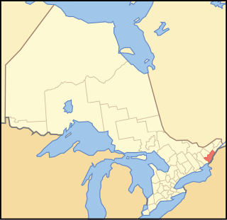
The United Counties of Leeds and Grenville, commonly known as Leeds and Grenville, is a county in Ontario, Canada, in the Eastern Ontario subregion of Southern Ontario. It fronts on the Saint Lawrence River and the international boundary between Canada and the United States, opposite of the State of New York. The county seat is Brockville. The county was formed by the union of the historical counties of Leeds and Grenville in 1850.

Bank Street is the major commercial north-south street in Ottawa, Ontario, Canada. It runs south from Wellington Street in downtown Ottawa, south through the neighbourhoods of Centretown, The Glebe, Old Ottawa South, Alta Vista, Hunt Club, and then through the villages of Blossom Park, Leitrim, South Gloucester, Greely, Metcalfe, Spring Hill, and Vernon before ending at the city limit at Belmeade Road, becoming Stormont, Dundas and Glengarry county highway 31.

Lanark County is a county located in the Canadian province of Ontario. Its county seat is Perth, which was first settled in 1816.
Area codes 613, 343, and 753 are telephone area codes in the North American Numbering Plan (NANP) for Ottawa and surrounding Eastern Ontario, Canada. Area code 613 is one of the 86 original North American area codes assigned in October 1947. Area code 343 was assigned to the numbering plan area in an overlay plan activated on May 17, 2010. Area code 753 was assigned as an additional overlay code for the numbering plan area, activated on March 26, 2022.

Eastern Ontario is a secondary region of Southern Ontario in the Canadian province of Ontario which lies in a wedge-shaped area between the Ottawa River and St. Lawrence River. It shares water boundaries with Quebec to the north and New York State to the east and south, as well as a small land boundary with the Vaudreuil-Soulanges region of Quebec to the east.

Grenville County is a former county in the Canadian province of Ontario. It fronted on the north shore of the Saint Lawrence River, between the towns of Kingston and Cornwall. The county was created in 1792, and named in honour of William Grenville, 1st Baron Grenville, who was the British Secretary of State responsible for the colonies in 1790. It consisted of five townships, which were settled primarily by United Empire Loyalists in the late 1700s after the Revolutionary War. Prior to being settled by Europeans, the area was home to many generations of native cultures. Grenville County merged with Leeds County in 1850 to create Leeds and Grenville County. The county covered an area of 272,261 acres (110,180 ha).
King's Highway 416, commonly referred to as Highway 416 and as the Veterans Memorial Highway, is a 400-series highway in the Canadian province of Ontario that connects the Trans-Canada Highway (Highway 417) in Ottawa with Highway 401 between Brockville and Cornwall. The 76.4-kilometre-long (47.5 mi) freeway acts as an important trade corridor from Interstate 81 between New York and Eastern Ontario via Highway 401, as well as the fastest link between Ottawa and Toronto. Highway 416 passes through a largely rural area, except near its northern terminus where it enters the suburbs of Ottawa. The freeway also serves several communities along its length, notably Spencerville and Kemptville.
King's Highway 138, commonly referred to as Highway 138, is a provincially maintained highway in eastern Ontario, Canada. It extends from former Highway 2 in Cornwall, north to Highway 417 east of Casselman. Highway 138 provides access to the Seaway International Bridge, connecting Cornwall with Massena, New York. The highway is 38.7 km (24.0 mi) in length.
King's Highway 34, commonly referred to as Highway 34, is a provincially maintained highway in the Canadian province of Ontario. The route connects Highway 417 south of Vankleek Hill with Hawkesbury. It is 16.9 kilometres (10.5 mi) long, traveling through a mostly rural portion of the lower Ottawa Valley near the Ontario–Quebec border. The highway formerly continued 40 kilometres (25 mi) south of Highway 417 to Highway 2 in Lancaster. However, this section was decommissioned as a provincial highway and was subsequently redesignated as Stormont, Dundas and Glengarry County Road 34.
King's Highway 16, commonly referred to as Highway 16 and historically as the Prescott Highway, is a provincially maintained highway in the Canadian province of Ontario. The highway once travelled from near Prescott to Ottawa, traversing the distance between the St. Lawrence River and the Ottawa River. However, its length was truncated significantly when most of the route was twinned with a second roadway, and renumbered as Highway 416. A short stub remains through Johnstown, providing access to the Ogdensburg–Prescott International Bridge across the St. Lawrence River to Ogdensburg, New York, where New York State Route 812 continues south.
King's Highway 31, commonly referred to as Highway 31 and historically known as the Metcalfe Road, was a provincially maintained highway in the Canadian province of Ontario. The 76.93-kilometre (47.80 mi) route connected Highway 2 in Morrisburg with the Chaudière Bridge at the Ontario–Quebec boundary in downtown Ottawa.

Kemptville Creek is a stream in the municipalities of North Grenville and Augusta, in the United Counties of Leeds and Grenville, in Eastern Ontario, Canada. It is in the Ottawa River drainage basin, is a right tributary of the Rideau River, and is under the auspices of the Rideau Valley Conservation Authority.
King's Highway 15, commonly referred to as Highway 15, is a provincially maintained highway in the Canadian province of Ontario. It travels north from an interchange with Highway 401 in Kingston to Highway 7 in Carleton Place, a distance of 114.7 kilometres (71.3 mi). In addition to Kingston and Carleton Place, the highway provides access to the Eastern Ontario communities of Joyceville, Seeley's Bay, Morton, Elgin, Crosby, Portland, Lombardy and Franktown. Prior to 1998, Highway 15 continued north from Carleton Place, passed Almonte and through Pakenham, to Highway 17 in Arnprior.
Bus companies in Ontario range in scale from small family-run businesses to subsidiaries of large international transportation groups. Many operate yellow school buses for student transportation on behalf of local school boards, while others concentrate on luxury coach charters and tours. Some municipalities use these private companies to run their public transit systems.
Black Creek in Ontario may refer to one of 37 creeks of that name:
King's Highway 32, commonly referred to as Highway 32, was a provincially maintained highway in the Canadian province of Ontario. The 19.6-kilometre (12.2 mi)-long route connected Highway 2 in Gananoque with Highway 15 east of Seeleys Bay, providing a quick alternative route between the two highways. It also featured an interchange with Highway 401. Highway 32 was assumed in 1929, and generally remained unchanged throughout its existence until 1998, when it was decommissioned and transferred to the United Counties of Leeds and Grenville. It was subsequently redesignated as Leeds and Grenville County Road 32.
King's Highway 42, commonly referred to as Highway 42, was a provincially maintained highway in the Canadian province of Ontario. The 52.8-kilometre (32.8 mi)-long route connected Highway 29 at Forthton with the town of Westport, intersecting Highway 15 en route. Highway 42 was assumed in 1935, and aside from paving the partially gravelled road, generally remained unchanged throughout its existence. In 1997, it was decommissioned and transferred to the United Counties of Leeds and Grenville, subsequently being redesignated as Leeds and Grenville County Road 42.
King's Highway 29, commonly referred to as Highway 29, was a provincially maintained highway in the Canadian province of Ontario. The 52.29-kilometre (32.49 mi) route connected Highway 2 in downtown Brockville with Highway 15 south of Smiths Falls. Between those larger settlements, it provided access to the communities of Forthton, Addison, Frankville, Toledo and Newbliss.


