This is a list of secondary highways in Cochrane District, most of which serve as logging roads, mine and dam access roads, or provide access to isolated and sparsely populated areas in the Cochrane District of northeastern Ontario.
Secondary Highway 572, commonly referred to as Highway 572, is a secondary highway in the Canadian province of Ontario which acts as a convenient short-cut for drivers travelling from Highway11/Trans Canada Highway-northbound to Highway101-eastbound, and vice versa. By taking this road, one reduces the length of their trip by 14 kilometres (8.7mi).
The road is 11 kilometres (6.8mi) in length, but before the large 1998 highway downloading spree by the province, the road continued an additional 14 kilometres (8.7mi) into Iroquois Falls, terminating at an intersection with Highway67 (which was concurrent with Highway578, another downloaded highway).
Highway 578
Highway 578 was a short spur road in Iroquois Falls that was transferred to that municipality on January1, 1998. The road served to connect Iroquois Falls to Highway11, the Trans Canada Highway, much like its sibling road, Highway577 does. The road travelled along Victoria Road in Iroquois Falls, before terminating at Anson Drive.
Secondary Highway 579, commonly referred to as Highway 579 is a secondary highway that travels north from 5th Street on the outskirts of Cochrane, north through the town of Clute to the Abitibi River, where an automobileferry allows drivers and pedestrians to cross to the town of Gardiner (its northern terminus). The road is 31.2 kilometres (19.4mi) in length, excluding a non-assumed section through Cochrane along 5th Street and 3rd Avenue to an intersection with Highway11/Trans Canada Highway and Highway652.[1]
Secondary Highway 583, commonly referred to as Highway 583, is a secondary highway in the Canadian province of Ontario. Located within Cochrane District, the highway extends from the community of Mead approximately 65 kilometres (40mi) north to Lac-Sainte-Thérèse. En route, it passes through the communities of Coppell and Jogues, and intersects with Highway11 in Hearst. The portion through the town of Hearst is not maintained by the Ministry of Transportation and separates the two halves of the highways by 9.5km (5.9mi). The portion south of Hearst to Mead is 31.1km (19.3mi) long, while the portion north of Mead to Lac-Sainte-Thérèse is 8.1km (5.0mi) long.[1]
While the highway's designation ends at Mead, the roadway continues as a lower-grade rural road, which extends for 102 kilometres to meet Highway631 at Hornepayne. A network of rural wilderness roads extending eastward from Jogues also connects the highway to Dubreuilville and portions of Missinaibi Provincial Park.
Southern terminus of highway 583 in Mead.
Highway 626
Secondary Highway 626, commonly referred to as Highway 626, was a former alignment of Highway11 in Northern Ontario. The secondary highway started in Porquis Junction at Highway67, and headed south, roughly a kilometre away from the main road, paralleling it for the entire length.
It travelled through the towns of Monteith, Val Gagné and Matheson, where it ended at Highway101. The road used to continue south all the way to Highway66 near Kirkland Lake, Ontario, but some of the pavement was removed, leaving only short dead-end streets off other roads. Highway572 currently uses a tiny portion of Highway626's former routing.
The road was transferred to local municipalities by the early 1990s. Another unrelated Highway626 existed in Algoma District for 5 years. This Highway626 ran from Highway17 south to the town of Marathon. The road leading to Marathon was designated Highway626 after the first Highway626 was deleted. The highway was downloaded in 1998 and is known today as Peninsula Road.
It is the second highway in Ontario to be named Highway634 (with the original Highway 634 being near Sudbury). Its original designation was Highway807, but was renumbered in 1977, shortly after a route renumbering. The road was re-aligned around the eastern part of Smooth Rock Falls in the mid-1990s.
Although the 2003 Ontario Official Road Map shows the road as completely paved for its entire length, the northernmost 15 kilometres (9.3mi) are gravel-surfaced. There are no gas stations on this road, aside from in Smooth Rock Falls.
As of 2019, the entire route is paved. There are no settlements of any kind along the route except for the southern terminus of Cochrane. No services are available along the route.
Secondary Highway 655, commonly referred to as Highway 655, is a secondary highway in the Cochrane District in Northern Ontario. The highway is about 75 kilometres (47mi) long. It is heavily used by trucks as a critical access road to Timmins. The highway is one of the widest (by lane width), best-maintained secondary highways in the north (more comparable to a Kings Highway), and has the distinction of being Ontario's only secondary highway that features a 90km/h (55mph) speed limit, due to its importance and high design standards.
While the highway designation ends in Calstock, the roadway continues for several more kilometres through and past the Constance Lake First Nation.
Highway 668
This section is empty. You can help by adding to it. (July 2011)
Related Research Articles
Abitibi Canyon was a community on the Abitibi River in northeastern Ontario, Canada. Abitibi Canyon was part of Northern Unorganized Cochrane District, in Cochrane District. It was located 4.0 kilometres (2.5 mi) northeast of Fraserdale.
Unorganized North Cochrane District is an unorganized area in the District of Cochrane in Northeastern Ontario, Canada. It comprises all parts of the district north of Timmins and Iroquois Falls which are not part of an incorporated municipality.
King's Highway 101, commonly referred to as Highway 101, is a provincially maintained highway in the Canadian province of Ontario. The 473.3-kilometre (294.1 mi) highway connects Highway 17 west of Wawa with Highway 11 in Matheson before continuing east to the Ontario–Quebec border where it becomes Route 388. The highway forms one of the only connections between the two routes of the Trans-Canada Highway between Nipigon and Temagami, and crosses some of the most remote regions of Northern Ontario. Major junctions are located with Highway 129 near Chapleau and Highway 144 southwest of Timmins, though the distance between these junctions is significant.
Secondary Highway 502, commonly referred to as Highway 502, is a provincially maintained secondary highway in the Canadian province of Ontario. The highway is 151.7 kilometres (94.3 mi) long, connecting Highway 11 east of Fort Frances with Highway 17 in Dryden, via Highway 594. It also carries the Great River Road designation.
Secondary Highway 520, commonly referred to as Highway 520, is a provincially maintained highway in the Canadian province of Ontario. The highway is 67.9 kilometres (42.2 mi) in length, connecting several small communities in Parry Sound District with Highway 124 and Highway 11.
Fraserdale is an unincorporated place and railroad point in Unorganized Cochrane, North Part in Cochrane District, Northern Ontario, Canada. It is located 131 kilometres (81 mi) north of Timmins along the Ontario Northland Railway. The community/train stop was named for Alan Fraser, a railway engineer, and is counted as part of Unorganized Cochrane, North Part in Canadian census data.
King's Highway 108, commonly referred to as Highway 108, is a provincially maintained highway in the Canadian province of Ontario. Located in the Algoma District, the highway extends for 41.6 kilometres (25.8 mi) from an intersection with Highway 17 west of Serpent River, through the urban core of Elliot Lake, to an intersection with Quirke Mine Road in the north end of the city. The highway continues as Secondary Highway 639 north of Quirke Mine Road.
Secondary Highway 532, commonly referred to as Highway 532, is a provincially maintained secondary highway in the Canadian province of Ontario. The route connects several mining and milling towns in Unorganized Algoma District, notably Searchmont. The route is remote, ending at a mine access road 14.2 kilometres (8.8 mi) north of Highway 556, its southern terminus.
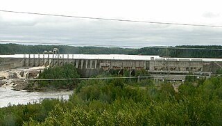
Secondary Highway 634, commonly referred to as Highway 634, is a remote highway in Northern Ontario that connects Highway 11 in Smooth Rock Falls to the Abitibi Canyon Generating Station in the community of Abitibi Canyon, Ontario. It is the second highway in Ontario to be designated Highway 634, with the original Highway 634 being near Sudbury. The current routing was at first designated as Highway 807, but was renumbered in 1977. The road was re-aligned around the eastern part of Smooth Rock Falls in the mid-1990s.
King's Highway 67, commonly referred to as Highway 67, is a provincially maintained highway in the northern portion of the Canadian province of Ontario that connects Highway 11 at Porquis Junction with the town of Iroquois Falls. The two-laned highway is 10.9 kilometres (6.8 mi) long and passes through farmland and swamps en route to the town. Highway 67 was assumed by the Department of Highways in 1937, shortly after the Department of Northern Development merged with it that year. The route originally extended south of Highway 11 to Highway 101 west of Timmins, but this portion was decommissioned as a provincial highway in 1998.
Tertiary Highway804, commonly referred to as Highway804, is a provincially maintained access road in the Canadian province of Ontario, located in Kenora District. The 21.4 kilometres (13.3 mi) route provides access to the Lower Manitou Falls Generating Station from Highway 105 near Ear Falls. Highway804 was designated in 1962 and has remained unchanged since then.
↑ "Ontario Hydro Shells Out $15,000 for 36-Hour Official Opening Party". News. The Globe and Mail. 123 (36, 385). Toronto. July 23, 1966. p.1. After a cocktail party and elaborate luncheon in the Hydro cafeteria near the Little Long station, they crowded together on the gravel surface of the new Highway 807 to watch Highways Minister Charles MacNaughton cut a red, white and blue ribbon.
↑ Ontario Department of Highways (March 31, 1965). "Appendix 21 – Schedule of designations and re-designations of sections of King's Highway, Secondary Highway and Tertiary Road Systems for the Fiscal Year Ending March 31, 1965". Annual Report (Report). pp.297–301. Retrieved February 8, 2021.
This page is based on this Wikipedia article Text is available under the CC BY-SA 4.0 license; additional terms may apply. Images, videos and audio are available under their respective licenses.