The Don Valley Parkway (DVP) is a municipal expressway in Toronto, Ontario, Canada, which connects the Gardiner Expressway in downtown Toronto with Highway 401. North of Highway 401, it continues as Highway 404. The parkway runs through the parklands of the Don River valley, after which it is named. It has a maximum speed limit of 90 km/h (56 mph) for its entire length of 15.0 km (9.3 mi). It is six lanes for most of its length, with eight lanes north of York Mills Road and four lanes south of Eastern Avenue. As a municipal road, it is patrolled by the Toronto Police Service.

U.S. Route 150 is a 571-mile (919 km) long northwest–southeast United States highway, signed as east–west. It runs from U.S. Route 6 outside of Moline, Illinois to U.S. Route 25 in Mount Vernon, Kentucky.

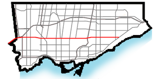
The cancelled expressways in Toronto were a planned series of expressways in Toronto, Ontario, Canada that were only partially built or cancelled due to public opposition. The system of expressways was intended to spur or handle growth in the suburbs of Toronto, but were opposed by citizens within the city of Toronto proper, citing the demolition of homes and park lands, air pollution, noise and the high cost of construction. The Spadina Expressway, planned since the 1940s, was cancelled in 1971 after being only partially constructed. After the Spadina cancellation, other expressway plans, intended to create a 'ring' around the central core, were abandoned.

Lawrence Avenue is a major east–west thoroughfare in Toronto, Ontario, Canada. It is divided into east and west portions by Yonge Street, the dividing line of east–west streets in Toronto.
Eglinton Avenue is a major east–west arterial thoroughfare in Toronto and Mississauga in the Canadian province of Ontario. The street begins at Highway 407 at the western limits of Mississauga, as a continuation of Lower Baseline in Milton. It traverses the midsection of both cities and ends at Kingston Road. Eglinton Avenue is the only street to cross all six former cities and boroughs of Metropolitan Toronto.

Kingston Road is a major arterial road in Toronto and Durham Region, Ontario. It is the southernmost major (mainly) east-west road in the eastern portion of Toronto, specifically in the district of Scarborough, and runs east to Ajax in Durham. Until 1998, it formed a portion of Highway 2. The name of the street is derived from Kingston, Ontario as the road was the primary route used to travel from Toronto to the settlements east of it situated along the shores of Lake Ontario; in the west end of Kingston, the road was referred to as the York Road until at least 1908, and is today named Princess Street.
King's Highway 48, also known as Highway 48, is a provincially maintained highway in southern Ontario that extends from Major Mackenzie Drive in Markham, through Whitchurch-Stouffville and East Gwillimbury, to Highway 12 south-east of Beaverton. The route is generally rural and straight, passing near several communities within the Regional Municipality of York. The route is 65.2 kilometres (40.5 mi) long. Most part of the road has a speed limit of 80 km/h (50 mph), except within town limits, where the speed limit is reduced to 60 km/h (37 mph) or 50 km/h (31 mph).

Brimley Road is a north-south street in Toronto and the Regional Municipality of York, Ontario, Canada. In Toronto, it is located entirely within Scarborough and carried 32000 vehicles daily in May 2007 Hence, it is classified as a major arterial road by the city of Toronto.
King's Highway 5, commonly referred to as Highway 5 and historically as the Dundas Highway and Governor's Road, is a provincially maintained highway in the Canadian province of Ontario. The east–west highway travels a distance of 12.7 km (7.9 mi) between Highway 8 at Peters Corners, north of Hamilton, and Highway 6 at Clappison's Corners. Prior to several sections being downloaded to the municipalities in which they were located, Highway 5 served as bypass to Highway 2, connecting with it in both Paris and Toronto, a distance of 114.3 km (71.0 mi).

The Golden Mile is a commercial district in the Scarborough district of Toronto, Ontario, Canada. Situated along Eglinton Avenue East, east of Victoria Park Avenue, it was one of Canada's first model industrial parks. The original Golden Mile of Industry ran along Eglinton from Pharmacy Avenue east to Birchmount Road.

Eglinton East, historically known as Knob Hill, is a residential and commercial neighbourhood in Toronto, Ontario, Canada. It is bounded by Stansbury Crescent, Citadel Drive, and West Highland Creek to the north, Midland Avenue to the west, the CNR rail line, Brimley Road, and Eglinton Avenue to the south, and Bellamy Road North to the east.
King's Highway 121, commonly referred to as Highway 121, was a provincially maintained highway in the Canadian province of Ontario that connected several communities in the cottage country region of Central Ontario on the southern edge of the Canadian Shield. Between Fenelon Falls and Minden, Highway 121 served as an alternative route to Highway 35, which was severely congested during summer weekends. From Minden, the highway branched east to Haliburton Village and thereafter followed the present route of Highway 118 to Highway 28 in Paudash.
Ontario Highway 5A (1937–1953), as a former Connecting Link in the Ontario Provincial Highway Network, bypassed portions of Ontario Highway 5 within what is now Toronto. There were two discontinuous segments:
King's Highway 11A, commonly referred to as Highway 11A, was the highway designation for an alternate route of Highway 11 in the Canadian province of Ontario. The north-south route paralleled Highway 11 within Toronto, serving as a secondary access to Downtown Toronto. It began at the York exit of the Gardiner Expressway (Highway 2) and travelled north on York Street to Front Street, where it transitioned onto University Avenue. It continued north on University Avenue to Queen's Park, where Highway 11A followed Queen's Park Crescent, encircling the Ontario Legislative Building, before continuing along Avenue Road. Highway 11A travelled along Avenue Road to Upper Canada College. It followed Lonsdale Road, Oriole Parkway, and Oxton Avenue around the campus and back to Avenue Road, which resumes north of the school. It continued north along Avenue Road to Highway 401, ending just north of the highway at Bombay Avenue.

Scarborough—Guildwood is a provincial electoral district in the Scarborough section of Toronto, Ontario, Canada, that has been represented in Legislative Assembly of Ontario since the 2007 provincial election.


.jpg)
.jpg)
.jpg)
.jpg)
.jpg)