List of secondary highways in Manitoulin District

Last updated

This is a list of secondary highways in Manitoulin District, which serve the isolated and sparsely populated areas in the Manitoulin District of Ontario.

Contents

Highway 540

Ontario Highway 540.svg

Highway 540

Route information
Maintained by Ministry of Transportation of Ontario
Length131.3 km [1]  (81.6 mi)
ExistedMay 9, 1956 [2] –present
Major junctions
West endFront Street in Meldrum Bay
Major intersectionsOntario Highway 540A.svg  Highway 540A
Ontario Highway 542.svg  Highway 542
Ontario Highway 540B.svg  Highway 540B
Ontario Highway 551.svg  Highway 551
East endOntario 6 crown.svg  Highway 6 at Little Current
Location
Country Canada
Province Ontario
Districts Manitoulin District
Towns Kagawong, Evansville
Highway system
Ontario Highway 539A.svg Highway 539A Ontario Highway 540A.svg Highway 540A

Secondary Highway 540, commonly referred to as Highway 540, is the primary eastwest secondary highway on Manitoulin Island in the Canadian province of Ontario. At 132 km (82 mi), it is the longest highway on the island. It travels from the hamlet of Meldrum Bay, near the western end of the island, to Highway 6 in the community of Little Current. Two suffixed routes branch off from Highway 540: Highway 540A extends 5.8 km (3.6 mi) from the highway onto Barrie Island; and Highway 540B, a short business spur, travels north 1.4 km (0.87 mi) to Gore Bay.


Highway 540 near Gordon. Gordon ON.JPG
Highway 540 near Gordon.

Highway 540A

Ontario Highway 540A.svg

Highway 540A

Route information
Maintained by Ministry of Transportation of Ontario
Length5.7 km [1]  (3.5 mi)
ExistedMay 9, 1956 [2] –present
Major junctions
West endBarrie Island 5th Sideroad near Gore Bay-Manitoulin Airport
East endOntario Highway 540.svg  Highway 540
Location
Country Canada
Province Ontario
Districts Manitoulin District
Towns Gordon/Barrie Island
Highway system
Ontario Highway 540.svg Highway 540 Ontario Highway 540B.svg Highway 540B

Secondary Highway 540A, commonly referred to as Highway 540A, is a secondary highway in the Canadian province of Ontario, linking Manitoulin Island with Barrie Island. It is the only road link between the two islands and has a total length of approximately 5.7 kilometres (3.5 mi).

Its western terminus is 5th Sideroad and South Line Road on Barrie Island, and its eastern terminus is at Highway 540. At the midpoint of the route, there is a junction with Airport Road, which leads to Gore Bay-Manitoulin Airport.

Highway 540B

Ontario Highway 540B.svg

Highway 540B

Route information
Maintained by Ministry of Transportation of Ontario
Length2.4 km [1]  (1.5 mi)
ExistedMay 9, 1956 [2] –present
Major junctions
FromOntario Highway 540.svg  Highway 540Little Current, Silver Water  / Poplar Road
ToOntario Highway 540.svg  Highway 540Little Current, Meldrum Bay  / Ontario Highway 542.svg  Highway 542Spring Bay
Location
Country Canada
Province Ontario
Districts Manitoulin District
Towns Gore Bay
Highway system
Ontario Highway 540A.svg Highway 540A Ontario Highway 542.svg Highway 542

Secondary Highway 540B, commonly referred to as Highway 540B, is a short secondary highway on Manitoulin Island in Northern Ontario, which serves as a business spur linking the town of Gore Bay with Highway 540.

Although many commercial map providers provide conflicting information regarding the route, the highway begins at an intersection with Highway 540 and Poplar Road. From this intersection it travels north along Range Street, and enters Gore Bay. Within the town, the highway curves east, becoming Main Street. It travels into the town, then turns south onto Meredith Street. The highway turns east onto Agnes Street and gradually curves southeast. In front of the United Hall Church, the road curves south and becomes Gore Street. After a kilometre, Gore Street curves east and becomes Wright Street. This short street ends at the boundary of Gore Bay, at which point drivers must turn south to remain on the highway, which ends at a four-way intersection with Highway 540 and Highway 542. The section within the town limits of Gore Bay is maintained under a Connecting Link agreement. [1]

Highway 542

Ontario Highway 542.svg

Highway 542

Route information
Maintained by Ministry of Transportation of Ontario
Length69.6 km [1]  (43.2 mi)
ExistedMay 9, 1956 [2] –present
Major junctions
West endOntario Highway 540.svg  Highway 540  / Ontario Highway 540B.svg  Highway 540BGore Bay, Meldrum Bay
Major intersectionsOntario Highway 551.svg  Highway 551
Ontario Highway 542A.svg  Highway 542A
East endOntario 6 crown.svg  Highway 6 near Tehkummah
Location
Country Canada
Province Ontario
Districts Manitoulin District
Towns Mindemoya, Tehkummah
Highway system
Ontario Highway 540B.svg Highway 540B Ontario Highway 542A.svg Highway 542A

Secondary Highway 542, commonly referred to as Highway 542, is a secondary highway on Manitoulin Island in the Canadian province of Ontario. It links the township of Gore Bay to Tehkummah and Highway 6. Its total length is approximately 69.6 kilometres (43.2 mi). Its western terminus is Highway 540, and before its eastern terminus is at Highway 6, near Tehkummah, it passes through the small villages of Advance, Long Bay, Britainville, Spring Bay, Dryden's Corner, Monument Corner, Central Manitoulin, Mindemoya, Gibraltar, and Sandfield.

Between Dryden's Corner and Mindemoya, Highway 542 is concurrent with Highway 551 for approximately 10.3 kilometres (6.4 mi).

Highway 542A

Ontario Highway 542A.svg

Highway 542A

Route information
Maintained by Ministry of Transportation of Ontario
Length2.4 km [1]  (1.5 mi)
ExistedMay 9, 1956 [2] –present
Major junctions
From10th Sideroad, 2nd Concession Road at Tehkummah
ToOntario Highway 542.svg  Highway 542Mindemoya, Gore Bay
Location
Country Canada
Province Ontario
Districts Manitoulin District
Major cities Tehkummah
Highway system
Ontario Highway 542.svg Highway 542 Ontario Highway 546.svg Highway 546

Secondary Highway 542A, commonly referred to as Highway 542A, is a secondary highway on Manitoulin Island in the Canadian province of Ontario. It links the township of Tehkummah to Highway 542. Its total length is approximately 2.4 kilometres (1.5 mi). Its western terminus is 10th Sideroad and Concession Road 2 in Tehkummah, and its eastern terminus is at Highway 542.

Highway 551

Ontario Highway 551.svg

Highway 551

Route information
Maintained by Ministry of Transportation of Ontario
Length28.5 km [1]  (17.7 mi)
ExistedMay 9, 1956 [2] –present
Major junctions
Southwest endGovernment Road near Providence Bay
Major intersectionsOntario Highway 542.svg  Highway 542 – 10.3 km (6.4 mi) concurrency
Mindemoya to Dryden's Corner)
Northeast endOntario Highway 540.svg  Highway 540 at M'Chigeeng First Nation
Location
Country Canada
Province Ontario
Districts Manitoulin District
Major cities Central Manitoulin
Highway system
Highway 550B Ontario Highway 552.svg Highway 552

Secondary Highway 551, commonly referred to as Highway 551, is a secondary highway in the Canadian province of Ontario. Located in Manitoulin District, the highway has a total length of 28.5 kilometres (17.7 mi).

The highway begins at a junction with Highway 540 at the M'Chigeeng First Nation, extending southerly for 11.8 kilometres (7.3 mi) to the community of Mindemoya. At Mindemoya, the highway turns westerly, sharing the routing of Highway 542 for 10.3 kilometres (6.4 mi) to the community of Dryden's Corner, where the highways split again. From Dryden's Corner, Highway 551 extends southerly a further 6.4 kilometres (4.0 mi) to its terminus at Government Road the shore of Lake Huron just outside the community of Providence Bay.

Related Research Articles

<span class="mw-page-title-main">Manitoulin Island</span> Island in Lake Huron, Ontario, Canada

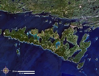
Manitoulin Island is an island in Lake Huron, located within the borders of the Canadian province of Ontario, in the bioregion known as Laurentia. With an area of 2,766 km2 (1,068 sq mi), it is the largest lake island in the world, large enough that it has over 100 lakes itself. In addition to the historic Anishinaabe and European settlement of the island, archaeological discoveries at Sheguiandah have demonstrated Paleo-Indian and Archaic cultures dating from 10,000 BC to 2,000 BC.

<span class="mw-page-title-main">Manitoulin District</span> District in Ontario, Canada

Manitoulin District is a district in Northeastern Ontario within the Canadian province of Ontario. It was created in 1888 from part of the Algoma District. The district seat is in Gore Bay.

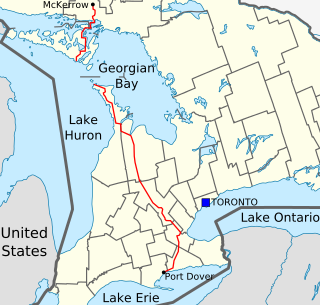
King's Highway 6, commonly referred to as Highway 6, is a provincially maintained highway in the Canadian province of Ontario. It crosses a distance of 480 km (300 mi) between Port Dover, on the northern shore of Lake Erie, and Espanola, on the northern shore of Lake Huron, before ending at the Trans-Canada Highway (Highway 17) in McKerrow.

King's Highway 60, commonly referred to as Highway 60, is a provincially maintained highway in the Canadian province of Ontario. The 255.8-kilometre (158.9 mi) highway serves as the primary corridor through Algonquin Provincial Park, where it is dedicated as the Frank McDougall Parkway. East of Algonquin Park, the route serves east–west traffic in the highlands of central Ontario. It begins at Highway 11 in Huntsville and ends at Highway 17 near Renfrew.

<span class="mw-page-title-main">Ontario Highway 538</span> Ontario provincial highway

Secondary Highway 538, commonly referred to as Highway 538, is a provincially maintained highway in the Canadian province of Ontario. The highway is 5.6 kilometres (3.5 mi) in length and follows an older alignment of Highway 17 east of Blind River and near the village of Algoma Mills, between the Canadian Pacific Railway tracks and the shoreline of the North Channel of Lake Huron, while the present Highway 17 runs north of the railway tracks. The route was designated in 1956 and has remained unchanged since.

<span class="mw-page-title-main">Ontario Highway 534</span> Ontario provincial highway

Secondary Highway 534, commonly referred to as Highway 534, is a provincially maintained secondary highway in the Canadian province of Ontario. The route begins at the entrance to Restoule Provincial Park and ends near Highway 11 in Powassan. The route provides access to several communities which lay south of Lake Nipissing. Between those communities, the highway travels mostly through thick boreal forest. It was assumed in 1956, following its present course and remaining unchanged since. It is a lightly travelled route accommodating, on an average day, no more than 830 vehicles.

King's Highway 26, commonly referred to as Highway 26, is a provincially maintained highway in the Canadian province of Ontario, connecting the cities of Owen Sound and Barrie. Between these two cities, the highway serves the southern shoreline of Georgian Bay, passing through Meaford, Collingwood and Stayner, as well as passing the Blue Mountain Resort. In addition, the highway serves as the main route to Wasaga Beach, a popular recreational destination during the summer months.

<span class="mw-page-title-main">Gore Bay, Ontario</span> Town in Ontario, Canada

]

<span class="mw-page-title-main">Central Manitoulin</span> Township in Ontario, Canada

Central Manitoulin is a township in the Canadian province of Ontario. It is located on Manitoulin Island and in Manitoulin District.

<span class="mw-page-title-main">Ontario Highway 522</span> Ontario provincial highway

Secondary Highway 522, commonly referred to as Highway 522, is a provincially maintained highway in the Canadian province of Ontario. The highway is 109.6 kilometres (68.1 mi) in length, connecting Highway 69 near Cranberry with Highway 11 at the community of Trout Creek. Highway 522 serves as the only link between these two routes south of Highway 17 and north of Highway 124. It is often used to access Grundy Lake Provincial Park, a popular camping area for northbound travellers.

<span class="mw-page-title-main">Ontario Highway 68</span> Former Ontario provincial highway

King's Highway 68, commonly referred to as Highway 68, was a provincially maintained highway on Manitoulin Island, linking the island to the mainland. It was connected to the rest of the network at McKerrow, where it met Highway 17. The road was built in the 1920s as a trunk road for the Department of Northern Development, but was assumed as a provincial highway in 1937, as the only King's Highway on the island. Highway 68 stretched from South Baymouth in the south, through the towns of Manitowaning and Little Current north through Espanola on the mainland, before terminating at Highway 17 in McKerrow.

King's Highway 63, commonly referred to as Highway 63, is a provincially maintained highway in the Canadian province of Ontario. The 63.5-kilometre (39.5 mi) route travels from Highway 11 and Highway 17 in North Bay northeast to the Ontario-Quebec provincial boundary, where it continues as Route 101 into Témiscaming.

<span class="mw-page-title-main">Ontario Highway 531</span> Ontario provincial highway

Secondary Highway 531, commonly referred to as Highway 531, is a provincially maintained secondary highway in the Canadian province of Ontario. It connects Highway 17 east of North Bay with the community of Bonfield. The 3.5-kilometre (2.2 mi) route was established in 1956, and has remained the same since then. It passes through a forested area and has several private residences located along its length. Aside from Maple Road, its southern terminus, and Highway 17, its northern terminus, Highway 531 encounters no roads along its length.

<span class="mw-page-title-main">Ontario Highway 654</span> Ontario provincial highway

Secondary Highway 654, commonly referred to as Highway 654, is a secondary highway in the Canadian province of Ontario. The highway is 23.1 kilometres (14.4 mi) in length, connecting Highway 534 south of Nipissing with Highway 11 in Callander. The route was designated in 1964, and has remained unchanged since then. It is sparsely travelled, but paved throughout its length.

References

  1. 1 2 3 4 5 6 7 Ministry of Transportation of Ontario (2016). "Annual Average Daily Traffic (AADT) counts" . Retrieved February 1, 2021.
  2. 1 2 3 4 5 6 Ontario Department of Highways (March 31, 1956). "Appendix No. 3C - Schedule of Plans Designating the King's Highways". Annual Report for the Fiscal Year (Report). p. 223.