Ontario Highway 98

Last updated

Ontario King's Highway 98.svg

King's Highway 98

Provincial Road, Middle Road, Essex County Road 46, Chatham-Kent Municipal Road 8
Ontario Highway 98
Highway 98 highlighted in red, pre-1966 routing into Windsor in blue
Route information
Maintained by Ministry of Transportation of Ontario
Length96.3 km [1]  (59.8 mi)
ExistedMarch 18, 1939 [2] –April 1, 1971. [3]
Major junctions
West endOntario 2 crown.svg  Highway 2 in Windsor
East endOntario 3 crown.svg  Highway 3 in Blenheim
Location
Country Canada
Province Ontario
Counties Essex, Chatham-Kent
Major cities Windsor, Maidstone, Woodslee, Comber, Tilbury, Merlin, Blenheim
Highway system
Ontario 94.svg Highway 94 Ontario 101.svg Highway 101
Former provincial highways
 Ontario 97.svg  Highway 97 Highway 99 Ontario 99.svg 

King's Highway 98, commonly referred to as Highway 98, was a provincially maintained highway in the Canadian province of Ontario, designated as part of the provincial highway system between 1939 and 1971. The route travelled through the northern part of Essex County and through south-central Chatham-Kent, extending 96.3 kilometres (59.8 mi) from Windsor to Blenheim. Since 1998, it has been known as Essex County Road 46 between Windsor and Tilbury, and Chatham-Kent Road 8 between Tilbury and Blenheim.

Contents

Between Windsor and Tilbury, Highway 98 followed what was the original route of Highway 2, and later Highway 2A. After being assigned a unique route number in 1939, it was extended east to Blenheim in 1941. The purpose of Highway 98 within the provincial highway network was superseded by Highway 401, which was opened in sections between Windsor and London from 1957 to 1964. Consequently, it was transferred to Essex and Kent counties in 1970 and 1971.

Route description

Highway 98 travelled from Windsor to Blenheim via Maidstone, Tilbury, Merlin and Charing Cross. [4] The former route of Highway 98 is entirely urbanised to approximately 2 km (1.2 mi) east of the Highway 401 interchange. East of that point, the highway is almost exclusively surrounded by flat farmland outside of the communities that dot its length. [5] Two conservation areas are located along the highway, both of which are maintained by the Essex Region Conservation Authority: Maidstone Conservation Area and Big O Conservation Area. It is known by various names, including Howard Avenue, Provincial Road, Middle Road and Middle Line; as well as by various designations: Essex County Road 46 and Chatham-Kent Road 8. [6]

Prior to 1966, the route began in downtown Windsor at the intersection of Ouellette Avenue and Riverside Drive. That intersection also served as the terminus for Highway 3B, Highway 18, and Highway 39; Highway 2 continued through the intersection to meet Highway 3 at the Detroit–Windsor tunnel. Highway 2, Highway 3B, Highway 39 and Highway 98 travelled southeast concurrently along Ouellette Avenue to Tecumseh Road, at which point Highway 3B branched west along that road while the others turned east. At Howard Avenue, Highway 39 continued east while Highway 2 and Highway 98 turned south. They then travelled concurrently to Cabana Road / Division Road, where Highway 2 split onto Division Road and Highway 98 onto Provincial Road. [6] [4]

Highway 98 left Windsor as it encountered an interchange with Highway 401 (Exit 14). It travelled southeast, parallel to and north of Highway 3, to Maidstone. There, the highway curved and became Middle Road. It followed this road east, travelling through the communities of Pleasant Park, North Woodslee and Ruscom Station before curving northeast and through Comber. It curved east briefly before turning back northeast and skirting the southern edge of Tilbury. At the intersection of Queen Street South and Wheatley Road it left Essex County and entered what is now the municipality of Chatham-Kent. Continuing east, now as Middle Line, the route encountered the communities of Valetta, Stewart and Merlin before curving northeast. It bisected South Buxton before encountering Charing Cross and turning east. It continued for a short distance into Blenheim, where it ended at Highway 3 (Talbot Street). [6] [4]

History

1926 highway map of Essex County, before the opening of the Ambassador Bridge Essex, Ontario Highways 1926.jpg
1926 highway map of Essex County, before the opening of the Ambassador Bridge

Predecessor

Highway 98 was first assigned in 1939 out of a route renumbering scheme. [7] However, the route it would follow was already maintained by the Department of Public Highway (DPHO), predecessor to the modern Ministry of Transportation of Ontario, as early as 1920. Although the rest of the route which later became Highway 2, from London to the Quebec boundary, was easily decided upon, the section west of London became a contentious local issue. Cities including Sarnia, St. Thomas, Leamington, Chatham, Tilbury, Windsor, and even London itself, as well as numerous road and business associations, lobbied the provincial government to take over certain roads that provided the greatest benefit to them. London and St. Thomas in particular insisted that "the Provincial Highway" follow the Longwood Road or the Talbot Road, respectively. [8] In the end, the province chose to utilise both the Longwood and Talbot roads, creating an entire network of highways in the process. [9] In April 1920, the DPHO assumed control of several roads connecting Windsor with London via Maidstone, Tilbury and Chatham as part of "the Provincial Highway". [10]

The Provincial Highway was assigned a number — Highway 2 — during the summer of 1925. [11] It travelled concurrently with the International Highway — Highway 3 — from the former ferry docks at Riverside Drive and Ouellette Avenue. It then followed Ouellette Avenue south to Tecumseh Road, where it jogged west and turned south onto Dougall Avenue, then onto Howard Avenue, and east along Talbot Road. At Maidstone, the concurrency ended, with Highway 2 branching northeast along Malden Road and east on Middle Road. [12] This arrangement remained in place until the opening of the Ambassador Bridge on November 15, 1929, which resulted in several modifications to the highway network within Essex County. [13]

Renumberings

In anticipation of the opening of the Ambassador Bridge, as well as the nearby Detroit–Windsor tunnel, Windsor and the surrounding townships sought road improvements between Windsor and Maidstone to alleviate traffic along Talbot Road and bypass or separate several level crossings of the Michigan Central Railway (MCR) beginning in early 1929. [14] [15] [16] The province chose to designate a new right-of-way adjacent to and north of the MCR in July of that year, [17] and spent the next several months constructing the cut-off (now known as Provincial Road) from Howard Avenue to north of Maidstone. [18] By 1930, Highway 2 had been rerouted to begin at the ferry docks, following Ouellette Avenue to Tecumseh Road, then east to and south along Howard Avenue; the short segment near Maidstone became Highway 2A. [19]

Facing west towards downtown Windsor along Ouellette Avenue in 1951. The sign assembly at right features reassurance markers for Highway 2, Highway 3B, Highway 39, and Highway 98. Ouellette Avenue 1951, Windsor, Ontario.png
Facing west towards downtown Windsor along Ouellette Avenue in 1951. The sign assembly at right features reassurance markers for Highway 2, Highway 3B, Highway 39, and Highway 98.

Meanwhile, the province set out to build a third highway into Windsor. Essex County had designated County Road 19 along Cabana Road (now Division Road) and Baseline Road to Tilbury on April 19, 1928, [20] and soon thereafter the DPHO promised to take over the route as a new provincial highway. [21] Highway 18 was officially designated on June 11, 1930 along the route, [22] while construction was already underway on a gentle curve between Provincial Road and the new highway, which was completed on July 14, 1931. [23] Between then and early 1932, several more changes were made to the highway system. Since the route of Highway 18 was shorter than the route of Highway 2 between Windsor and Tilbury, the newly renamed Department of Highways (DHO) renumbered Highway 18 as Highway 2 in February 1932, while the old route of Highway 2 became Highway 2A. [24] [25]

In 1939, the province instituted a change to its "numbering" policy in which lettered suffixes would only be used for short feeder routes and not for long distance routes. Consequently, Highway 2A became Highway 98 effective March 18, 1939. [2] Taking inspiration from a program first carried out in Welland County in the summer of 1931 by the Rose Highway Association, [26] [27] the Essex County Tourist Association and Essex County Automobile Club began providing rose bushes to property owners along the route at reduced costs, gaining Highway 98 the nickname "The Rose Trail". [28]

Extension, improvements and replacement

Highway 98 was extended east through Kent County to Blenheim along Kent County Road 8 on April 30, 1941, increasing its length by 39.0 km (24.2 mi). [29] The short section of Highway 98 along Queen Street through Tilbury was redesignated as Highway 98B, but was never signed as such. [30] Initially, the new section of Highway 98 was paved through the village of Merlin as well as between Charing Cross and Blenheim, while the remainder was gravel-surfaced. [31] Paving operations resumed following World War II, with the section between Merlin and Charing Cross being paved in 1946. [32] The last remaining gravel section, between Tilbury and Merlin, was paved in 1950. [33]

Aerial view of Highway 401 facing southwest in 1958. The interchange with Highway 98 is in the foreground, and the split at Dougall Parkway in the background. Highway 401 at Highway 98 facing southwest towards Windsor.png
Aerial view of Highway 401 facing southwest in 1958. The interchange with Highway 98 is in the foreground, and the split at Dougall Parkway in the background.

Construction of Highway 401 in the Essex county began in the early 1950s, with the new "superhighway" opening in segments as it was completed. While the section from Highway 98 to west of Tilbury was opened on August 15, 1957, [34] steel shortages would delay the completion of the entrances into Windsor until June 9, 1958. [35] [36] A bypass around Tilbury opened November 20, 1961. [37] East of Tilbury, the highway was opened one carriageway at a time; the westbound lanes opened to Highway 21 on September 20, 1963, [38] while the eastbound lanes opened as far east as Bloomfield Road south of Chatham on September 17, 1964, [39] and several months later to the Kent County boundary on December 7. [40]

Following the completion of Highway 401, the DHO commissioned the Southwestern Ontario Highway Planning Study, which was completed in July 1966. It examined traffic patterns and determined ideal travel lines and redundant routes. The new freeway had shifted the majority of long-distance traffic onto it, and severely reduced volume on parallel routes (Highways 2, 3, 39, 18, and 98). Accordingly, the DHO sought to divest itself of the costs of maintaining these roads. [41] [42] The portion of Highway 98 east of Tilbury was transferred to Kent County on May 21, 1970, in exchange for the DHO assuming Highway 40 between Chatham and Blenheim. [43] [44] The portion between Windsor and Tilbury was supposed to be transferred to Essex County on June 1, 1970, [30] but was delayed until April 1, 1971. [45] This removed Highway 98 from the provincial highway system entirely. The former highway has since been known as Essex County Road 46 west of Tilbury, and Kent County Road 8 or Chatham-Kent Municipal Road 8 east of Tilbury. [44] [46]

Major intersections

The following table lists the major junctions along Highway 98, as noted by the Ministry of Transportation of Ontario.Distances in this table were calculated using Google Earth 

DivisionLocationkmmiDestinationsNotes
Essex Windsor 0.00.0Ontario 2 crown.svg Ontario 18 crown.svg  Highway 2  / Highway 18 west (Riverside Drive)Beginning of concurrency with Highway 2, Highway 3B and Highway 39
2.91.8Ontario 3B crown.svg  Highway 3B west (Tecumseh Road)End of Highway 3B concurrency; Highway 2, Highway 39 and Highway 98 turned east onto Tecumseh Road
3.62.2Ontario 2 crown.svg  Highway 2 south (Howard Avenue)
Ontario 39 crown.svg  Highway 39 east (Tecumseh Road)
End of Highway 39 concurrency; Highway 2 and Highway 98 turned south onto Howard Avenue
6.64.1Howard Avenue / Division Street split
8.0–
8.9
5.0–
5.5
Division Street / Provincial Road Split
Cabana Road
End of Highway 2 concurrency; Highway 98 followed Provincial Road
10.96.8Walker Road
East Sandwich 11.47.1Ontario 401 crown.svg  Highway 401 Exit 14
14.79.1Highway 98 became North Talbot Road
Maidstone 19.011.8RR 19 jct.svg  County Road 19 (Manning Road)Highway 98 became Middle Road
Woodslee 32.220.0RR 27 jct.svg  County Road 27 (Belle River Road) – Belle River
Comber 46.028.6Ontario 77 crown.svg  Highway 77Leamington
Chatham-Kent Tilbury 56.535.1Highway 98B (Queen Street South)
RR 1 jct.svg Municipal Road 1 (Wheatley Road)
Stewart 68.042.3RR 14 jct.svg Municipal Road 14 (Port Road)
Merlin 73.545.7RR 7 jct.svg Municipal Road 7 (Merlin Road)
South Buxton 79.049.1RR 6 jct.svg Municipal Road 6 (A.D. Shadd Road)
Charing Cross 88.555.0RR 10 jct.svg Municipal Road 10 (Charign Cross Road) – Chatham
Blenheim 96.660.0Ontario 3 crown.svg  Highway 3 (Talbot Street West)
1.000 mi = 1.609 km; 1.000 km = 0.621 mi

See also

Related Research Articles

<span class="mw-page-title-main">Chatham-Kent</span> Municipality in Ontario, Canada

Chatham-Kent is a single-tier municipality in Southwestern Ontario, Canada. Mostly rural, its population centres are Chatham, Wallaceburg, Tilbury, Blenheim, Ridgetown, Wheatley and Dresden. The current Municipality of Chatham-Kent was created in 1998 by the amalgamation of Blenheim, Bothwell, Camden, city of Chatham, township of Chatham, Dover, Dresden, Erie Beach, Erieau, Harwich, Highgate, Howard, Orford, Raleigh, Ridgetown, Duart, Thamesville, Tilbury East, Tilbury, Wallaceburg, Wheatley and Zone.

<span class="mw-page-title-main">Lakeshore, Ontario</span> Town in Ontario, Canada

Lakeshore is a municipality on Lake St. Clair, in Essex County, Ontario, Canada. It was incorporated in 1999 by amalgamating the Town of Belle River with the townships of Maidstone, Rochester, Tilbury North, and Tilbury West. It is the largest and the most populous municipality within Essex County. However, it is part of the Windsor census metropolitan area.

<span class="mw-page-title-main">Ontario Highway 3</span> Ontario provincial highway

King's Highway 3, commonly referred to as Highway 3, is a provincially maintained highway in the Canadian province of Ontario which travels parallel to the northern shoreline of Lake Erie. It has three segments, the first of which travels from the Ambassador Bridge in Windsor to Highway 77 in Leamington. The second portion begins at Talbotville Royal outside of St. Thomas at Highway 4, and travels to the western city limits of Port Colborne. The road is regionally maintained within Port Colborne as Niagara Regional Road 3, but regains its provincial designation at Highway 140. Its third and final terminus is at Edgewood Park, within the Fort Erie town limits. From there, the road continues as Niagara Regional Road 3 to the Peace Bridge, where drivers can cross to the United States. The total length of Highway 3 is 258.2 km (160.4 mi), consisting of 49.2 km (30.6 mi) from Windsor to Leamington, 187.9 km (116.8 mi) from Talbotville Royal to Port Colborne and 21.1 km (13.1 mi) from Port Colborne to Edgewood Park.

<span class="mw-page-title-main">Ontario Highway 2</span> Former Ontario provincial highway

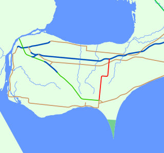
King's Highway 2, commonly referred to as Highway 2, is the lowest-numbered provincially maintained highway in the Canadian province of Ontario, and was originally part of a series of identically numbered highways which started in Windsor, stretched through Quebec and New Brunswick, and ended in Halifax, Nova Scotia. Prior to the 1990s, Highway 2 travelled through many of the major cities in Southern Ontario, including Windsor, Chatham, London, Brantford, Hamilton, Burlington, Mississauga, Toronto, Oshawa, Belleville, Kingston and Cornwall, amongst many other smaller towns and communities.

Highbury Avenue is an arterial road located in the Canadian province of Ontario. In addition to serving as a primary north–south thoroughfare in eastern London – through which part of it is a limited-access freeway – the road also provides access to Highway 401 and continues south to St. Thomas. The southern terminus of Highbury Avenue is an intersection with South Edgeware Road, just north of Highway 3 and the eastern end of the St. Thomas Expressway. From there, it travels 45.6 kilometres (28.3 mi) north to Highway 7, east of Elginfield. Outside of London and St. Thomas, the road also passes through the communities of Ballymote and Bryanston. It is designated as Elgin County Road 30 within Central Elgin, and as Middlesex County Road 23 within Middlesex Centre, the two rural municipalities through which the route passes.
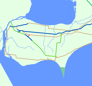
King's Highway 2A, commonly referred to as Highway 2A, was the designation of five separate provincially maintained highways in the Canadian province of Ontario. Highway 2A was an alternate route to Highway 2 in Chatham, London and Cornwall; these routes were all eventually redesignated. Highway 2A was also a highway that extended from Windsor to Tilbury, which was redesignated as Highway 98 in 1938.

<span class="mw-page-title-main">Tilbury, Ontario</span> Unincorporated community in Ontario, Canada

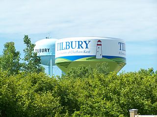
Tilbury is a community within the municipality of Chatham-Kent, Ontario, Canada. It is located 26.5 kilometres (16.5 mi) southwest of Chatham-Kent and 57.3 kilometres (35.6 mi) east of Windsor on Highway 401.

The Thousand Islands Parkway (often written as 1000 Islands Parkway) is a scenic parkway in the Canadian province of Ontario. It extends easterly from an interchange with Highway 401 in Gananoque for approximately 40 kilometres (25 mi) to rejoin Highway 401 near the community of Butternut Bay, west of Brockville. The parkway follows the north shore of the St. Lawrence River, and was formerly designated Highway 2S (S for Scenic) until 1970. It passes through the communities of Gray's Beach, Halsteads Bay, Ivy Lea, Darlingside, Rockport, Narrows, La Rue Mills and Mallorytown Landing, as well as providing access to the three inland properties of the Thousand Islands National Park. Highway 137, which meets the parkway near its midpoint, provides access to the Interstate 81 in New York via the Thousand Islands Bridge.

The St. Clair Parkway, historically referred to as the River Road, is a scenic parkway in the Canadian province of Ontario. It travels alongside the St. Clair River from west of Wallaceburg to Sarnia, a distance of 41.8 kilometres (26.0 mi). It formed a portion of the route of Highway 40 until it was bypassed by an inland route that opened in the mid-1970s. The St. Clair River Parkway Commission maintained the route from 1966 until 2006, when it was disbanded and responsibility over the parkway transferred to Chatham-Kent and Lambton County, both of which designate the route as County Road 33. The communities of Port Lambton, Sombra, Courtright, Mooretown, Corunna and Froomfield are located along the parkway, all early settlements of the 19th century.

King's Highway 40, commonly referred to as Highway 40, is a provincially maintained highway in the southwestern portion of the Canadian province of Ontario. The 91.4-kilometre (56.8 mi) route links Chatham and Sarnia via Wallaceburg, following close to the St. Clair River. The southern terminus is at Highway 401 south of Chatham, while the northern terminus is at Highway 402 in Sarnia. The portion of Highway 40 between Highway 401 and north of Wallaceburg is within the municipality of Chatham-Kent, while the portion north of there is within Lambton County.

<span class="mw-page-title-main">Ontario Highway 77</span> Ontario provincial highway

King's Highway 77, commonly referred to as Highway 77, is a provincially maintained highway in the Canadian province of Ontario. One of three highways within Essex County, Highway 77 serves to interconnect Highway 3 near Leamington with Highway 401 near Tilbury. Prior to 1998, the highway extended south into Leamington, ending at the former routing of Highway 3 and Highway 18. This section was turned over to Essex County and renamed Erie Street. The speed limit on Highway 77 is 80 km/h (50 mph) in most places, dropping to 50 km/h in built-up areas. It is patrolled by the Ontario Provincial Police.

King's Highway 39, commonly referred to as Highway 39, was a provincially maintained highway in the Canadian province of Ontario. The 33.8-kilometre (21.0 mi)-long route connected Highway 3 in downtown Windsor with Highway 2 south of Belle River, travelling along the southern shoreline of Lake St. Clair. Highway 39 was established in 1934. By 1961, the Pike Creek Bypass was opened and Highway 39 was rerouted along it, with the former route briefly becoming Highway 39B. The route was renumbered as Highway 2 in 1970, retiring the designation from the provincial highway system. Highway 2 was itself decommissioned along the former route of Highway 39 on January 1, 1998, and transferred to Essex County and the City of Windsor. It was subsequently redesignated as Essex County Road 22.

<span class="mw-page-title-main">Ontario Highway 114</span> Former Ontario provincial highway

King's Highway 114, commonly referred to as Highway 114, was a provincially maintained highway in the Canadian province of Ontario. It was one of the shortest highways ever assigned in the province, at just 1.8 kilometres (1.1 mi) in length. The route followed Malden Road for its entire length between Highway 3 and Highway 98. Part of the original provincial highway network created in 1920, Highway 114 was created in 1953 out of a route renumbering. Prior to 1953, it had been numbered Highway 2A from 1929 until 1931, Highway 3A from 1931 until 1938, and Highway 98A from 1938 until 1953. Today, Malden Road is an unnumbered local road.

<span class="mw-page-title-main">Ontario Highway 18</span> Former Ontario provincial highway

King's Highway 18, commonly referred to as Highway 18, was a provincially maintained highway in the Canadian province of Ontario, located entirely within Essex County. Since 1998, the majority of the former route has been known as Essex County Road 20. The route travelled at the southernmost point in Canada, along or near the shoreline of the Detroit River and Lake Erie between Windsor and Leamington, with Highway 3 as the terminus at both ends. The former route provides access to the communities of LaSalle, Amherstburg, Malden Centre, Harrow, Kingsville and Union.

<span class="mw-page-title-main">Ontario Highway 18A</span> Former Ontario provincial highway

King's Highway 18A, commonly referred to as Highway 18A, was a provincially maintained highway in the Canadian province of Ontario. The 31.1-kilometre-long (19.3 mi) route began and ended at Highway 18, travelling along the Lake Erie shoreline and through Colchester. It was the southernmost highway to ever exist in Canada, as the only one to travel south of the 42nd parallel. Highway 18A was assumed as a provincial highway in 1938. It was transferred to Essex County in 1978, and has since been known as Essex County Road 50.

King's Highway 15, commonly referred to as Highway 15, is a provincially maintained highway in the Canadian province of Ontario. It travels north from an interchange with Highway 401 in Kingston to Highway 7 in Carleton Place, a distance of 114.7 kilometres (71.3 mi). In addition to Kingston and Carleton Place, the highway provides access to the Eastern Ontario communities of Joyceville, Seeley's Bay, Morton, Elgin, Crosby, Portland, Lombardy and Franktown. Prior to 1998, Highway 15 continued north from Carleton Place, passed Almonte and through Pakenham, to Highway 17 in Arnprior.

King's Highway 49, commonly referred to as Highway 49, is a provincially maintained highway in the Canadian province of Ontario. The 5.8-kilometre (3.6 mi) highway travels across the Quinte Skyway and through the Tyendinaga Mohawk Territory south of Marysville.

King's Highway 22, commonly referred to as Highway 22, was a provincially maintained highway in the Canadian province of Ontario, located between Sarnia and London. Since 1998, the majority of the former route has been known as Middlesex County Road 22 and Lambton County Road 22. It began at Highway 7 and Highway 79 north of Watford and proceeded 46.0 kilometres (28.6 mi) east to Highway 4 in the north end of London. Between those two points, it passed through the small communities of Wisbeach, Dejong, Adelaide, Wrightmans Corners, Hickory Corner, Poplar Hill, Lobo, and Melrose. The highway was located within Lambton County, Middlesex County, and the city of London, and it followed the historic Egremont Road

King's Highway 78, commonly referred to as Highway 78, was a provincially maintained highway in the Canadian province of Ontario. The 17.60-kilometre (10.94 mi) route connected Highway 40 in downtown Wallaceburg with Highway 21 in Dresden.

References

  1. Ontario Road Map (Map). Cartography by C.P. Robins. Ontario Department of Highways. 1962. § Mileage Tables - The King's Highways.
  2. 1 2 Staff (March 18, 1939). "Changes Made on Highways: Get New Numbers - No. 2-A Becomes 98 Under New System". The Windsor Star. p. 6. Retrieved January 4, 2021 via Newspapers.com. Open Access logo PLoS transparent.svg
  3. Staff (April 7, 1971). "DHO Turns Over Highway 98 - Essex County Road System Increased". The Windsor Star. p. 3.
  4. 1 2 3 Ontario Road Map (Map). Cartography by Photogrammetry Office. Ontario Department of Highways. 1970. §§ Y16–Z18.
  5. Google (January 9, 2021). "Highway 98 - Length and Route" (Map). Google Maps . Google. Retrieved January 9, 2021.
  6. 1 2 3 Ontario Back Road Atlas (Map). Cartography by MapArt. Peter Heiler. 2010. pp. 4–7. §§ B2–C10. ISBN   978-1-55198-226-7.
  7. Staff (March 18, 1939). "Changes Made on Highways: Get New Numbers - No. 2-A Becomes 98 Under New System". The Windsor Star. p. 6. Retrieved January 4, 2021 via Newspapers.com.
  8. Staff (February 28, 1920). "Talbot Road Now Probable Choice for the Highway". The Windsor Star. p. 5. Retrieved January 5, 2021 via Newspapers.com.
  9. Shragge, John; Bagnato, Sharon (1984). From Footpaths to Freeways. Ontario Ministry of Transportation and Communications, Historical Committee. pp. 74–75. ISBN   0-7743-9388-2.
  10. Staff (April 30, 1920). "July Tour is Planned for Motor Party". The Windsor Star. p. 3. Retrieved January 5, 2021 via Newspapers.com.
  11. "Provincial Highways Now Being Numbered". The Canadian Engineer. Monetary Times Print. 49 (8): 246. August 25, 1925. Numbering of the various provincial highways in Ontario has been commenced by the Department of Public Highways. Resident engineers are now receiving metal numbers to be placed on poles along the provincial highways. These numbers will also be placed on poles throughout cities, towns, and villages, and motorists should then have no trouble in finding their way in and out of urban municipalities. Road designations from "2" to "17" have already been allotted...
  12. McAlpine, J. D. (1928). "Tourist Guidebook of Ontario". SWODA: Windsor & Region Publications. Essex County Automobile Club: 31. Retrieved January 6, 2021.
  13. Hanson, Adriane; Dow, Kathleen (2005–2007). "Finding aid for Ambassador Bridge Records, 1927–1930". Special Collections Library. University of Michigan . Retrieved June 3, 2014.
  14. Staff (February 12, 1929). "Sandwich South Asks For Paving". The Windsor Star. p. 3.
  15. Staff (November 30, 1927). "New Through Roads Talked". The Windsor Star. pp. 3, 7.
  16. Staff (October 16, 1929). "Still No Word About Subway". The Windsor Star. p. 5. Retrieved January 6, 2021 via Newspapers.com.
  17. Staff (July 11, 1929). "Department Adds to Paved Roads". The Windsor Star. p. 5. Retrieved January 6, 2021 via Newspapers.com.
  18. Staff (October 28, 1929). "Phone Poles Delay Work". The Windsor Star. p. 5. Retrieved January 6, 2021 via Newspapers.com.
  19. Ontario Road Map (Map). Cartography by D. Barclay. Ontario Department of Public Highways. 1930–31. Windsor inset.
  20. Staff (April 19, 1928). "Route of Super-Highway from Bridgehead Indicated". The Windsor Star. p. 5. Retrieved January 6, 2021 via Newspapers.com.
  21. Staff (June 2, 1930). "Road Plans Are Set Out". The Windsor Star. p. 5. Retrieved January 6, 2021 via Newspapers.com.
  22. "Appendix No. 5 - Schedule of Assumptions and Reversions of Sections". Annual Report (Report). Department of Highways. March 31, 1931. p. 76.
  23. "Premier Will Visit Border During Week". The Border Cities Star. July 11, 1931. p. 3. Retrieved February 13, 2021 via Newspapers.com.
  24. "It's Named". The Border Cities Star. February 5, 1932. p. 3. Retrieved February 13, 2021 via Newspapers.com.
  25. "System of the King's Highways Province of Ontario Shewing (sic) Road Numbers". Annual Report (Report). Department of Highways. March 31, 1932. p. 14. Retrieved February 13, 2021.
  26. Staff (June 26, 1931). "Plan to Make Rose Highway of No. 3 Route". The Windsor Star. p. 5. Retrieved January 8, 2021 via Newspapers.com.
  27. Staff (August 29, 1931). "Rose-Decked Highways for Western Ontario". National Post. p. 16. Retrieved January 8, 2021 via Newspapers.com.
  28. Staff (April 29, 1939). "Name Given Essex Highway is "The Rose Trail of 98"". The Windsor Star. p. 5. Retrieved January 8, 2021 via Newspapers.com.
  29. "Appendix No. 3a - Schedule of Assumptions of Sections". Annual Report (Report). Department of Highways. March 31, 1942. p. 48.
  30. 1 2 Staff (April 3, 1970). "Essex County Inherits 63 Miles". The Windsor Star. p. 16.
  31. Ontario Road Map (Map). Cartography by D. Barclay. Ontario Department of Highways. 1941. §§ D–F11.
  32. "Bituminous Hot Mix Pavements". Annual Report (Report). Department of Highways. March 31, 1947. p. 26.
  33. "Bituminous Hot Mix Pavements". Annual Report (Report). Department of Highways. March 31, 1947. p. 34.
  34. '401' The Macdonald–Cartier Freeway. Toronto: Ministry of Transportation and Communications. 1972. p. 8. Retrieved January 9, 2021.
  35. Staff (March 8, 1956). "Steel Lack Confirmed by Minister". The Windsor Star. p. 5. Retrieved January 9, 2021 via Newspapers.com.
  36. Kent, Jack (June 9, 1958). "Cass Opens Entrances to Highway 401". The Windsor Star. p. 3. Retrieved January 9, 2021 via Newspapers.com.
  37. Wilson, Jim (November 21, 1961). "Another Link for 401". The Windsor Star. p. 3. Retrieved January 9, 2021 via Newspapers.com.
  38. Staff (September 20, 1963). "New Section of Hwy. 401 From Junction With Hwy. No 2 (Tilbury) to Hwy. No 21". The Windsor Star. p. 15. Retrieved January 9, 2021 via Newspapers.com.
  39. Staff (September 17, 1964). "Another 401 Stretch Opens Near Chatham". The Windsor Star. p. 3. Retrieved January 9, 2021 via Newspapers.com.
  40. Staff (December 2, 1964). "Five More Highway 401 Miles Ready". The Windsor Star. p. 7. Retrieved January 9, 2021 via Newspapers.com.
  41. Miller, Pete (July 9, 1966). "In the Maple City". The Windsor Star. p. 7. Retrieved January 9, 2021 via Newspapers.com.
  42. Staff (July 7, 1966). "Tri-County Officialdom Lauds Highway Project". The Windsor Star. p. 5. Retrieved January 9, 2021 via Newspapers.com.
  43. Staff (May 8, 1970). "Highway 98 Will Join Kent System". The Windsor Star. Chatham. p. 5. Retrieved January 9, 2021 via Newspapers.com.
  44. 1 2 Staff (July 24, 1970). "Did You Know the County Now Has 2 Highway 40s?". The Windsor Star. p. 5.
  45. Staff (April 7, 1971). "DHO Turns Over Highway 98 - Essex County Road System Increased". The Windsor Star. p. 3. Retrieved January 8, 2021 via Newspapers.com.
  46. Staff (April 3, 1970). "DHO Turns Over Highway 98 - Essex County Road System Increased". The Windsor Star. p. 3. Retrieved January 9, 2021 via Newspapers.com.
Template:Attached KML/Ontario Highway 98
KML is not from Wikidata