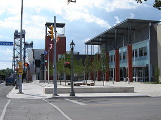
Welland is a city in the Regional Municipality of Niagara in Southern Ontario, Canada. As of 2021, it had a population of 55,750.

The Regional Municipality of Niagara, also colloquially known as the Niagara Region or Region of Niagara, is a regional municipality comprising twelve municipalities of Southern Ontario, Canada. The regional seat is in Thorold. It is the southern end of the Golden Horseshoe, the largest megalopolis in Canada.
King's Highway 58, commonly referred to as Highway 58, is a provincially maintained highway in the Canadian province of Ontario. The route is divided into two segments with a combined length of 15.5 km (9.6 mi). The southern segment travels from Niagara Regional Road 3, formerly Highway 3, in Port Colborne, to the Highway 58A junction in the southern end of Welland, a distance of 7.2 km (4.5 mi). The northern segment begins at Highway 20 near Allanburg and travels north and west to a large junction with Highway 406 at the St. Catharines – Thorold boundary, a distance of 8.3 km (5.2 mi). An 18.1 km (11.2 mi) gap separates the two segments within Welland and Pelham. The entire route is located within the Regional Municipality of Niagara.

King's Highway 3, commonly referred to as Highway 3, is a provincially maintained highway in the Canadian province of Ontario which travels parallel to the northern shoreline of Lake Erie. It has three segments, the first of which travels from the Ambassador Bridge in Windsor to Highway 77 in Leamington. The second portion begins at Talbotville Royal outside of St. Thomas at Highway 4, and travels to the western city limits of Port Colborne. The road is regionally maintained within Port Colborne as Niagara Regional Road 3, but regains its provincial designation at Highway 140. Its third and final terminus is at Edgewood Park, within the Fort Erie town limits. From there, the road continues as Niagara Regional Road 3 to the Peace Bridge, where drivers can cross to the United States. The total length of Highway 3 is 258.2 km (160.4 mi), consisting of 49.2 km (30.6 mi) from Windsor to Leamington, 187.9 km (116.8 mi) from Talbotville Royal to Port Colborne and 21.1 km (13.1 mi) from Port Colborne to Edgewood Park.
King's Highway 406, commonly referred to as Highway 406, is a 400-series highway in the Canadian province of Ontario. The primary north–south route through the central portion of the Niagara Peninsula, Highway 406 connects Welland, Thorold and downtown St. Catharines to the Queen Elizabeth Way (QEW).

The Mid-Peninsula Highway is a proposed freeway across the Niagara Peninsula in the Canadian province of Ontario. Although plans for a highway connecting Hamilton to Fort Erie south of the Niagara Escarpment have surfaced for decades, it was not until The Niagara Frontier International Gateway Study was published by the Ministry of Transportation of Ontario (MTO) in 1998 that serious examination and planning began. The study called for an alternative route to the QEW, which runs through tender fruitlands and is not capable of expansion beyond its current configuration. The land on which studies are being performed for this future freeway is referred to as the Mid-Peninsula Corridor or the Niagara–GTA Corrdior.
Cooks Mills is a small community in the easternmost part of the city of Welland in Ontario, Canada. It was established, and is still centred, on a Welland River tributary called Lyons Creek. It is almost entirely a bedroom community, as there are few employers located in the area.
King's Highway 140, commonly referred to as Highway 140, is a provincially maintained highway in the Canadian province of Ontario. The highway connects Port Colborne near Lake Erie with Highway 406 in Welland, via the Main Street Tunnel. It was constructed in the early 1970s as part of the Welland Bypass project of the Welland Canal, which resulted in the severance of several highways and rail lines. Opened to traffic in late 1972, several months following the tunnel, Highway 140 has remained unchanged since, despite growing calls to resign it as an extension of Highway 406.

The Main Street Tunnel, located in Welland, Ontario, Canada, is an underwater tunnel, carrying Niagara Road 27 and the unsigned designation of Highway 7146 under the Welland Canal. It is named as a part of East Main Street.

The Townline Tunnel is an underwater tunnel in Welland, Ontario, Canada carrying Highway 58A as well as the Canadian Pacific Railway under the Welland Canal.

The Welland By-pass, completed in 1973, was a massive construction project on the Welland Canal in Ontario, Canada.

The Welland Recreational Waterway is a water channel in the city of Welland, Ontario, Canada. It is an old alignment of the Welland Ship Canal that was abandoned after the construction of the Welland By-Pass in the 1970s. The Waterway is now managed by the Welland Recreational Canal Corporation to provide enjoyment for the city's residents. Most local residents refer to it as the old canal or simply the canal.
King's Highway 20, commonly referred to as Highway 20, is a provincially maintained highway in the Canadian province of Ontario. Presently, it is a short 1.9 km (1.2 mi) stub between Highway 58 and Niagara Regional Road 70 in the City of Thorold, but until 1997 it connected Hamilton to Niagara Falls, serving several towns atop the Niagara Escarpment en route.
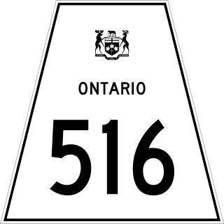
Secondary Highway 516, commonly referred to as Highway 516, is a provincially maintained secondary highway in the Canadian province of Ontario. The highway is 103.6-kilometre (64.4 mi) in length, connecting Highway 72 and Highway 642 near Sioux Lookout with Highway 599 north of Savant Lake.
The Niagara Parkway, formerly known as Niagara Boulevard and historically as the Niagara Road, is a scenic road in the province of Ontario that travels on the Canadian side of the Niagara River from the town of Fort Erie to Niagara-on-the-Lake. The portion north of Table Rock in the city of Niagara Falls is designated as an Ontario Scenic Highway. Niagara Boulevard originally referred only to the section from Fort Erie to Chippawa.
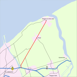
King's Highway 55, commonly referred to as Highway 55 and historically as the Niagara Stone Road and Black Swamp Road, was a provincially maintained highway in the Canadian province of Ontario, which connected the Queen Elizabeth Way (QEW) with Niagara-on-the-Lake, following Niagara Stone Road. The route divided a swath of wineries at the foot of the Niagara Escarpment, passing at an oblique angle to the concession road grid.
King's Highway 136, commonly referred to as Highway 136, was a provincially maintained highway in the Canadian province of Ontario that connected former Highway 24 near Caledon with Highway 9 in Orangeville. The majority of the route was located in the Regional Municipality of Peel; however, the section in Orangeville was in Dufferin County. The route of Highway 136 was originally part of Highway 24; it was created in 1962 when Highway 24 was rerouted along Highway 51. The highway remained unchanged until 1997, when it was transferred to the Regional Municipality of Peel and the Town of Orangeville.
King's Highway 42, commonly referred to as Highway 42, was a provincially maintained highway in the Canadian province of Ontario. The 52.8-kilometre (32.8 mi)-long route connected Highway 29 at Forthton with the town of Westport, intersecting Highway 15 en route. Highway 42 was assumed in 1935, and aside from paving the partially gravelled road, generally remained unchanged throughout its existence. In 1997, it was decommissioned and transferred to the United Counties of Leeds and Grenville, subsequently being redesignated as Leeds and Grenville County Road 42.
King's Highway 45, commonly referred to as Highway 45, was a provincially maintained highway in the Canadian province of Ontario. The 54.1-kilometre-long (33.6 mi) route connected Highway 2 in downtown Cobourg with Highway 7 in Norwood. In addition to the towns at either end, it bisected the communities of Baltimore, Fenella, Alderville, Roseneath and Hastings.


