King's Highway 4, also known as Highway 4, is a provincially maintained highway in the Canadian province of Ontario. Originally much longer than its present 100.8 km (62.6 mi) length, more than half of Highway 4 was transferred to the responsibility of local governments in 1998. It travels between Highway 3 in Talbotville Royal, north-west of St. Thomas, and Highway 8 in Clinton, passing through the city of London inbetween.
Highbury Avenue is an arterial road and municipal expressway located in the Canadian province of Ontario. In addition to serving as a primary north–south thoroughfare in eastern London – through which part of it is a limited-access freeway – the road also provides access to Highway 401 and continues south to St. Thomas. The southern terminus of Highbury Avenue is an intersection with South Edgeware Road, just north of Highway 3 and the eastern end of the St. Thomas Expressway. From there, it travels 45.6 kilometres (28.3 mi) north to Highway 7, east of Elginfield. Outside of London and St. Thomas, the road also passes through the communities of Ballymote and Bryanston. It is designated as Elgin County Road 30 within Central Elgin, and as Middlesex County Road 23 within Middlesex Centre, the two rural municipalities through which the route passes.
King's Highway 31, commonly referred to as Highway 31 and historically known as the Metcalfe Road, was a provincially maintained highway in the Canadian province of Ontario. The 76.93-kilometre (47.80 mi) route connected Highway 2 in Morrisburg with the Chaudière Bridge at the Ontario–Quebec boundary in downtown Ottawa.
King's Highway 24, commonly referred to as Highway 24, is a highway in the Canadian province of Ontario that currently begins at Highway 3 in Simcoe, and ends at the southern city limits of Cambridge. The south–north route travels through Brantford, as well as the community of Scotland. Outside of those communities, Highway 24 travels through a predominantly agricultural area.
King's Highway 37, commonly referred to as Highway 37, is a provincially maintained highway in the Canadian province of Ontario. It begins at Highway 401 in Belleville and travels 44.2 km (27.5 mi) north to Highway 7 in Actinolite. The route once continued south through Belleville to Highway 62, but was truncated in 1998. Prior to the re-routing, Highway 37 was 47.2 km (29.3 mi) long.
King's Highway 40, commonly referred to as Highway 40, is a provincially maintained highway in the southwestern portion of the Canadian province of Ontario. The 91.4-kilometre (56.8 mi) route links Chatham and Sarnia via Wallaceburg, following close to the St. Clair River. The southern terminus is at Highway 401 south of Chatham, while the northern terminus is at Highway 402 in Sarnia. The portion of Highway 40 between Highway 401 and north of Wallaceburg is within the municipality of Chatham-Kent, while the portion north of there is within Lambton County.
King's Highway 98, commonly referred to as Highway 98, was a provincially maintained highway in the Canadian province of Ontario, designated as part of the provincial highway system between 1939 and 1971. The route travelled through the northern part of Essex County and through south-central Chatham-Kent, extending 96.3 kilometres (59.8 mi) from Windsor to Blenheim. Since 1998, it has been known as Essex County Road 46 between Windsor and Tilbury, and Chatham-Kent Road 8 between Tilbury and Blenheim.
King's Highway 15, commonly referred to as Highway 15, is a provincially maintained highway in the Canadian province of Ontario. It travels north from an interchange with Highway 401 in Kingston to Highway 7 in Carleton Place, a distance of 114.7 kilometres (71.3 mi). In addition to Kingston and Carleton Place, the highway provides access to the Eastern Ontario communities of Joyceville, Seeley's Bay, Morton, Elgin, Crosby, Portland, Lombardy and Franktown. Prior to 1998, Highway 15 continued north from Carleton Place, passed Almonte and through Pakenham, to Highway 17 in Arnprior.
King's Highway 19, commonly referred to as Highway 19, is a provincially maintained highway in the Canadian province of Ontario, connecting Highway 3 in Tillsonburg with Highway 401 southeast of Ingersoll. The highway began as the Plank and Gravel Road, a toll road formed by the Ingersoll and Port Burwell Road Company. It was first assigned in 1930. Several extensions in the early 1930s took the route north to Highway 86 at Tralee. However, a significant amount of Highway 19 was decommissioned and turned over to local and county governments in 1997 and 1998.
King's Highway 49, commonly referred to as Highway 49, is a provincially maintained highway in the Canadian province of Ontario. The 5.8-kilometre (3.6 mi) highway travels across the Quinte Skyway and through the Tyendinaga Mohawk Territory south of Marysville.
King's Highway 135, commonly referred to as Highway 135, was a provincially maintained highway in the Canadian province of Ontario on the southern edge of London, following Exeter Road, which it is better known as. The road's main purpose was to link Highway 401 in London with Highway 2 in Lambeth, at a time when the London-area section of Highway 401 was only completed to the interchange with Highway 4.
King's Highway 38, commonly referred to as Highway 38, was a provincially maintained highway in the Canadian province of Ontario. The 66.9-kilometre (41.6 mi) road connected Highway 2 and Highway 401 in Kingston with Highway 7 west of Perth. It was designated in 1934 and remained relatively unchanged throughout its existence, aside from some minor diversions and a rerouting through Kingston as a result of the construction of Highway 401 in the mid-1950s. At the beginning of 1998, the entire highway was transferred to the municipalities of Frontenac County through which it travelled: Kingston, South Frontenac and Central Frontenac. Today the former highway is named Road 38 and Gardiners Road, but is still referred to as Highway 38 by locals.
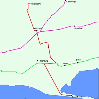
King's Highway 59, commonly referred to as Highway 59, was a provincially maintained highway in the Canadian province of Ontario. It connected Long Point Provincial Park in Norfolk County to the town of Shakespeare in Perth County, passing through the city of Woodstock in Oxford County en route. Several smaller towns also lined the highway, notably Courtland, Delhi, Norwich and Tavistock. Highway 59 featured junctions with Highway 3, Highway 2, Norfolk County Highway 24 and the concurrent routes of Highway 7 and Highway 8. Highway 59 also had an interchange with Highway 401.
King's Highway 73, commonly referred to as Highway 73, was a provincially maintained highway in the Canadian province of Ontario. The route began in Port Bruce and progressed north through Aylmer, encountering Highway 401 immediately before terminating east of Dorchester. The route was established in mid-1937, remaining unchanged for nearly six decades before being transferred to Elgin County and Middlesex County in 1997 and 1998. Today the route is known as Elgin County Road 73 and Middlesex County Road 73.
King's Highway 80, commonly referred to as Highway 80, was a provincially maintained highway in the Canadian province of Ontario. It travelled in an east–west direction south of Sarnia from Courtright to Strathburn. Beginning at the St. Clair Parkway near the shores of the St. Clair River, the route travelled 69.6 kilometres (43.2 mi), intersecting Highway 40, Highway 21 and Highway 79 before ending at Highway 2. In addition to the towns at either terminus, Highway 80 serviced the communities of Brigden, Glencoe and Alvinston. The entire route was and remains two lanes wide.
King's Highway 81, also known as Highway 81, was a provincially maintained highway in the Canadian province of Ontario. The winding north–south route connected Highway 2 in Delaware with Highway 21 in Grand Bend, passing through Mount Brydges, Strathroy and Parkhill en route. Highway 81 was first designated in 1936 and extended in 1937, and retained generally the same route throughout its existence until it was transferred to the responsibility of Middlesex County and Huron County in 1997 and 1998. Today the entire route is known as Middlesex County Road 81 and Huron County Road 81.
King's Highway 22, commonly referred to as Highway 22, was a provincially maintained highway in the Canadian province of Ontario, located between Sarnia and London. Since 1998, the majority of the former route has been known as Middlesex County Road 22 and Lambton County Road 22. It began at Highway 7 and Highway 79 north of Watford and proceeded 46.0 kilometres (28.6 mi) east to Highway 4 in the north end of London. Between those two points, it passed through the small communities of Wisbeach, Dejong, Adelaide, Wrightmans Corners, Hickory Corner, Poplar Hill, Lobo, and Melrose. The highway was located within Lambton County, Middlesex County, and the city of London, and it followed the historic Egremont Road
King's Highway 29, commonly referred to as Highway 29, was a provincially maintained highway in the Canadian province of Ontario. The 52.29-kilometre (32.49 mi) route connected Highway 2 in downtown Brockville with Highway 15 south of Smiths Falls. Between those larger settlements, it provided access to the communities of Forthton, Addison, Frankville, Toledo and Newbliss.
King's Highway 45, commonly referred to as Highway 45, was a provincially maintained highway in the Canadian province of Ontario. The 54.1-kilometre-long (33.6 mi) route connected Highway 2 in downtown Cobourg with Highway 7 in Norwood. In addition to the towns at either end, it bisected the communities of Baltimore, Fenella, Alderville, Roseneath and Hastings.
King's Highway 74, commonly referred to as Highway 74, was a provincially maintained highway in the Canadian province of Ontario that travelled north from Highway 3 at New Sarum to Middlesex County Road 29 on the outskirts of London. The 22.4-kilometre-long (13.9 mi) was assumed by the province in September 1937. Aside from paving and the construction of an interchange with Highway 401, it remained generally unchanged for the next six decades until it was decommissioned in 1997 and transferred to Elgin County and Middlesex County. The road has since been redesignated as Elgin County Road 74 and Middlsex County Road 74.


