King's Highway 17, more commonly known as Highway 17, is a provincially maintained highway and the primary route of the Trans-Canada Highway through the Canadian province of Ontario. It begins at the Manitoba boundary, 50 km (31 mi) west of Kenora, and the main section ends where Highway 417 begins just west of Arnprior. A small disconnected signed section of the highway still remains within the Ottawa Region between County Road 29 and Grants Side Road. This makes it Ontario's longest highway.
King's Highway 417, commonly referred to as Highway 417 and as the Queensway through Ottawa, is a 400-series highway in the Canadian province of Ontario. It connects Ottawa with Montreal via A-40, and is the backbone of the highway system in the National Capital Region. Within Ottawa, it forms part of the Queensway west from Highway 7 to Ottawa Road 174. Highway 417 extends from the Quebec border, near Hawkesbury, to Arnprior, where it continues westward as Highway 17. Aside from the urban section through Ottawa, Highway 417 passes through farmland that dominates much of the fertile Ottawa Valley.
King's Highway 60, commonly referred to as Highway 60, is a provincially maintained highway in the Canadian province of Ontario. The 255.8-kilometre (158.9 mi) highway serves as the primary corridor through Algonquin Provincial Park, where it is dedicated as the Frank McDougall Parkway. East of Algonquin Park, the route serves east–west traffic in the highlands of central Ontario. It begins at Highway 11 in Huntsville and ends at Highway 17 near Renfrew.
King's Highway 69, commonly referred to as Highway 69, is a provincially maintained north–south highway in the central portion of the Canadian province of Ontario. In conjunction with Highway 400, it links Toronto with the city of Greater Sudbury at Highway 17, via Parry Sound. It is part of the Trans-Canada Highway and the National Highway System. From its southern terminus of Highway 559 at Carling, Highway 69 begins as Highway 400 narrows from a four-laned freeway to a two lane highway. It travels northerly for approximately 68 kilometres (42 mi) to south of the French River before widening back to a divided four lane freeway for approximately 64 kilometres (40 mi) into Sudbury. The final 6 kilometres (3.7 mi) of the route, connecting to Highway 17, is a five lane arterial road that will be converted to freeway as the final phase of the four-laning.
King's Highway 16, commonly referred to as Highway 16 and historically as the Prescott Highway, is a provincially maintained highway in the Canadian province of Ontario. The highway once travelled from near Prescott to Ottawa, traversing the distance between the St. Lawrence River and the Ottawa River. However, its length was truncated significantly when most of the route was twinned with a second roadway, and renumbered as Highway 416. A short stub remains through Johnstown, providing access to the Ogdensburg–Prescott International Bridge across the St. Lawrence River to Ogdensburg, New York, where New York State Route 812 continues south.
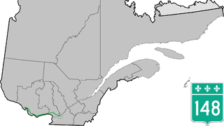
Route 148 is an east-west highway in Quebec, Canada. It runs from junction of Autoroute 13 and Autoroute 440 in Laval in the Montreal region to the Ontario-Quebec border in L'Isle-aux-Allumettes in western Quebec. For most of its length, Route 148 follows the north shore of the Ottawa River where it acted as the principal route between communities in the Outaouais region until the completion of Autoroute 50 in 2012. At the Ontario-Quebec border in L'Isle-aux-Allumettes Route 148 continues into Ontario as Highway 148.
King's Highway 31, commonly referred to as Highway 31 and historically known as the Metcalfe Road, was a provincially maintained highway in the Canadian province of Ontario. The 76.93-kilometre (47.80 mi) route connected Highway 2 in Morrisburg with the Chaudière Bridge at the Ontario–Quebec boundary in downtown Ottawa.
King's Highway 37, commonly referred to as Highway 37, is a provincially maintained highway in the Canadian province of Ontario. It begins at Highway 401 in Belleville and travels 44.2 km (27.5 mi) north to Highway 7 in Actinolite. The route once continued south through Belleville to Highway 62, but was truncated in 1998. Prior to the re-routing, Highway 37 was 47.2 km (29.3 mi) long.
King's Highway 28, commonly referred to as Highway 28, is a provincially maintained highway in the Canadian province of Ontario. The southwest–northeast route extends from Highway 7 east of Peterborough, to Highway 41 in Denbigh. The route passes over undulating hills before entering the Canadian Shield near Burleigh Falls, and gradually turns eastward.
King's Highway 62, commonly referred to as Highway 62, is a provincially maintained highway in the Canadian province of Ontario. The highway travels south–north from Highway 33 at Bloomfield in Prince Edward County, through Belleville, Madoc and Bancroft, to Maynooth, where it ends at a junction with Highway 127. Prior to 1997, the route continued north and east of Maynooth through Cobermere, Barry's Bay, Killaloe, Round Lake and Bonnechere to Highway 17 in Pembroke. This section of highway was redesignated Hastings Highlands Municipal Road 62, Renfrew County Road 62, and Renfrew County Road 58.
King's Highway 127, commonly referred to as Highway 127, is a provincially maintained highway in the Canadian province of Ontario. The route begins in Maynooth, connecting Highway 62 north of Bancroft with Highway 60 in the township of South Algonquin, east of Whitney and Algonquin Provincial Park. The entire route is patrolled by the Ontario Provincial Police (OPP).
King's Highway 15, commonly referred to as Highway 15, is a provincially maintained highway in the Canadian province of Ontario. It travels north from an interchange with Highway 401 in Kingston to Highway 7 in Carleton Place, a distance of 114.7 kilometres (71.3 mi). In addition to Kingston and Carleton Place, the highway provides access to the Eastern Ontario communities of Joyceville, Seeley's Bay, Morton, Elgin, Crosby, Portland, Lombardy and Franktown. Prior to 1998, Highway 15 continued north from Carleton Place, passed Almonte and through Pakenham, to Highway 17 in Arnprior.
King's Highway 41, commonly referred to as Highway 41, is a provincially maintained highway in the Canadian province of Ontario. The 159.6-kilometre (99.2 mi) highway travels in a predominantly north–south direction across eastern Ontario, from Highway 7 in Kaladar to Highway 148 in Pembroke. The majority of this distance crosses through a rugged forested region known as Mazinaw Country. However, the route enters the agricultural Ottawa Valley near Dacre. A significant portion of Highway 41 follows the historic Addington Colonization Road, built in 1854.
King's Highway 49, commonly referred to as Highway 49, is a provincially maintained highway in the Canadian province of Ontario. The 5.8-kilometre (3.6 mi) highway travels across the Quinte Skyway and through the Tyendinaga Mohawk Territory south of Marysville.
King's Highway 130, commonly known as Highway 130, is a provincially maintained highway in the Canadian province of Ontario. It begins at a junction with Highway 61 and travels 15.4 km (9.6 mi) north-west to the Trans-Canada Highway, Highway 11 and Highway 17, west of Thunder Bay. Highway 130 is a short connecting highway, and passes entirely through the outskirts of Thunder Bay, connecting several minor communities and providing a shortcut for traffic travelling from the south to the west or vice versa. The speed limit along the highway is 80 km/h (50 mph); it is patrolled by the Ontario Provincial Police.
King's Highway 132, commonly referred to as Highway 132, is a provincially maintained highway the Canadian province of Ontario. Its western terminus is at Highway 41 near Dacre while its eastern terminus is at Highway 60 in Renfrew. The length of Highway 132 is 30.3 km (18.8 mi), situated entirely in Renfrew County. It travels through the communities of Shamrock, Dacre and Renfrew.
King's Highway 85, commonly referred to as Highway 85, is a provincially maintained highway in the Canadian province of Ontario, connecting Highway 7 to immediately north of the Waterloo city limits. The 10-kilometre (6.2 mi) highway, which is mostly controlled-access, travels through the Regional Municipality of Waterloo along the Conestoga Parkway from its interchange with Highway 7, which continues south along the parkway, to an interchange with Regional Road 15, where it continues as Regional Road 85 to St. Jacobs.
Highway 17B was formerly the designation for six business routes of Highway 17, the main route of the Trans-Canada Highway through the Canadian province of Ontario. Each generally followed the original route of Highway 17 through the town or city that it served, and was subsequently given the Highway 17B designation when a newer bypass route was constructed to either reduce traffic pressure on the local street network, or provide a better thoroughfare that avoided urban areas altogether.
King's Highway 44, commonly referred to as Highway 44, was a provincially maintained highway in the Canadian province of Ontario. The 15.9-kilometre (9.9 mi)-long route began at Highway 15 in the town of Almonte and travelled eastward through Lanark County towards Ottawa, ending at Highway 17. Highway 44 was assumed by the province in 1938 along existing unimproved roadway. A significant portion of the highway was incorporated into a new routing of Highway 17 in 1966. The highway alignment remained generally unchanged for the next three decades until it was decommissioned in 1997 and transferred to Lanark County and what is now the City of Ottawa. The road has since been redesignated as Lanark County Road 49 and Ottawa Road 49.
King's Highway 29, commonly referred to as Highway 29, was a provincially maintained highway in the Canadian province of Ontario. The 52.29-kilometre (32.49 mi) route connected Highway 2 in downtown Brockville with Highway 15 south of Smiths Falls. Between those larger settlements, it provided access to the communities of Forthton, Addison, Frankville, Toledo and Newbliss.