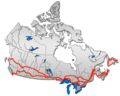
Timiskaming is a district and census division in Northeastern Ontario in the Canadian province of Ontario. The district was created in 1912 from parts of Algoma, Nipissing, and Sudbury districts. In 1921, Cochrane District was created from parts of this district and parts of Thunder Bay District.
King's Highway 101, commonly referred to as Highway 101, is a provincially maintained highway in the Canadian province of Ontario. The 473.3-kilometre (294.1 mi) highway connects Highway 17 west of Wawa with Highway 11 in Matheson before continuing east to the Ontario–Quebec border where it becomes Route 388. The highway forms one of the only connections between the two routes of the Trans-Canada Highway between Nipigon and Temagami, and crosses some of the most remote regions of Northern Ontario. Major junctions are located with Highway 129 near Chapleau and Highway 144 southwest of Timmins, though the distance between these junctions is significant.
King's Highway 17, more commonly known as Highway 17, is a provincially maintained highway and the primary route of the Trans-Canada Highway through the Canadian province of Ontario. It begins at the Manitoba boundary, 50 km (31 mi) west of Kenora, and the main section ends where Highway 417 begins just west of Arnprior. A small disconnected signed section of the highway still remains within the Ottawa Region between County Road 29 and Grants Side Road. This makes it Ontario's longest highway.

Secondary Highway 519, commonly referred to as Highway 519, is a provincially maintained highway in the Canadian province of Ontario. The highway is 30.5 km (19.0 mi) in length, connecting Highway 17 near Obatanga Provincial Park with Dubreuilville station. A private logging road continues east from that point.
King's Highway 64, commonly referred to as Highway 64, is a provincially maintained highway in the Canadian province of Ontario, connecting Highway 69 north of the French River with Highway 11 at Marten River, via Highway 17 west of Sturgeon Falls. The route serves several communities along the north shore of the French River and west shore of Lake Nipissing as it travels from Highway 69 to Highway 17. North of Sturgeon Falls, the highway provides a shortcut between Highway 17 and Highway 11 northwest of North Bay.

Gauthier is a township municipality in Timiskaming District the Northeastern Ontario, Canada. The township had a population of 138 in the Canada 2016 Census. Its main population centre is Dobie, located just north of Ontario Highway 66, 18.5 kilometres (11.5 mi) east of Kirkland Lake.
King's Highway 23, commonly referred to as Highway 23, is a provincially maintained highway in the Canadian province of Ontario. The route travels from Highway 7 east of Elginfield north to Highway 9 and Highway 89 in Harriston. The total length of Highway 23 is 97.7 kilometres. The highway was first established in 1927 between Highway 8 in Mitchell and Highway 9 in Teviotdale, via Monkton, Listowel and Palmerston. As part of a depression relief program, it was extended south to Highway 7 in 1934. It remained relatively unchanged until 2003, when it was rerouted northward from Palmerston to Harriston.
King's Highway 63, commonly referred to as Highway 63, is a provincially maintained highway in the Canadian province of Ontario. The 63.5-kilometre (39.5 mi) route travels from Highway 11 and Highway 17 in North Bay northeast to the Ontario-Quebec provincial boundary, where it continues as Route 101 into Témiscaming.
King's Highway 65, commonly referred to as Highway 65, is a provincially maintained highway in the Canadian province of Ontario. The route begins at Highway 66 and travels 123.3 kilometres (76.6 mi) southeast to the Quebec border. At its midpoint, the route is concurrent with Highway 11.
King's Highway 102, commonly referred to as Highway 102, formerly as Highway 11A and Highway 17A and historically as the Dawson Road, is a provincially maintained highway in the Canadian province of Ontario, serving as a northern bypass to the city of Thunder Bay for all vehicle traffic. Both the western and eastern termini of Highway 102 are with the concurrency of Highway 11 and Highway 17; in the rural community of Sistonens Corners to the west and in Thunder Bay to the east. The majority of Highway 102 is surrounded by thick forests and swamps. However, owing to its historic nature, it is lined with residences outside of urban Thunder Bay.
King's Highway 112, commonly referred to as Highway 112, is a provincially maintained highway in the northern portion of the Canadian province of Ontario. Formerly part of the Ferguson Highway, the route was designated with its own number in 1953, prior to which it formed a part of Highway 11. It travels east of the current Highway 11, around Round Lake and through Dane before ending at Highway 66 southwest of Kirkland Lake.
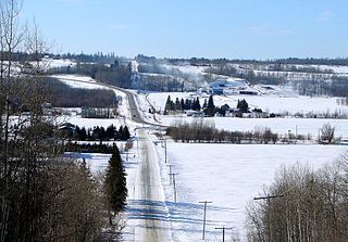
Kenogami Lake is an unincorporated place and community in the Unorganized West Part of Timiskaming District in northeastern Ontario, Canada. It is located on Kenogami Lake on the Blanche River in the Saint Lawrence River drainage basin.

Larder Lake is a freshwater lake in Timiskaming District in Northeastern Ontario, Canada. The lake straddles the incorporated (municipal) townships of Larder Lake and McGarry and geographic McFadden Township. It is part of the Saint Lawrence River drainage basin and is the source of the Larder River.
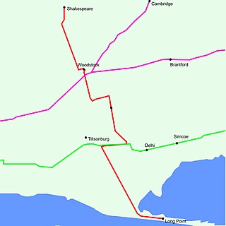
King's Highway 59, commonly referred to as Highway 59, was a provincially maintained highway in the Canadian province of Ontario. It connected Long Point Provincial Park in Norfolk County to the town of Shakespeare in Perth County, passing through the city of Woodstock in Oxford County en route. Several smaller towns also lined the highway, notably Courtland, Delhi, Norwich and Tavistock. Highway 59 featured junctions with Highway 3, Highway 2, Norfolk County Highway 24 and the concurrent routes of Highway 7 and Highway 8. Highway 59 also had an interchange with Highway 401.
King's Highway 121, commonly referred to as Highway 121, was a provincially maintained highway in the Canadian province of Ontario that connected several communities in the cottage country region of Central Ontario on the southern edge of the Canadian Shield. Between Fenelon Falls and Minden, Highway 121 served as an alternative route to Highway 35, which was severely congested during summer weekends. From Minden, the highway branched east to Haliburton Village and thereafter followed the present route of Highway 118 to Highway 28 in Paudash.

Secondary Highway 672, commonly referred to as Highway 672, is a provincially maintained secondary highway in the Canadian province of Ontario. The 47.6-kilometre (29.6 mi) route lies within Timiskaming and Cochrane district, connecting Highway 66 — part of the Trans-Canada Highway — in the south with Highway 101 in the north. It is the only highway to provide access to Esker Lakes Provincial Park. Though the highway was first assumed by the province in 1990, the existing road had been built north from Highway 66 to the provincial park in 1977 and extended to Highway 101 in the late 1980s.
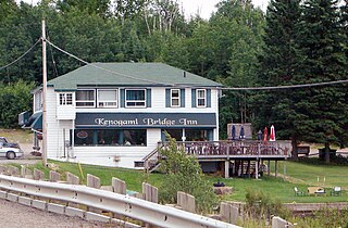
Kenogami Lake Station is an unincorporated place and railway point in the Unorganized West Part of Timiskaming District in northwestern Ontario, Canada. It is located on the Blanche River in the Saint Lawrence River drainage basin.

The Blanche River is a river in the Saint Lawrence River drainage basin in Timiskaming District in northeastern Ontario, Canada. The river is a tributary of Lake Timiskaming and its name is from the French for the colour "white".